WILDFIRE MANAGEMENT
Technologies for Forecasting, Detection, Mitigation, and Response
Statement of Karen L.
Howard, Ph.D, Director,
Science, Technology Assessment, and Analytics
Before the Subcommittee on Federal Lands, Committee on Natural Resources, House of Representatives
For Release on Delivery Expected at 10:00 a.m. ET
United States Government Accountability Office
A testimony before the Subcommittee on Federal Lands, Committee on Natural Resources, House of Representatives
For more information, contact: Karen L. Howard, PhD, at HowardK@gao.gov
What GAO Found
Some key technologies currently used in wildfire management include:
· Satellites, which provide data that are integrated into models for wildfire forecasting, including data on terrain, vegetation, and weather. They are also used for detection and monitoring, although some satellites face resolution issues, data lags, and other limitations.
· Aircraft and drones, which can deploy to the scene to collect information on a fire’s location and its potential to spread. Aircraft and drones with thermal cameras can see through smoke and dense trees, helping to locate fires and determine their intensity. Challenges include safety issues for aircraft pilots and limited drone lifespan (3 to 5 years, or less in harsh conditions).
· Cameras and air sensors, which are used in several states for wildfire detection, sometimes in extensive networked systems. For example, in 2024, Hawaiian Electric stated that it began deploying high-resolution cameras with artificial intelligence (AI) for early fire detection. For both cameras and sensors, installation, data transmission, and fire verification may be challenging in remote areas. Sensors may require dense networks to operate accurately.
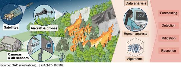
AI tools have the potential to improve modeling for wildfire forecasting and response. AI may help address key limitations of the traditional mathematical models used for wildfire. For example, AI can:
· Allow models to use more data by speeding up data assimilation, the process of updating forecasts with the most current observations.
· Rapidly flag potential inaccuracies for human review.
· Potentially reduce uncertainty in some situations when data do not exist or are insufficient, by using prior information to create plausible synthetic data.
However, use of AI in this field faces challenges. For example, AI requires extensive up-front work to ensure the data are readily usable by AI tools, which can be costly. AI also presents a risk of conveying inaccurate information, which can put lives and property at risk. In addition, historical data are limited for rare events, which may limit the utility of AI for forecasting extreme wildfires.
Why GAO Did This Study
Annually, wildfires in the U.S. cause an average of 12 deaths and cost at least $3.2 billion. Wildfire severity has increased across much of the country, a trend that is expected to continue. Current and emerging technologies have the potential to save lives and property by improving forecasting, detection, mitigation, and response.
This testimony provides information on selected technologies and on the benefits and limitations of AI tools to enhance use of these technologies. This statement is based on prior GAO work, including a 2023 report on the use of AI to model wildfires and other natural hazards; a 2025 report on wildfire detection technologies such as satellites, aircraft, drones, cameras, and sensors; and prior GAO reports on forest management, wildfire staffing, and interagency coordination on wildfire response.
What GAO Recommends
In prior work, GAO has provided policy questions and options, which policymakers could consider to improve adoption of wildfire technologies and the use of data. Policy options include: expanding the use of existing observational data and infrastructure to close data gaps, establishing guidelines for making data readily usable by AI, updating education requirements to include coursework related to machine learning (ML), considering what combination of detection technologies would be most cost-effective, and considering how the costs of technologies could be balanced with other fire management actions.
Chairman Tiffany, Ranking Member Neguse, and Members of the Subcommittee:
Thank you for the opportunity to discuss our work related to technologies that can be used for wildfire forecasting, detection, mitigation, and response, along with tools to potentially better incorporate data collected from these technologies.[1]
Introduction
Wildfires cause an average of 12 deaths each year and cost at least $3.2 billion annually in the U.S., according to the National Oceanic and Atmospheric Administration (NOAA).[2] The U.S. Geological Survey reports that wildfires burn about 7 million acres each year. Although fire plays an important ecological role, it can also destroy homes and infrastructure, disrupt power services, cause soil erosion or otherwise harm ecosystems, and produce smoke that can create unhealthy air quality.
In recent decades, wildfire severity has increased across much of the U.S., and the trend is expected to continue. Improved forecasting, detection, and response are essential to reducing wildfire damage. While many factors contribute to the nation’s readiness to forecast and respond to wildfires, current and emerging technologies have the potential to offer significant improvements.
My statement today discusses a selected suite of technologies at varying stages of development and use. These technologies provide key information for use in forecasting, detecting, and responding to wildfires. I will also discuss the opportunities and challenges associated with using artificial intelligence (AI) as a tool alongside these selected technologies.
Selected Wildfire Technologies Provide Essential Wildfire Data but Vary in Maturity and Use
Effective wildfire forecasting, detection, mitigation, and response require large amounts of data from many sources. These data cover factors such as topography, weather conditions, and the state of vegetation, such as trees and shrubs (known as fuels). Technologies such as satellites, aircraft, drones, cameras, and sensors are used to gather and analyze such information.[3]
Satellites
Satellites provide extensive data that are integrated into models for wildfire forecasting, including data on:
· Terrain: features such as slopes, water bodies, and roads.
· Fuels: characterization, locations, and moisture levels.
· Weather: anticipated wind speeds and storms that could cause lightning or rain.
|
Example of Satellite Use for Wildfires U.S. government satellites have been used to detect wildfires for decades. For example, in 2016 NOAA and NASA began launching the Geostationary Operational Environmental Satellites (GOES)-R Series, the nation’s most advanced fleet of geostationary weather satellites. They use both visible and infrared wavelengths to locate fires and measure their size, temperature, and radiative power. GOES-R Series satellites have detected fires before they were spotted on the ground. Source: NASA and NOAA. | GAO‑25‑108589 |
Satellites are also important for detecting and monitoring active wildfires. Satellites can capture images indicating fire over large areas. They are especially helpful in remote locations that may be difficult to monitor with other technologies. Detecting wildfires from space often relies on thermal-infrared imagery to detect heat signatures of active fires or smoldering areas. This imagery can be combined or overlaid with other data to help predict the fire’s behavior and develop response strategies. Once detected, satellites are also used to track speed, direction, and size of the fire.
However, detecting or tracking fires from space has limitations. Geostationary satellites are high above the Earth, limiting their resolution. Lower-orbiting satellites are not geostationary so are only over a fire for a short time, then take more than an hour to return. Other disadvantages can include cloud interference and data lags.
Aircraft and Drones
Aircraft and drones can be used for multiple purposes:
· Some utility companies use drones to mitigate fire risk by inspecting downed power lines and tree branches touching wires, and to prioritize where to focus maintenance.
· The Forest Service, Department of the Interior (Interior), and other firefighting agencies can deploy aircraft and drones to the scene quickly to collect information on a fire’s location and its potential to spread. Aircraft and drones with thermal cameras can see through smoke and dense trees, helping to locate fires and determine their intensity.
The U.S. has used aircraft for wildfire detection since the 1920s. Today, aircraft are used on an ad hoc basis when weather or seasonal conditions warrant the cost to fly patrols. However, smoke and fire pose risks to pilots, making uncrewed systems appealing. Interior officials stated that drones offer safety, cost, and data collection advantages over ground-based or crewed aircraft methods.
|
Example Limitation of Drone Availability From January 2020 through October 2022, Interior prohibited the procurement and nonemergency use of drones manufactured by companies in countries designated as adversary nations. In response to this policy, the selected bureaus halted all nonemergency drone flights during this time frame, according to officials. As of June 2024, use of otherwise prohibited drones was exempted for wildfire management purposes. Interior has faced challenges with resuming nonemergency drone flights because of an insufficient number of drones, according to officials. This has affected Interior operations in various ways, such as lost opportunities to collect data. Source: GAO. | GAO‑25‑108589 |
However, there are some disadvantages to the use of aircraft and drones, and agencies have experienced some challenges with adoption.
· Interior’s drones have a typical lifespan of about 3 to 5 years, officials said, but this can be shortened by factors including operating in harsh environments.
· Fire response agencies’ ability to use aircraft or drones can be inhibited if unauthorized drones from civilians are flying near the wildfires. First responders often ground their aircraft or drones to avoid the potential for a midair collision, which can delay response and allow wildfires to grow larger.[4]
· Staffing issues may arise, since drone and aircraft pilots need specific training and certification.
Ground-based Cameras and Sensors
Cameras can monitor for smoke or fire in real time. Sensors on or near trees can look for changes in heat, humidity, particulates, or certain gases that may indicate a fire. Although cameras and sensors are not new, a more recent development is to arrange them in networks within areas of high fire risk and incorporate use of AI. These networks may enable faster detection and response in such areas.
Several states report using ground-based cameras, with recent installations of extensive networked systems. For example, last year, Hawaiian Electric stated that it began deploying high-resolution video cameras with AI for early detection of wildfires. These cameras use human verification to reduce false alerts, among other things. In 2023, California began using an AI system to detect wildfires using images from over 1,100 cameras statewide, including 24-hour monitoring with night vision capabilities. According to ALERTCalifornia, this system detected over 1,200 confirmed fires in 2023, sometimes before firefighters received 911 calls.[5] The system has also detected fires in remote locations and at night, when human spotters are more likely to miss them.
There have also been several recent deployments of sensors designed to detect increasing amounts of chemical compounds that may indicate smoke and fire, including carbon dioxide, nitrous oxide, and sulfur dioxide. Because smoke sensors do not rely on visual surveillance, they can operate when visibility is poor.
However, cameras and sensors have some disadvantages and challenges. For example:
|
Examples of Sensor Deployment The Air Force reported that, in October 2024, it deployed 14 sensors to cover over 1,000 acres at the Kirtland Airforce Base in New Mexico. It reported that it was the first system of its kind in the Department of Defense and in New Mexico. From 2023 to 2024, the Department of Homeland Security and the University of Oregon deployed 30 sensors across Western Oregon for field testing. Source: Air Force and DHS. | GAO‑25‑108589 |
· For both cameras and sensors, verification and data transmission may be challenging in remote areas. Installing cameras and sensors in remote locations may also require additional labor. In addition, they must be durable in different weather conditions and have a good power source. When a wildfire occurs, they may be burned and need to be replaced.
· Cameras can miss fires hidden behind natural barriers or may see only part of a wildfire.
· Some sensors require calibration to achieve high accuracy, which might not be possible if users need to deploy sensors quickly during an emergency. For wildfire detection, they may also require dense networks to operate accurately and to reduce false alarms.
Artificial Intelligence Tools Have the Potential to Improve Data Use, but Limitations Apply
Computer modeling is a critical tool for natural disaster forecasting—and traditional, physics-based models have been used for wildfires for more than 50 years. AI introduces the opportunity to enhance the speed, accuracy, and effectiveness of traditional models.
In the simplest of terms, models are built by identifying patterns in historical data and applying those patterns to new data to generate useful predictions. Forecasting is a multi-step process that includes modeling (see fig. 1).
Figure 1: Basic Steps of Forecasting a Natural Hazard Event
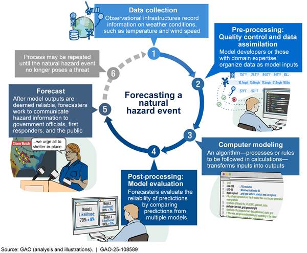
Note: Observations from step 2 to step 5 can be used directly to improve the interpretation of the forecast.
Wildfire forecasts rely on data about current conditions from a variety of sources—including data collected by satellites, drones, sensors, and other selected wildfire technologies discussed in this testimony.
|
Example Traditional Wildfire Model An example of a commonly used traditional wildfire model in the U.S. is the Rothermel surface fire spread model. It uses a variety of data, including data on wind, slope, the amount of dead and living vegetation (known as fuel), and the moisture content of the fuel. These and other variables are put into a mathematical model that uses the laws of physics to estimate how fast a wildfire will spread based on the relationship between fuel and the amount of heat required to ignite that fuel type. The model uses these variables to predict fire spread based on when the estimated heat generated exceeds the heat needed to ignite adjacent unburned fuel. Source: GAO. | GAO‑25‑108589 |
Traditional, physics-based models of wildfire demand detailed datasets on such factors as the location and dimensions of trees and other fuel. These data are difficult to obtain for large areas, and the resulting models often require too much computing power to run in real time. Some other traditional models are faster and can be adequate for large areas, but they are often less accurate because they leave out some of the complexity of wildfire spread.
AI is a powerful tool that can automate processes, rapidly analyze massive datasets, enable modelers to gain new insights, and boost efficiency. Machine learning (ML), a type of AI, uses algorithms to identify and learn from patterns in information. In natural disaster forecasting, modelers are beginning to use AI—including ML—to efficiently harness more of the information that is available about the environment, thereby significantly improving the timeliness, accuracy, and precision of natural disaster forecasting. They are doing this in a range of ways, from running AI models alongside traditional models, to incorporating AI into traditional models, to fully replacing traditional models with AI models.
According to wildfire researchers we interviewed as a part of our 2023 report, the majority of ML applications to wildfire modeling have been for improving model inputs—such as vegetation type, vegetation coverage, and weather conditions.[6] Applying ML to wildfire spread models is a promising research area still in the early stages of development. ML techniques may help address some of the key limitations of traditional modeling. For example, ML:
· Can speed up data assimilation—the process of updating forecast models by repeatedly integrating the most current environmental observations to best represent the initial conditions for a prediction. Faster data assimilation could allow models to use more data.
· Could improve the use of data by speeding up the quality assurance and quality control processes used for natural hazard models by flagging potential inaccuracies for human review.
· Could expand the use of satellite imagery.
· Has the potential to reduce uncertainty in some situations where data do not exist or are insufficient, by using prior information to create plausible synthetic data.
· Has the potential to improve ensemble modeling. Ensemble modeling can reduce the uncertainty in model predictions by using multiple models (rather than one) and combining their predictions.
In addition to improving wildfire modeling, ML is increasingly used in the U.S. to enhance various wildfire management and mitigation efforts. Specifically, ML is starting to be used to: (1) forecast potential wildfire occurrence and risk, (2) improve wildfire response, and (3) mitigate wildfire risk. For forecasting wildfire occurrence and risk, researchers have used ML to combine satellite imagery with existing ground surveys to estimate the amount of vegetation and other fuel in areas where data were sparse or outdated. In one study, ML improved the accuracy of wildfire model estimates by 38 percent.[7]
In 2023, Forest Service officials told us three of their six models used ML. One of them, Potential Control Locations, was used in a 2022 wildfire in Colorado and indicated that the western side of the operating area offered a higher probability of success for controlling the fire.[8] Responders used this information to plan their response and deploy resources to contain the fire.
California also uses Light Detection and Ranging (LiDAR) scans and imagery[9] in wildfire models when conducting fire suppression planning because this information allows ALERTCalifornia to examine fire-prone environments and determine what, if any, mitigation measures need to be taken.
Lastly, utilities and fire departments across the U.S. are using AI to protect key infrastructure from wildfires. For example, in a partnership between a utility company and the Anchorage Fire Department in Alaska, a new automated monitoring system was installed on overhead transformers to monitor and detect flames, smoke, gas, temperature, and humidity. Abnormal readings immediately alert first responders. In Colorado, in June 2024, remote cameras operated by a utility company rapidly detected smoke from the beginning of a wildfire caused by a lightning strike. The system automatically notified first responders with an exact position, allowing first responders to act quickly and contain the fire to just 3 acres.
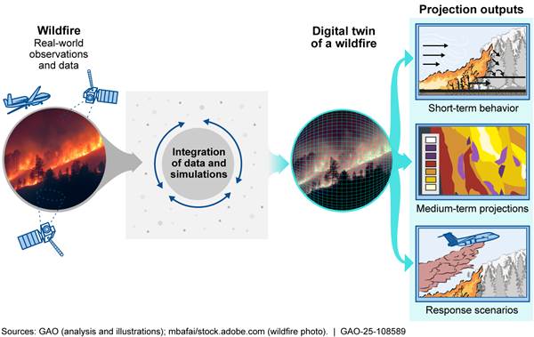
Digital twins are another ML tool in early development that could use the data collected by wildfire technologies to improve response. Digital twins are representations of physical processes, objects, or systems that rely on large amounts of data from real-world observations. Digital twins for wildfires could use near-real-time observations to make much faster and higher-resolution predictions (see fig. 2). For example, such a digital twin could help identify patterns of firefighting tanker plane deployment that might best slow the spread of a fire.
Figure 2: A Digital Twin Recreating a Wildfire
Despite the potential of ML for wildfire modeling, there are limitations. For example, historical data are limited for rare events, which may limit the utility of AI for forecasting extreme wildfires. There are limitations related to the detection accuracy of algorithms and incidence of false alerts. Research is ongoing to address these, in part by using localized data from past wildfires. In addition, ML could help some aspects of data use in modeling, but it also can require extensive up-front work to ensure the data are readily usable by ML. Pre-processing these data to make them “AI ready” can be costly and time consuming.
ML for wildfire modeling to inform forecasting, detection, and response efforts varies in maturity and level of use. As the field continues to develop, proper safeguards will be important to minimize the risk of conveying inaccurate or otherwise harmful information, which can cost lives and property. Having trained and experienced people to interpret the modeling results can be important as well. Some officials we spoke with during prior GAO work also emphasized the importance of having more long-term fire analysts assigned to national forests and incident management teams to help develop and interpret fire behavior models and long-term assessments that, in turn, could help protect people at risk.[10] Lastly, agencies may be hesitant to adopt models without more evidence they work, showing the importance of continued testing of such systems, including in operational environments.
In conclusion, current and emerging technologies—including satellites, aircraft and drones, cameras, sensors, and AI—can enhance the nation’s ability to forecast, detect, mitigate, and respond to wildfires. In addition to the potential benefits, we have also noted limitations and challenges associated with these technologies and offered options policymakers (government agencies, legislators, industry, academia, and others) could consider to help address them (see table 1).
Table 1. Selected Options for Policymaker Consideration
|
Expand use of existing observational data and infrastructure to close gaps and establish guidelines for making data AI-ready. |
|
Update education requirements to include ML-related coursework and expand learning and support centers. Adjust physical science curricula to include more ML coursework. |
|
Consider what combination of detection technologies could most cost-effectively maximize geographic coverage and manage wildfire risk. |
|
Consider how costs for wildfire detection technologies could be balanced with costs for fire prevention management, such as clearing vegetation. |
Source: GAO. | GAO-25-108589
However, technology does not exist in a vacuum, and its adoption and implementation are affected by many additional factors. In addition to the assessment of wildfire technologies and the use of AI that I am testifying on today, GAO has issued 12 reports in the last 10 years on related topics such as forest management, wildfire staffing, and interagency coordination on wildfire response (see appendix 1 for prior related GAO reports). In these reports, GAO has made 23 recommendations to agencies, 10 of which have been implemented. For example, as a result of a GAO recommendation, the Forest Service and Interior now have criteria for selecting and conducting reviews of past fires to assess the effectiveness of their response and potentially improve approaches.[11] However, 13 of our recommendations have not been fully addressed by agencies. For example, GAO has an open recommendation to the Forest Service to better measure the outcomes of its hazardous fuels program in reducing wildfire risk.[12] Implementing this recommendation may help the agency better assess the extent to which its prescribed fire program is achieving its goal of reducing wildfire risk.
Chairman Tiffany, Ranking Member Neguse, and Members of the Subcommittee, this completes my prepared statement. I would be pleased to respond to any questions that you may have at this time.
GAO Contacts and Staff Acknowledgments
If you or your staff have any questions about this testimony, please contact Karen Howard, Director, Science, Technology Assessments, and Analytics at HowardK@gao.gov. Contact points for our Offices of Congressional Relations and Public Affairs may be found on the last page of this statement. GAO staff who made key contributions to this statement are Laura Holliday (Assistant Director), Kristen Pinnock (Analyst-in-Charge), Jonathan Dent, Ryan Han, Jenique Meekins, and Ben Shouse. Also contributing were John Bauckman, Patrick Harner, Allison Henn, Anne Hobson, Claire McLellan, Katrina Pekar-Carpenter, Jim Rice, Atiya Siddiqi, Andrew Stavisky, and Arvin Wu.
Appendix I: Related GAO Products
Science & Tech Spotlight: Wildfire Detection Technologies. GAO‑25‑108161. Washington, D.C.: May 2025.
Wildfires: Additional Actions Needed to Address FEMA Assistance Challenges. GAO‑25‑106862. Washington, D.C.: December 18, 2024.
Federal Lands: Effects of Interior’s Policies on Foreign-Made Drones. GAO‑24‑106924. Washington, D.C.: September 25, 2024.
Forest Service: Fully Following Leading Practices for Agency Reforms Would Strengthen Prescribed Fire Program. GAO‑24‑106239. Washington, D.C.: June 5, 2024.
Technology Assessment: Air Quality Sensors: Policy Options to Help Address Implementation Challenges. GAO‑24‑106393. Washington, D.C.: March 2024.
Artificial Intelligence in Natural Hazard Modeling: Severe Storms, Hurricanes, Floods, and Wildfires. GAO‑24‑106213. Washington, D.C.: December 14, 2023.
Wildfire Smoke: Opportunities to Strengthen Federal Efforts to Manage Growing Risks. GAO‑23‑104723. Washington, D.C.: March 13, 2023.
Wildland Fire: Barriers to Recruitment and Retention of Federal Wildland Firefighters. GAO‑23‑105517. Washington, D.C.: November 17, 2022.
Wildfire: Information on Forest Service Response, Key Concerns, and Effects of the Chetco Bar Fire. GAO‑20‑424. Washington, D.C.: April 29, 2020.
Wildland Fire: Federal Agencies’ Efforts to Reduce Wildland Fuels and Lower Risk to Communities and Ecosystems. GAO‑20‑52. Washington, D.C.: December 19, 2019.
Disaster Resilience Framework: Principles for Analyzing Federal Efforts to Facilitate and Promote Resilience to Natural Disasters. GAO‑20‑100SP. Washington, D.C.: October 23, 2019.
Wildfire Disasters: FEMA Could Take Additional Actions to Address Unique Response and Recovery Challenges. GAO‑20‑5. Washington, D.C.: October 9, 2019.
Wildland Fire Risk Reduction: Multiple Factors Affect Federal-Nonfederal Collaboration, but Action Could Be Taken to Better Measure Progress. GAO‑17‑357. Washington, D.C.: May 10, 2017.
Wildland Fire Management: Agencies Have Made Several Key Changes but Could Benefit from More Information about Effectiveness. GAO‑15‑772. Washington, D.C.: September 16, 2015.
This is a work of the U.S. government and is not subject to copyright protection in the United States. The published product may be reproduced and distributed in its entirety without further permission from GAO. However, because this work may contain copyrighted images or other material, permission from the copyright holder may be necessary if you wish to reproduce this material separately.
The Government Accountability Office, the audit, evaluation, and investigative arm of Congress, exists to support Congress in meeting its constitutional responsibilities and to help improve the performance and accountability of the federal government for the American people. GAO examines the use of public funds; evaluates federal programs and policies; and provides analyses, recommendations, and other assistance to help Congress make informed oversight, policy, and funding decisions. GAO’s commitment to good government is reflected in its core values of accountability, integrity, and reliability.
Obtaining Copies of GAO Reports and Testimony
The fastest and easiest way to obtain copies of GAO documents at no cost is through our website. Each weekday afternoon, GAO posts on its website newly released reports, testimony, and correspondence. You can also subscribe to GAO’s email updates to receive notification of newly posted products.
Order by Phone
The price of each GAO publication reflects GAO’s actual cost of production and distribution and depends on the number of pages in the publication and whether the publication is printed in color or black and white. Pricing and ordering information is posted on GAO’s website, https://www.gao.gov/ordering.htm.
Place orders by calling (202) 512-6000, toll free (866) 801-7077,
or
TDD (202) 512-2537.
Orders may be paid for using American Express, Discover Card, MasterCard, Visa, check, or money order. Call for additional information.
Connect with GAO
Connect with GAO on X,
LinkedIn, Instagram, and YouTube.
Subscribe to our Email Updates. Listen to our Podcasts.
Visit GAO on the web at https://www.gao.gov.
To Report Fraud, Waste, and Abuse in Federal Programs
Contact FraudNet:
Website: https://www.gao.gov/about/what-gao-does/fraudnet
Automated answering system: (800) 424-5454
Media Relations
Sarah Kaczmarek, Managing Director, Media@gao.gov
Congressional Relations
A. Nicole Clowers, Managing Director, CongRel@gao.gov
General Inquiries
[1]For the purposes of this testimony, we are using the term wildfire to encompass fires in natural areas like forests, grasslands, and brushlands, whether unplanned and uncontrolled or intentionally set prescribed fires.
[2]These statistics represent billion-dollar events from 1980 through 2023 and are not representative of all wildfires that occur throughout the year across the U.S. See NOAA National Centers for Environmental Information, U.S. Billion-Dollar Weather and Climate Disasters (2023), https://www.ncei.noaa.gov/access/billions/summary-stats. According to NOAA, these costs include factors like physical damage to residential, commercial, and municipal buildings; material assets (content) within buildings; time element losses such as business interruption or loss of living quarters; damage to vehicles; public assets including roads and bridges; electrical infrastructure; agricultural assets including crops, livestock, and commercial timber; and wildfire suppression costs, among others.
[3]GAO, Science & Tech Spotlight: Wildfire Detection Technologies, GAO‑25‑108161 (Washington, D.C.: May 1, 2025); GAO, Federal Lands: Effects of Interior’s Policies on Foreign-Made Drones, GAO‑24‑106924 (Washington, D.C.: Sept. 25, 2024); GAO, Artificial Intelligence in Natural Hazard Modeling: Severe Storms, Hurricanes, Floods, and Wildfires, GAO‑24‑106213, (Washington, D.C.: Dec. 14, 2023).
[4]For more information about rules on flying drones near wildfires, see: https://www.faa.gov/sites/faa.gov/files/uas/resources/community_engagement/FAA_drones_wildfires_toolkit.pdf
[5]For more information see ALERTCalifornia, Technology, https://alertcalifornia.org/technology/, last accessed June 19, 2025.
[7]Amy L. DeCastro et al., “A Computationally Efficient Method for Updating Fuel Inputs for Wildfire Behavior Models Using Sentinel Imagery and Random Forest Classification,” Remote Sensing vol. 14, no. 6 (2022): 1-12, https://doi.org/10.3390/rs14061447.
[8]The Potential Control Locations model can also help agencies identify locations where reducing hazardous fuels could help reduce damage from future wildfires. See, GAO, Forest Service: Fully Following Leading Practices for Agency Reforms Would Strengthen Prescribed Fire Program, GAO‑24‑106239 (Washington, D.C.: June 5, 2024).
[9]LiDAR is a sensing technology that uses laser light to measure distance and construct detailed images of the environment.
[10]GAO, WILDFIRE Information on Forest Service Response, Key Concerns, and Effects of the Chetco Bar Fire, GAO‑20‑424, (Washington, D.C.: April 29, 2020).
[11]Wildland Fire Management: Agencies Have Made Several Key Changes but Could Benefit from More Information about Effectiveness. GAO‑15‑772. Washington, D.C.: September 16, 2015.
[12]Forest Service: Fully Following Leading Practices for Agency Reforms Would Strengthen Prescribed Fire Program. GAO‑24‑106239. Washington, D.C.: June 5, 2024.