
Report to Congressional Requesters
United States Government Accountability Office
A report to congressional requesters
Contact: Kevin Walsh at walshk@gao.gov.
What GAO Found
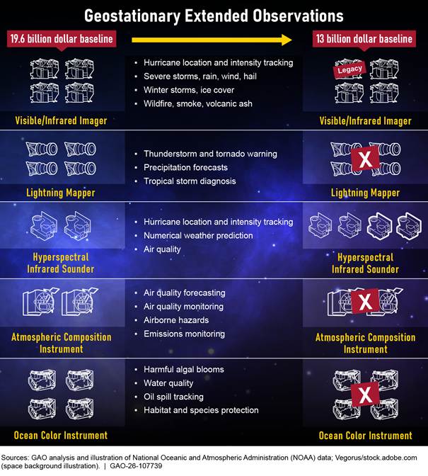
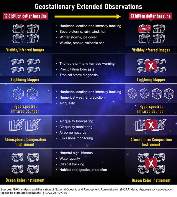
The National Oceanic and Atmospheric Administration (NOAA) initially planned for the Geostationary Extended Observations (GeoXO) program to be a series of six satellites with a projected lifecycle cost of $19.6 billion. In August 2025, Commerce directed the GeoXO program office to implement a major restructuring to reduce lifecycle costs, and in April 2026 Commerce approved the program’s new baseline. This new baseline reduces the number of satellites from six to four, decreases the number of instruments from five to two (see figure), and is expected to reduce the program’s lifecycle cost to $13 billion.
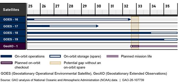
If the first GeoXO satellite launches as expected in 2032, there is a risk of a gap in the continuity of satellite data. NOAA’s policy requires at least two operational satellites and one operational spare to be available to ensure the continuity of data. The current spare satellite is projected to meet the end of its life in October 2032, several months before the first GeoXO satellite is fully operational. There may be a period of several months when NOAA does not have an operational spare satellite. If either of the two operational satellites were impaired during that time, there would be a gap in geostationary weather data (see figure).
The effects of the rebaseline add uncertainty to the program’s cost, schedule, and instrument configuration. For example, the program office has yet to complete an independent cost estimate for its updated cost baseline, so it is unclear whether the $13 billion estimate for the restructuring is reasonable.
GeoXO’s prior lifecycle cost estimate of $19.6 billion from 2022 partially met three and substantially met one of the best practices associated with a well-documented estimate. The gaps were due, in part, to the program’s lack of a separate narrative document that summarized the estimate and the methodology used. These gaps will make it difficult for GeoXO to replicate calculations and detect possible errors in the estimate and its ongoing revisions, and can undermine the ability to use the information to improve future cost estimates.
The GeoXO program fully incorporated selected leading practices related to requirements management in its policies and procedures, which was a lesson learned from previous weather satellite programs. However, the program did not fully incorporate leading practices for other lessons learned:
· Contingency planning: NOAA partially incorporated leading practices for contingency planning into its plans to address potential satellite availability gaps. Specifically, the plan was missing key elements, such as an impact analysis for potential failure scenarios and specific actions needed to implement all contingency strategies. Until NOAA incorporates the missing key elements, it may not be sufficiently prepared to mitigate potential gaps in geostationary weather satellite data, which would diminish its ability to track and monitor hazardous weather.
· Technology readiness: NOAA and the National Aeronautics and Space Administration (NASA) did not incorporate leading practices related to documenting the results of its process to assess the readiness of key new technologies. Specifically, the GeoXO program did not document its assessment of the readiness of key technologies for three new instruments and did not develop a comprehensive report with the results of this assessment, which is required by NASA guidance. Thus, whether the program has enough information to determine if a technology is sufficiently mature is unclear, which increases the risk of delay and cost overruns.
Why GAO Did This Study
Geostationary environmental satellites play a critical role in the nation’s weather forecasting. These satellites provide information on atmospheric conditions for monitoring Earth’s weather, including severe storms and hurricanes.
NOAA, a component of the Department of Commerce, through collaboration with NASA, is procuring the next generation of geostationary weather satellites, called GeoXO. GeoXO satellites are intended to replace the current series of geostationary environmental satellites as they reach the end of their useful lives. The GeoXO mission was planned to continue the vital observations provided by the existing operational geostationary satellites and bring new and improved capabilities.
GAO was asked to review the GeoXO program. This report addresses (1) the status of the GeoXO program, (2) the extent to which NOAA and NASA have implemented relevant best practices to establish cost estimates, and (3) the extent to which NOAA and NASA incorporated leading practices related to selected lessons learned from previous weather satellite programs into the development and organization of GeoXO program.
GAO analyzed agency documents, including program office plans, management reports, documentation supporting the program’s December 2022 cost estimate, contingency plans, requirements policies and procedures, and documentation that provided the results of the technical readiness assessments. GAO then compared this documentation against leading practices and interviewed agency officials.
What GAO Recommends
GAO is making three recommendations to Commerce to ensure that the GeoXO cost estimate incorporates best practices, contingency plans address weather data gaps and impacts of failure scenarios, and a complete technology readiness report is developed for each instrument. NOAA concurred with the recommendations.
Abbreviations
CMMI Capability Maturity Model Integration
GeoXO Geostationary Extended Observations
GOES Geostationary Operational Environmental Satellite
KDP key decision point
NASA National Aeronautics and Space Administration
NESDIS National Environmental Satellite, Data, and Information Service
NOAA National Oceanic and Atmospheric Administration
OIG Office of the Inspector General
TRA technology readiness assessment
ISACA Information Systems Audit and Control Association
This is a work of the U.S. government and is not subject to copyright protection in the United States. The published product may be reproduced and distributed in its entirety without further permission from GAO. However, because this work may contain copyrighted images or other material, permission from the copyright holder may be necessary if you wish to reproduce this material separately.
September 16, 2026
The Honorable Ted Cruz
Chairman
Committee on Commerce, Science, and Transportation
United States Senate
The Honorable Brian Babin
Chairman
The Honorable Zoe Lofgren
Ranking Member
Committee on Science, Space, and Technology
House of Representatives
The Honorable Frank Lucas
House of Representatives
Geostationary environmental satellites play a critical role in our nation’s weather forecasting. These satellites—which are managed by the Department of Commerce’s National Oceanic and Atmospheric Administration (NOAA)—provide information on atmospheric conditions for monitoring earth’s weather and environment, including severe storms, hurricanes, and natural hazards like wildfires, smoke, dust, volcanic ash, drought, and flooding.
NOAA, through collaboration with the National Aeronautics and Space Administration (NASA), is procuring the next generation of geostationary weather satellites, called the Geostationary Extended Observations (GeoXO) series. GeoXO is to replace the current series of geostationary environmental satellites as they reach the end of their useful lives. The GeoXO mission is expected to continue the vital observations provided by the existing operational geostationary satellites and bring new and improved capabilities for short-term forecasts and warnings of severe weather and environmental hazards.
Starting in 2025, NOAA began significant restructuring of the GeoXO program based on direction from Commerce to reduce program costs. The proposed changes include, among others, elimination of two (of six) satellites, and the removal of two climate-related instruments and an instrument intended to detect lightning during severe storms.
You asked us to review NOAA’s GeoXO program. This report (1) examines the status of the GeoXO program, (2) evaluates the extent to which NOAA and NASA have implemented relevant best practices to establish cost estimates, and (3) evaluates the extent to which NOAA and NASA incorporated leading practices related to selected lessons learned from previous weather satellite programs into the development and organization of the GeoXO program.
To address our first objective, we reviewed various program office plans and management reports such as the GeoXO program management plan; concept of operations; risk management plan; briefing slides from monthly program updates, milestone reviews (e.g., the Preliminary Design Review), and agency-level reviews; monthly risk registers; and a rebaseline memo from Commerce. Furthermore, we interviewed NOAA and NASA officials from the GeoXO program office to determine key dates for future efforts and milestones, and potential changes in program scope, cost, and schedule.
To address our second objective, we compared GeoXO cost documentation against relevant cost estimating best practices identified by our Cost Estimating and Assessment Guide.[1] This guide describes the four characteristics of a high-quality, reliable cost estimate—comprehensive, well-documented, accurate, and credible. Given the ongoing restructuring of the GeoXO program, the 2022 baseline cost estimate is less relevant to the future of the program. Accordingly, we conducted an abridged analysis, focusing on the well-documented characteristic. This allowed us to assess practices that will likely be employed in future updates to the cost baseline. We reviewed and analyzed cost documentation supporting the GeoXO life cycle cost estimate from December 2022. This documentation included the program’s automated cost estimator model, cost analysis data requirements documentation, and documentation of the cost estimate provided for the program’s systems requirements review.
To address our third objective, we analyzed our past body of work on NOAA’s geostationary and polar-orbiting weather satellite acquisitions to identify lessons learned. We then selected lessons that we determined were most relevant for our scope based on the current status of development for the program. We selected the following lessons learned:
· developing contingency plans to mitigate the risk of gaps in satellite data continuity,
· ensuring that requirements are developed and managed appropriately, and
· ensuring sufficient technical readiness of system components.
For each of the three areas, we assessed the evidence against selected best and leading practices to determine whether each program fully, partially, or did not meet the practices. We also interviewed NOAA and NASA officials. A detailed discussion on our objectives, scope, and methodology is provided in appendix I.
We conducted this performance audit from August 2024 to September 2026 in accordance with generally accepted government auditing standards. Those standards require that we plan and perform the audit to obtain sufficient, appropriate evidence to provide a reasonable basis for our findings and conclusions based on our audit objectives. We believe that the evidence obtained provides a reasonable basis for our findings and conclusions based on our audit objectives.
Background
|
Types of Weather Satellites The United States relies on two complementary types of satellite systems for weather observations and forecasts: 1. Polar-orbiting satellites provide a global perspective every morning and afternoon at a low earth orbit. These satellites provide the data that go into numerical weather prediction models, which are a primary tool for forecasting weather days in advance—including forecasting the path and intensity of hurricanes. 2. Geostationary satellites maintain a fixed view of the United States at approximately 22,300 miles above the earth. These satellites provide the graphical images used to identify current weather patterns, provide short-term severe warnings, and detect wildfires. Source: GAO summary of National Oceanic and Atmospheric Administration (NOAA) documentation. | GAO‑26‑107739 |
Since the 1970s, the United States has used geostationary satellites to provide meteorological data for weather observation, research, and forecasting. NOAA’s National Environmental Satellite, Data, and Information Service (NESDIS) is responsible for acquiring next-generation earth and space weather observation satellites. See appendix II for more details on NOAA’s weather satellite programs.
Among these satellite programs, NESDIS manages the set of satellites called Geostationary Operational Environmental Satellite (GOES).[2] NOAA operates GOES as a two-satellite system that is primarily focused on the United States (see figure 1). These satellites provide timely environmental data about the earth’s atmosphere, surface, cloud cover, and the space environment to meteorologists and their audiences. They also observe the development of hazardous weather, such as hurricanes and severe thunderstorms, and track their movement and intensity to reduce or avoid major losses of property and life. Each of the operational geostationary satellites continuously transmits raw environmental data to NOAA ground stations. The data are processed at these ground stations and transmitted back to the satellite for broadcast to primary weather services and the global research community in the United States and abroad. The ability of the satellites to provide broad, continuously updated coverage of atmospheric conditions over land and oceans is important to NOAA’s weather forecasting operations.
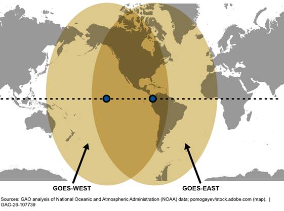
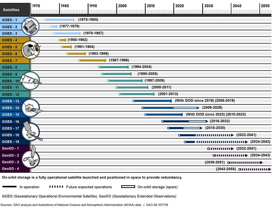
NOAA’s policy is to always have two operational satellites and one backup satellite in orbit. The most recent generation of four GOES satellites (referred to as GOES-16, GOES-17, GOES-18, and GOES-19) were launched over an 8-year span from November 2016 to June 2024. These satellites carry two instruments designed to observe the earth and four to observe space weather.[3] The two earth-observing instruments are:
· The Advanced Baseline Imager is the primary instrument, which takes images of the earth across both the visible and infrared spectrums. The imager tracks and monitors cloud formation, land surface temperature, fire, and air quality. The imager’s data enables meteorologists to pinpoint and track developing storms in much greater detail.
· The Geostationary Lightning Mapper is a near-infrared detector that monitors for the momentary changes in light emitted by lightning. Developing severe storms often exhibit a significant increase in lightning activity, frequently many minutes before radar detects the potential for severe weather. Accordingly, data from the lightning mapper increases lead time for severe thunderstorm and tornado warnings. Notably, this is the first-ever operational lightning mapper flown in geostationary orbit.
The GOES-18 and GOES-19 satellites are the current generation of operational geostationary environmental satellites over the United States which are expected to be replaced by the GeoXO series of satellites. Critically, the first GeoXO launch is planned for 2032 to ensure continuity of observations from geostationary orbit as the prior generation nears the end of its operational lifetime. See figure 2 for a timeline of the current and future geostationary environmental satellites of the United States.
Overview of the GeoXO Program
The GeoXO weather satellite program is the next generation of GOES. GeoXO is intended to improve the GOES observations for weather forecasting and extend observations to include ocean, coasts, and atmospheric monitoring. The program includes:
· satellites that host earth-observing instruments,
· ground segment command and control,
· a signal relay capability to transmit data to earth, and
· data processing and distribution capabilities.
When it was established in 2021, GeoXO was expected to provide two broad classes of benefits: (1) continuation of current geospatial observing capabilities from GOES-series satellites and (2) enhanced observational capabilities. For example, this initial design of GeoXO included an infrared imager with four times the resolution of the Advanced Baseline Imager on GOES. Additionally, the initial design of GeoXO included a hyperspectral infrared sounder, an instrument currently on NOAA’s polar-orbiting satellites.[4] While polar-orbiting satellites provide infrared sounder observations twice daily, placing the instrument on the GeoXO satellites could provide continuous observations.
After launch, the GeoXO program intends to hand over the satellites to NOAA’s Office of Satellite and Product Operations for routine operations. This office will operate the satellites from the ground system that was developed for the GOES satellites and will be upgraded for GeoXO. The continuous real-time data from the satellites will be provided to users via the cloud and, for some users, via commercial broadcast.
GeoXO is managed as a joint NOAA-NASA program. The program is led by NOAA, with staff from both agencies supporting the program office. NOAA provides the program director, science and program control leads, and the ground project manager. NASA provides the deputy program director, the systems engineering and mission assurance leads, and the flight project manager. NASA’s Goddard Space Flight Center leads the acquisitions process for the spacecraft and instruments.
NOAA and NASA Space System Life Cycle for GeoXO
The GeoXO program follows a tailored version of NASA’s standard space system life cycle that includes requirements from Commerce’s acquisition guidance. This life cycle includes distinct phases, including concept and technology development; preliminary design and technology completion; final design and fabrication; system assembly, integration and testing, and launch; and operations and sustainment.
This tailored approach includes management decision reviews at various stages of formulation and implementation. NOAA and NASA jointly conduct management reviews (called key decision point (KDP) reviews and milestone reviews) on the program and individual projects to determine whether to proceed to the next phase. For example, prior to milestone 2, the tailored life cycle calls for GeoXO to generate an integrated master schedule and detailed program cost estimate. As another example, formulation culminates in a review at KDP C, at which point senior leaders determine whether and how the project proceeds into the next phase and approves any additional actions. Figure 3 provides an overview of the life cycle phases and decision reviews for the GeoXO program.
Figure 3: National Oceanic and Atmospheric Administration (NOAA) and National Aeronautics and Space Administration’s (NASA) Life Cycle for the Geostationary Extended Observations Program
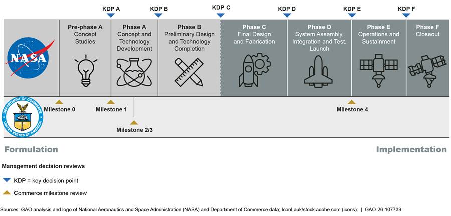
The program conducts other reviews throughout each of the phases, including preliminary design review, critical design review, and system integration review. For example, during phase A, the program reviews system requirements and definitions. These reviews help to ensure that the project’s proposed design remains aligned with the mission’s performance requirements.
Lessons Learned from Prior Environmental Satellite Programs
We have issued a series of reports aimed at addressing weaknesses in prior GOES programs.[5] The reports focused on (1) addressing cost risks, (2) technical readiness issues, (3) requirements management, and (4) contingency plans.
Addressing cost risks: In June 2012, we reported that the GOES program might not have been able to ensure that it had adequate resources to cover unexpected problems during development.[6] We recommended the program strengthen its process for planning and reporting on reserves. In response, the GOES program expanded its reporting of contingency reserve information.
In September 2013, we reported on weaknesses in the process for reporting reserves to management and recommended that NOAA take action to brief senior executives on a regular basis regarding the status of reserves.[7] NOAA agreed and addressed this recommendation by identifying needed reserve levels and providing a more detailed breakdown of reserve percentage calculations.
Technical readiness issues: In September 2006, we reported that the GOES program had experienced technical problems on the development of the imager, due in part to design complexity.[8] However, we also found that NOAA did not have a process to analyze and validate the level of technical maturity on the imager, and recommended it perform such an analysis. NOAA agreed with recommendation. The program subsequently addressed it and validated that the instrument’s design was robust and mature enough to enter the production phase.
However, the GOES technical challenges persisted. In 2012, we reported that key instruments were experiencing technical challenges and required additional redesign efforts.[9] For example, the ground project was experiencing ongoing technical problems related to the definition of ground system software requirements and integration of flight instruments, among other things. As a result, revisions were made to the ground system’s baseline development plan and schedule.
Requirements management: In September 2013, we reported that NOAA made changes to several of the GOES requirements—including decreasing the accuracy requirement for the hurricane intensity product and decreasing the timeliness of the lightning detection product—and that end users were concerned by many of these changes.[10] We recommended that the program improve communications with users on changes in GOES requirements by assessing impacts, seeking input from users, and disseminating information on changes. NOAA agreed and addressed this recommendation by disseminating information on past and potential changes in requirements to satellite data users through, among other things, presentations, training sessions, and conferences.
More recently in 2022, the Commerce Office of the Inspector General (OIG) reported on weaknesses in NOAA’s requirements management practices.[11] For example, the OIG found that NOAA’s process for validating user observation requirements is not adequate for next-generation satellite programs’ needs. The OIG made several recommendations to NOAA to improve these practices.
Contingency planning: In September 2010, we reported that it was possible that there would be a gap in geostationary satellite coverage because NOAA had to delay key program milestones, including the launch dates for the two satellites.[12] We also reported that NOAA had not established adequate continuity plans for its geostationary satellites. Thus, we recommended that NOAA develop and document continuity plans for geostationary satellites that include key information including implementation procedures, resources, staff roles, and timetables. The agency agreed with the recommendation. NOAA addressed this recommendation by developing a continuity plan that generally included these elements.
In February 2013, due to the importance of environmental satellite data and the potential for a gap in this data, we added mitigating weather satellite gaps to our biennial High Risk list.[13] In that report, we noted that NOAA had established a contingency plan for a potential gap in the GOES program, but it needed to demonstrate its progress in conducting training and simulations for contingency operations scenarios, and evaluating the status of viable foreign satellites, among other things. We also stated that NOAA should update its contingency plan to provide more details on its contingency scenarios, associated time frames, and any preventative actions it is taking to minimize the possibility of a gap.
In September 2013, we reported that, while NOAA had established contingency plans for the loss of the GOES satellites, these plans still did not address user concerns over potential reductions in capability and did not identify alternative solutions and timelines for preventing a delay in the satellite launch date.[14] We recommended the agency revise the satellite and ground system contingency plans to address weaknesses, including providing more information on the potential impact of a satellite failure and coordinating with key external stakeholders on contingency strategies. The agency agreed with this recommendation and addressed it by identifying and refining program contingency plans. Due in part to these actions, in 2019 we removed the Mitigating Gaps in Weather Satellite Data from our High Risk list.[15]
The issue of contingency planning was highlighted by a March 2026 report published by the Commerce OIG about the GeoXO program. The OIG reported that NOAA needs to better manage the risk of a geostationary satellite data continuity gap.[16] Specifically, the OIG found that GeoXO had not yet formalized plans to address the risk of a gap in geostationary data. As a result, the OIG recommended that NOAA take actions to evaluate alternatives to address this risk and escalate the risk to an enterprise risk board.
GeoXO Restructuring Continues Amidst Uncertainty
When established in 2021, NOAA planned for GeoXO to be a series of six satellites operated three at a time. In particular, GeoXO was expected to have satellites at three locations: East and West, which are similar to the current GOES satellite locations, and a third Central location roughly in the middle of the continental United States. The satellites were expected to improve upon the prior generations’ imagery and lightning mapping capabilities. They were also to include new instruments providing nighttime imagery, hyperspectral sounding, and information on atmospheric and oceanic conditions. However, unlike the prior generation, GeoXO planned to exclude the space weather instrumentation. In total, the program was expected to include five weather and climate instruments (see table 1), with each satellite including two or three of the instruments.[17]
Table 1: Planned Instruments for the Geostationary Extended Observations Program, as of February 2025
|
Instrument |
Description |
|
Atmospheric Composition |
Expected to measure ozone, nitrogen dioxide, and other pollutants used to determine forecasts and warnings of national air quality, hazard, and fire smoke. Data from this instrument was to provide the first operational capability to monitor air quality over North America on hourly time scales. These data would then drive forecasts and warnings issued by the Environmental Protection Agency and National Oceanic and Atmospheric Administration (NOAA). |
|
Hyperspectral Infrared Sounder |
Expected to provide data that will be used to produce routine meteorological analyses and forecasts of temperature, moisture, and winds for severe weather events. The sounder data products also provide real-time information to the National Weather Service forecasters to improve their ability to issue watches and warnings for severe weather including hurricanes. NOAA expects this instrument to measure infrared wavelengths across over 1,550 bands, compared to prior sounders which could monitor 18 bands. Data from this sounder is expected to increase full atmosphere sensing over the United States by 10 times compared to existing satellites, which will improve storm tracking, storm strength monitoring, and forecasting of fire behavior and smoke transport. |
|
Infrared Imager |
Expected to provide environmental data and imagery for weather and hazard forecasting, including severe weather warning. It would also provide continuity for Geostationary Operational Environmental Satellite (GOES) imagery data and products. Data from imagers are used for short-range weather forecasting, severe weather watches and warnings, and monitoring hazardous environmental conditions including tropical storms, severe storms with lightning and damaging winds, snow, ice, flooding, fog, fires, smoke, and volcanic ash. NOAA expects this imager to improve upon prior capabilities by viewing the earth across 18 spectral channels (an increase of two), while also improving the resolution of seven channels. According to NOAA, these upgrades will provide more precise observations and improve water vapor measurements. |
|
Lightning Mapper |
Expected to provide tracking of lightning in a storm cell to improve lightning hazard information and storm warnings and provide continuity for the lightning mapper data from GOES satellites. The lightning mapper was also expected to help with weather forecasting and provide the aviation community the ability to avoid cloud-to-cloud lightning. |
|
Ocean Color |
Expected to collect imagery of the earth’s coastal waters for harmful algal blooms, water turbidity, and general water quality. The ocean color instrument was also expected to monitor dynamic coast/ocean features, ecosystem change, and other hazards. |
Source: GAO analysis of NOAA data. | GAO‑26‑107739
From 2021 to 2025, the program made progress in determining the scope of the program, awarding contracts, and completing mission reviews. Specifically, the program completed KDP A in July 2021 and milestone 1 in October 2021.[18] In December 2022, the program completed milestones 2 and 3[19] and Commerce approved the program’s initial baseline scope, schedule, and cost of $19.6 billion. As of October 2024, the program had awarded contracts for the planned instruments and the spacecraft.
In February 2025, the GeoXO program completed development of its concept and technology (known as KDP B). In doing so, the program proposed a system design and demonstrated that the system could fulfill the mission objectives within existing constraints. Notably, at KDP B, GeoXO program officials considered deferring the development of the Hyperspectral Infrared Sounder, Ocean Color, and Atmospheric instruments to address budget uncertainty. The program also discussed multiple options for descoping instruments and the Central satellites.
Subsequently, the program has undergone significant cost and scope changes. In August 2025, Commerce directed the GeoXO program office to reduce life cycle costs by more than $7 billion. Accordingly, the program reduced the number of satellites from six to four and descoped three of the five planned instruments. In April 2026, Commerce directed the GeoXO program office to make additional changes to instrument configuration and life cycle costs. A summary of the changes follows:
· Program costs and contracts: In August 2025, Commerce directed the program to reduce life cycle costs from $19.6 billion to $12 billion, with a yearly maximum of $500 million. In April 2026, Commerce directed the program to increase life cycle cost by approximately $1 billion to accommodate an expanded payload scope and accelerated schedule. Further, according to program officials, the department directed the program to convert most of its contracts from cost-reimbursement to a fixed-price type.[20] This includes contracts for the spacecraft, imager, and most of the sounders.[21] GeoXO developed requests for proposal for these contract revisions in late August and early September 2025. As of April 2026, these contract modifications are still in process and program officials expect to have them completed before October 2026.
· Satellite numbers and locations: The August 2025 restructuring and subsequent modification reduced GeoXO from six satellites to four: two East satellites (expected to be launched in 2034 and 2043) and two West satellites (expected to be launched in 2032 and 2039). The two Central satellites were removed.
· Three descoped instruments: The program descoped the Lightning Mapper, Ocean Color instrument, and the Atmospheric Composition instrument. The program considered including a legacy lightning mapper but ultimately determined that it would unacceptably increase cost and technical risk. As of May 2026, the contracts for these instruments are in the process of being terminated. According to program officials, the termination costs for ocean color and atmospheric composition instruments are expected to be approximately $5 million.
· Updated imager delayed: The first GeoXO satellite (GeoXO-1) is expected to include a legacy Advanced Baseline Imager from the prior generation GOES satellite program, instead of a new imager. Subsequent satellites are expected to include a new imager.
· Accelerated sounder: The Hyperspectral Infrared Sounder instruments, originally planned for the Central location, are now expected to be on all four GeoXO satellites. This will entail accelerating development to include a sounder on the first satellite to meet the 2032 launch date.
According to program officials, in fiscal year 2026, GeoXO received an additional $113 million, which they plan to use to accelerate the development of the sounder. The program is currently performing an engineering analysis for the placement of the sounder on the first satellite. In addition, program officials reported that the existing contract includes three sounders. The decision on procuring a fourth sounder will consider the on-orbit performance of the first sounder.
In April 2026, Commerce directed the acceleration of the additional sounding capability and increased the program’s life cycle costs by $1 billion.
See table 2 and figure 4 for a summary of changes to GeoXO.
|
Characteristics |
Original baseline |
Proposed restructuring |
Current baseline |
|
Number of satellites |
6 |
4 |
4 |
|
Expected life cycle program cost |
$19.6 billion |
$12 billiona |
$13 billiona |
|
Expected launch dates and locations |
GeoXO-1: 2032 – West |
GeoXO-1: 2032 – West |
GeoXO-1: 2032 – West |
|
Atmospheric Composition |
On Central satellites |
Descoped |
Descoped |
|
Hyperspectral Infrared Sounder |
On Central satellites |
On GeoXO-2 and 4 |
On all satellitesb |
|
Infrared Imager |
On East and West satellites |
On all satellites, with a legacy instrument on GeoXO-1 |
On all satellites, with a legacy instrument on GeoXO-1 |
|
Lightning Mapper |
On East and West satellites |
Legacy instrument on GeoXO-1 Descoped on GeoXO-2, 3, and 4 |
Descoped |
|
Ocean Color |
On East and West satellites |
Descoped |
Descoped |
|
Additional payload |
On Central satellites, payload was to be determined |
Descoped |
Descoped |
Source: GAO analysis of National Oceanic and Atmospheric Administration data. | GAO‑26‑107739
aThe program plans to update the integrated master schedule and cost estimate by December 2026.
bProgram officials reported that they would need a contract modification in order to include a fourth sounder.
In April 2026, Commerce directed the program to prepare and submit a baseline report to Congress outlining the full mission scope by no later than December 31, 2026. As of April 2026, the program anticipated finishing its preliminary design and completing the detailed design of the system (known as KDP C) in the third quarter of 2028. See table 3 for a comparison of how GeoXO’s dates have changed.
Table 3: Comparison of Expected Milestone Dates for the Geostationary Extended (GeoXO) Observations Program, as of April 2026
|
Milestone |
Description |
Original baseline (December 2022) |
Current baseline (April 2026)a |
|
Key decision point (KDP)-A |
Approval to transition to concept and |
July 2021 |
|
|
Milestone 1 |
Approval results in agreement on analysis to identify gaps between existing and required capabilities to meet those mission needs, and that the proposed capabilities will close that gap |
November 2021 |
|
|
KDP- Delta A |
Approval to proceed to establish programmatic baseline |
October 2022 |
|
|
KDP-B |
Completed development of its concept and technology |
February 2025 |
|
|
Milestone 2 |
Approval results in agreement on the approach to executing the program, including acquisitions that will drive the program |
December 2022 |
April 2026b |
|
Milestone 3 |
Approval gives the program authority to enter production |
December 2022 |
April 2026b |
|
KDP-C |
Approval to begin implementation and baselines the project’s official schedule and budget |
Quarter 1 2027 |
Quarter 3 2028 |
|
GeoXO-1 launch |
Launch of first satellite |
2032 |
2032 |
|
GeoXO-2 launch |
Launch of second satellite |
2035 |
2034 |
|
GeoXO-3 launch |
Launch of third satellite |
2035 |
Descoped |
|
GeoXO-4 launch |
Launch of fourth satellite |
2039 |
2039c |
|
GeoXO-5 launch |
Launch of fifth satellite |
2040 |
Descoped |
|
GeoXO-6 launch |
Launch of sixth satellite |
2042 |
2043c |
Source: GAO analysis of National Oceanic and Atmospheric Administration data. | GAO‑26‑107739
aThe program has not yet updated milestone dates with the restructuring of the program. Thus, these dates are subject to change.
bThe program originally held Milestones 2 and 3 in December 2022 but repeated these milestones in April 2026 due to the restructuring of the program.
cDue to the restructuring of the program, the 2039 launch was renamed to GeoXO-3 and the 2043 launch was renamed to GeoXO-4.
With the expected launch date of GeoXO-1 in 2032, there is a risk of a gap in the continuity of geostationary satellite data.[22] Specifically, the current operational spare satellite (GOES-16) is projected to meet the end of its life in October 2032. However, the replacement for GOES-18 (GeoXO-1) is not expected to become operational until early 2033, after launch and a few months of on-orbit testing. In other words, there may be a period of several months when NOAA does not have an operational spare satellite. If something during that time impaired either of the two operational satellites (GOES-18 or GOES-19) there would be a gap in geostationary weather data.[23] Furthermore, NOAA’s policy for the program requires at least two operational satellites and one operational spare to be available to ensure the continuity of weather satellite data. Figure 5 depicts the potential gap in data continuity.
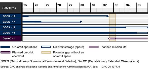
This potential gap assumes that GeoXO-1 launches on time. However, the ongoing program restructuring exacerbates risk and uncertainty to the program:
· Schedule uncertainty: In April 2026, the program office updated its baseline schedule. Program officials reported that disruptions in funding could affect the schedule and the 2032 launch, which could increase the risk to geostationary data continuity.
· Cost uncertainty: The program office has yet to complete an independent cost estimate for its updated cost baseline, so it is unclear whether the $13 billion estimate for the proposed restructuring is reasonable. Furthermore, the changes to the program introduce uncertainty in the ability of it to meet the $13 billion cost estimate. For example, according to the program, costs for the imager and sounder could be higher due to the change from cost-reimbursement to a fixed-price contract type. The program is tracking this as a medium risk.
· Instruments: Accelerating the development of the sounder is likely to have cost, schedule, and performance implications.
GeoXO Partially Implemented Best Practices for Documenting Its Cost Estimate
According to GAO’s Cost Estimating and Assessment Guide, well-documented cost estimates can easily be repeated or updated and can be traced to original sources through auditing.[24] Thorough documentation explicitly identifies the primary methods, calculations, results, rationales or assumptions, and sources of the data used to generate each cost element’s estimate.
GeoXO’s December 2022 estimate of $19.6 billion[25] partially met three and substantially met one of the best practices associated with a well-documented estimate.[26] See table 4 for more details.
Table 4: Summary Assessment of Geostationary Extended Observations (GeoXO) December 2022 Cost Estimate Compared to the Well-documented Characteristic
|
Selected best practice |
Assessment |
Rationale |
|
The cost estimate documentation shows the source data used, the reliability of the data, and the estimating methodology used to derive each element’s cost. |
◐ |
The documentation identified source data, methods used, and assessments of the reliability of the data. However, the data for many important cost elements—such as the spacecraft and payload costs—were not fully documented. Further, the lack of a single narrative document made tracing the documentation contained within the various estimate artifacts time-consuming and difficult. Without sufficient background knowledge about the source and reliability of the data, the cost estimator cannot know with any confidence whether the data collected can be used directly or need to be modified. |
|
The cost estimate documentation describes how the estimate was developed so that a cost analyst unfamiliar with the program could understand what was done and replicate it. |
◐ |
The documentation described the estimate with narrative and cost tables. Also, the documentation addressed the guidance used to govern the creation, maintenance, structure, and status of the cost estimate. However, there were elements of the estimating methodology that were not fully documented. For example, explanations for the logic behind some of the decisions for the estimate were missing. In addition, the available documentation provided only a limited description of the risk and uncertainty analysis. Without adequate documentation, an analyst unfamiliar with the program will not be able to replicate the estimate because they will not have enough information to recreate it step by step. |
|
The cost estimate documentation discusses the technical baseline description and the data in the technical baseline are consistent with the cost estimate. |
◕ |
The data used for the cost estimate largely tracked with the technical documentation for GeoXO. However, there were some disconnects between the cost model and the technical documentation related to launch vehicles and payload and instrument technical characteristics. |
|
The cost estimate documentation provides evidence that the cost estimate was reviewed and accepted by management. |
◐ |
Briefings to management included a time-phased version of the cost estimate in both table and graphical formats, ground rules and assumptions, and a conclusion that sufficient resources exist to execute the program. However, the briefings did not include a presentation of the estimate in constant year dollars; discussion of estimating methods, data sources, sensitivity analysis, and cost drivers; and comparison with an independent cost estimate. There was also minimal discussion of concerns and challenges and there was no indication of what feedback was received from management and how that was addressed. If management is not presented with sufficient information about how the estimate was constructed—including the specific details about the program’s technical characteristics, assumptions, data, cost estimating methodologies, sensitivity, and risk and uncertainty—management will not have confidence that the estimate is complete and high in quality. |
Legend: ● – Met; ◕ – Substantially Met; ◐ – Partially Met; ◔ – Minimally Met; ○ – Not Met; N/A – Not Applicable
Source: GAO analysis of National Oceanic and Atmospheric
Administration (NOAA) documentation. | GAO‑26‑107739
The gaps in the cost estimate documentation were due, in part, to the program’s lack of a separate narrative document that would provide a summary description of the estimate and the methodology used. Documentation for the estimate was found in several other locations; however, this documentation was incomplete. According to program officials, there are no plans to create a separate narrative document.
The ongoing restructuring of the GeoXO program reduced the relevance of its 2022 cost estimate. However, these gaps in documentation will make it difficult for GeoXO to replicate calculations and detect possible errors in the estimate and its ongoing revisions. Further, the lack of detail reduces transparency of the estimation process and can undermine the ability to use the information to improve future cost estimates or reconcile the estimate with another independent effort.
NOAA and NASA Incorporated Many Selected Lessons Learned Into the Development of GeoXO
NOAA and NASA incorporated many selected lessons learned into the development of GeoXO. Specifically, NOAA and NASA fully incorporated selected leading practices for requirements management in the GeoXO policies and procedures. In addition, NOAA incorporated most leading practices for contingency planning into its plans to address potential satellite availability gaps. However, NOAA and NASA did not incorporate leading practices related to documenting its process to assess the readiness of new technologies.
NOAA Policies and Procedures Fully Incorporated Selected Leading Requirements Management Practices
The Information Systems Audit and Control Association’s (ISACA®) Capability Maturity Model Integration (CMMI®) Model 3.0 details five leading practices for managing requirements.[27] As of September 2025, NOAA’s policies and procedures for requirements management for the GeoXO program fully incorporated all five leading practices, as shown in table 5.
Table 5: Extent to Which National Oceanic Atmospheric Administration’s (NOAA) Guidance for the Geostationary Extended Observations (GeoXO) Program Incorporated Selected Leading Practices for Requirements Management
|
Practice |
Assessment |
Rationale |
|
1. Elicit stakeholder needs, expectations, constraints, and interfaces or connections |
● |
NOAA’s guidance described the process for gathering stakeholder needs, expectations, constraints, and interfaces. Specifically, NOAA’s National Environmental Satellite, Data, and Information Service (NESDIS) Office of Systems Architecture and Advanced Planning gathered input from both internal and external sources, including from applicable laws, Department of Commerce policy directives, the NOAA Observing Systems Council, and data users. In addition, the guidance called for the GeoXO Satellite User Needs Working Group to develop a strategy for including input from stakeholders into requirements. Once a request is approved, the NESDIS Assistant Administrator is expected to establish a team to complete an initial impact assessment of these stakeholder needs to determine if the request is feasible. |
|
2. Translate stakeholder needs, expectations, constraints, and interfaces or connections into prioritized customer requirements |
● |
NOAA’s guidance called for the NESDIS Requirements Management Board to formulate high-level requirements derived from the stakeholder needs that were collected. The guidance also called for the GeoXO Satellite User Needs Working Group to review the requirements and prioritize them. GeoXO stakeholder needs and priorities were also discussed at review meetings in alignment with the guidance. For example, the National Weather Service is the primary stakeholder for GeoXO and it participated in requirements prioritization at management meetings such as monthly status reviews. |
|
3. Obtain commitment from project participants that they can implement the requirements |
● |
NOAA’s guidance called for the Requirements Management Board to validate requirements against stakeholder expectations, mission objectives and constraints, the operational objectives, and the mission success criteria. In addition, the guidance called for the board to identify an approach for verifying the requirements, such as creating a verification matrix for each requirement. The board is also expected to develop impact assessments that include analyses of alternatives for the requirements and rough cost and schedule estimates. |
|
4. Develop, record, and maintain bidirectional traceability among requirements and activities or work product |
● |
GeoXO’s guidance called for all lower-level requirements to be traceable directly from higher-level requirements. The program documented all GeoXO requirements and associated traceability in the program’s requirements database tool. The tool is also used to manage and track requirements change requests. Officials also developed analyses of recursive traceability and these analysis samples are stored within the database tool. |
|
5. Ensure that plans and activities or work products remain consistent with requirements |
● |
GeoXO’s guidance called for the program systems engineer to be responsible for ensuring the system meets the defined mission-level requirements. The guidance also called for program system engineers to assess the impacts of changes to requirements to ensure they do not impact the system’s ability to achieve overall mission objectives. Requirements changes are expected to be reviewed by the Engineering Change Review Board and the Configuration Control Board and then documented in the requirements database tool. |
Legend: ● – Met; ◐ – Partially Met; ○ – Not Met; N/A – Not Applicable
Source: GAO analysis of NOAA documentation. | GAO‑26‑107739
As a result of the GeoXO program fully incorporating all five leading practices for requirements management, the program has helped ensure consistency between the requirements and the solution, which increases the likelihood that the solution will meet mission needs. With properly developed requirements management guidance, the GeoXO program is in a better position to effectively meet its mission.
NOAA Incorporated Most of the Selected Leading Contingency Planning Practices
To maintain an organization’s essential functions in the case of an adverse event, government and industry leading practices call for organizations to identify potential failure scenarios and impacts, and develop contingency plans.[28] To do so, organizations should implement 11 practices such as defining failure scenarios, conducting impact analyses, establishing resumption priorities, identifying and selecting strategies to address failure scenarios, defining roles and responsibilities, and having stakeholders review and approve contingency plans.
GeoXO program officials stated that the program uses NOAA’s March 2023 Geostationary Earth Orbit Launch and Spare Call-Up Policy[29] as its contingency plan. The purpose of this policy is to ensure the continuity of critical geostationary satellite data by identifying alternative approaches to mitigate risks to geostationary satellite systems during events that threaten to interrupt satellite weather data availability.
This policy fully incorporated eight of 11 leading contingency planning practices, partially incorporated two of them, and did not incorporate one. Table 6 provides a more detailed assessment of the extent to which the data gap mitigation policy incorporated leading contingency planning practices.
Table 6: Extent to Which National Oceanic and Atmospheric Administration’s (NOAA) Geostationary Data Gap Mitigation Policy Incorporated Leading Practices
|
Contingency planning practice |
Assessment |
Rationale |
|
Define likely failure scenarios |
● |
The policy identified failure scenarios such as development issues or delays, launch failures, on-orbit anomalies or failures, and on-orbit operations beyond expected lifetimes. |
|
Conduct impact analyses showing impact of failure scenarios on business processes |
○ |
The policy did not include an impact analysis detailing the anticipated impacts of the likely failure scenarios. |
|
Define minimum acceptable level of outputs and recovery time objectives |
● |
The policy identified a maximum time to restore that is not to exceed 3 weeks and defines recovery time objectives for data for both high-availability products and non-high-availability products. |
|
Establish resumption priorities |
● |
The policy identified key performance parameters and high availability products as the restoration priority. |
|
Define roles and responsibilities for implementing contingency plans |
● |
The policy identified data gap mitigation roles, responsibilities, and actions across NOAA, NASA, and other partners. |
|
Identify alternative solutions to address failure scenarios |
● |
The policy identified a number of solutions to address failure scenarios, including maintaining at least one operational on-orbit spare within the geostationary satellite constellation, developing plans and procedures to deploy a call-up spare satellite in the event that data quality from key performance parameters or high-availability products is interrupted, significantly degraded, or if either product completely fails; and negotiating reciprocal back-up arrangements with international partners as needed to ensure availability of key performance parameters and high-availability product observations. |
|
Select contingency strategies from among alternatives based on costs, benefits, and impacts |
◐ |
As of April 2026, it was unclear the degree to which the contingency strategies outlined in the policy were selected among alternatives based on costs, benefits, and impacts. According to NOAA officials, costs, benefits, and impacts were considered at the enterprise level at the time of the development of the policy; however, a GeoXO-specific cost-benefit analysis was not conducted nor necessary because GeoXO follows the same enterprise continuity construct used by previous weather satellite initiatives. |
|
Define actions needed to implement contingency strategies |
◐ |
The policy described a variety of actions to ensure data continuity in the event of a failure scenario, including developing plans and procedures to deploy a call-up spare in the event that data quality from key performance parameters or high-availability products is interrupted. However, the policy did not provide specifics surrounding the plans and procedures developed to deploy call-up spares. |
|
Define and document triggers and time lines for enacting the actions needed to implement contingency plans |
● |
The policy stated that data gap mitigation procedures are to be activated (1) upon notification by the GOES or GeoXO program of a launch delay due to development issues; (2) notification by Office of Satellite and Product Operations of a current degradation or failure in satellite performance impacting any key performance parameter or high-availability product; or (3) in the case of on-orbit geostationary satellites lasting longer than planned at a milestone for the next geostationary satellite early enough to affect its launch date.a |
|
Ensure that steps reflect priorities for resumption of products and recovery objectives |
● |
The policy outlined a 10-step interagency timeline to maintain continuity of appropriate data and provide the most efficient use of existing assets after data gap mitigation procedures are activated. |
|
Designated officials review and approve contingency plan |
● |
The policy was reviewed and signed by stakeholders. |
Legend: ● – Met; ◐ - Partially Met; ○ – Not Met; N/A – Not Applicable
Source: GAO analysis of National Environmental Satellite, Data, and Information Service (NESDIS) and NOAA documentation. | GAO‑26‑107739
aThe Office of Satellite and Product Operations is responsible for providing continuous monitoring of spacecraft and instruments, conducting analysis to enable rapid response to emerging issues, and preserving the life of each satellite asset as much as possible during primary and potentially extended mission operations until conditions are met for on-orbit disposal.
In April 2026, GeoXO program officials reported that they expect to have a revised data gap mitigation policy at GeoXO’s mission readiness review in 2032, less than a year before the expected launch of the first GeoXO satellite. If development for GeoXO is delayed, there may not be enough time for the program to sufficiently identify impacts for potential failures, and develop specific plans and procedures for alternatives in the case of those failures.
Until NOAA fully incorporates each key element associated with contingency planning leading practices, it may not be sufficiently prepared to mitigate potential gaps in geostationary weather satellite data. If a gap were to occur, NOAA would have diminished abilities to observe the development of hazardous weather, such as hurricanes, wildfires, and severe thunderstorms, and track their movement and intensity to reduce or avoid major losses of property and life.
NOAA and NASA Did Not Fully Document Technology Readiness Assessments
A technology readiness assessment (TRA) is a systematic, evidence-based process that evaluates the maturity of technologies (hardware, software, and processes) critical to the performance of a larger system. A TRA is accomplished by determining the technology readiness level for each new technology element using a set of questions for each level.[30]
Reflecting the collaboration between NOAA and NASA on GeoXO, the program management plan noted that technology assessment activities for the program should be conducted in accordance with NASA’s TRA Best Practices Guide, published in 2020.[31] This guide establishes standard definitions and best practices for conducting TRAs for NASA missions and in-flight projects. According to that guidance, programs should perform the following five steps for TRAs:
· identify the performance/functionality and environmental requirements against which the technology readiness level will be assessed,
· identify the new technology elements,
· identify the level of integration or configuration in which the technology readiness needs to be tested,
· conduct the TRA of each element, and
· roll-up the TRA to higher levels of integration.
NASA guidance calls for the program to document the process used to conduct the TRA and provide a complete explanation of the assessed technology readiness level for each critical technology element in a comprehensive TRA report.[32] NASA’s guidance allows NASA Centers to tailor the process for implementing TRAs depending on the needs of the center or project. For example, a project may convene a self-assessment within the project or an independent assessment through a review process. The Goddard Space Flight Center, which is managing the acquisition of GeoXO, has tailored its approach so that Goddard officials—such as the Goddard Chief Engineer—perform an assessment of the technology readiness level of new technologies. These officials are required to document the results of that assessment, along with rationales for those results.
GeoXO officials stated that the program performed TRAs for three instruments: the infrared imager, lightning mapper, and hyperspectral infrared sounder. Instead of developing comprehensive reports to document the results of these TRAs, officials reported that they included the results of the TRA process within slides and summary reports developed for instrument reviews and milestone review meetings.
However, the program did not fully incorporate the selected practices for assessing technology readiness and did not provide sufficient objective evidence documenting the TRA process, as called for in NASA’s guidance. The provided slides and summary reports only included high-level information related to one of the five steps—identifying new technology elements—such as a list of the instrument’s critical technology elements, the elements’ current technology readiness level, and a brief explanation of plans to mature these elements to level 6 before preliminary design review.
Nonetheless, the documents provided did not include any information about the remaining four steps, such as the specific set of requirements against which the technology’s readiness level was assessed. They also did not contain any evidence or rationale to explain how technology elements were identified and categorized as new technology, standard engineering, or heritage. In addition, although the program provided a list of the assessment questions used to determine the technology readiness level of the critical elements, it did not provide documentation of how those assessments were conducted or the associated results.
In December 2024, GeoXO officials explained that they did not formally document the initial TRA results from 2021 because the TRA guidance was relatively new at the time and had not been instituted formally. In July 2023, officials also reported that they followed Goddard Space Flight Center’s tailored approach for conducting TRAs, which would allow Goddard officials to conduct and document assessments of readiness levels. However, NASA and GeoXO also did not document those tailored assessments or the associated rationale for the results. In August 2026, in response to a draft of this report, NOAA officials reported that they chose to perform a self-assessment completed by program and project engineers, but acknowledged the need for more adequate documentation of the assessment that was completed.
Until NOAA and NASA conduct TRAs that include the five steps and are formally documented, it is unclear whether the program will have enough information to make decisions on whether a technology is sufficiently mature, needs additional work, or should be discontinued or reconsidered in favor of more promising technology. Without understanding the technology readiness at upcoming milestones, GeoXO could enter the production phase of development with immature technologies which may be the source of potential delays and cost increases.
Conclusions
The data provided by geostationary satellites are critical for forecasting serious weather events, including severe storms, hurricanes, wildfires, and other natural hazards. With the GeoXO program, NOAA and NASA are developing the next generation of geostationary satellites to continue and improve observations vital for these forecasts. However, the program is undergoing large-scale restructuring—including accelerating development of a new instrument—and work remains to ensure that its cost estimate is well-documented. Further, it is unclear whether GeoXO will improve, or even continue, the functionality available in the current generation of satellites.
The program has not yet fully incorporated lessons learned from prior satellite programs to ensure that it can be successful. In particular, it has not yet fully incorporated lessons learned related to contingency planning and assessing technical readiness. Without incorporating these lessons learned, the program may not meet cost, schedule, or performance goals, which could put vital weather observations at risk.
Recommendations for Executive Action
We are making three recommendations to Commerce:
The Secretary of Commerce should ensure the Under Secretary of Commerce for Oceans and Atmosphere (the NOAA Administrator) develops documentation for the updated cost estimate for the GeoXO program that incorporates the best practices for the well-documented characteristic. (Recommendation 1)
The Secretary of Commerce should ensure the Under Secretary of Commerce for Oceans and Atmosphere (the NOAA Administrator) updates contingency plans to identify procedures to deploy call-up spares and address weather data gaps, including impacts of failure scenarios and alternative solutions to address the failure scenarios. (Recommendation 2)
The Secretary of Commerce should ensure the Under Secretary of Commerce for Oceans and Atmosphere (the NOAA Administrator) documents a comprehensive TRA report for each instrument. (Recommendation 3)
Agency Comments
We provided a draft of this report to Commerce, NOAA, and NASA for review and comment. A senior program manager from NOAA’s Audits and Information Management Office provided comments via email, stating that NOAA concurred with all three recommendations. NOAA officials also provided technical comments, which we incorporated as appropriate. An agency-wide audit analyst in NASA’s Office of the Administrator stated via email that NASA had no technical comments.
As agreed with your offices, unless you publicly announce the contents of this report earlier, we plan no further distribution until 30 days from the report date. At that time, we will send copies to the appropriate congressional committees, the Secretary of Commerce, the NOAA Administrator, the NASA Administrator, and other interested parties. In addition, the report is available at no charge on the GAO website at https://www.gao.gov.
If you or your staff have any questions about this report, please contact me at walshk@gao.gov. Contact points for our Offices of Congressional Relations and Media Relations may be found on the last page of this report. GAO staff who made key contributions to this report are listed in appendix III.
Kevin Walsh
Director
Information Technology and Cybersecurity
Objectives
Our objectives were to (1) examine the status of the Geostationary Extended Observations (GeoXO) program, (2) evaluate the extent to which the National Oceanic and Atmospheric Administration (NOAA) and National Aeronautics and Space Administration (NASA) have implemented relevant best practices to establish cost estimates, and (3) evaluate the extent to which NOAA and NASA incorporated leading practices related to selected lessons learned from previous weather satellite programs into the development and organization of GeoXO program.
Scope and Methodology
Determining the status of the GeoXO program
To address our first objective, we reviewed various program office plans and management reports such as the GeoXO program management plan; concept of operations; risk management plan; briefing slides from monthly program updates, milestone reviews (e.g., the Mission Definition Review), and agency-level reviews; monthly risk registers; and rebaseline memos from Commerce. Furthermore, we conducted interviews with NOAA and NASA officials from the GeoXO program office to determine dates for future GeoXO efforts and milestones, and potential changes in program scope, cost, and schedule.
Evaluating cost estimates
To address our second objective, we compared GeoXO cost documentation against best practices identified by our Cost Estimating and Assessment Guide.[33] This guide describes four characteristics of a high-quality, reliable cost estimate—comprehensive, well-documented, accurate, and credible.
We reviewed and analyzed cost documentation supporting the GeoXO lifecycle cost estimate from December 2022. This documentation included the program’s automated cost estimator model, cost analysis data requirements documentation, and documentation of the cost estimate provided for the program’s systems requirements review.
Given the ongoing restructuring of the GeoXO program, the 2022 baseline cost estimate is less relevant to the future of the program. Accordingly, we conducted an abridged analysis, focusing on the well-documented characteristic. This allowed us to assess practices that will likely be employed in future updates to the cost baseline, regardless of scope. We did not assess best practices associated with the comprehensive, accurate, or credible characteristics described in the Cost Estimating and Assessment Guide.
For our evaluation of the well-documented characteristic, we assessed the evidence provided against the best practices to determine whether the program fully, substantially, partially, minimally, or did not meet the best practices. Specifically, “met” means that the program provided complete evidence that satisfies the entire criterion, “substantially met” means the program provided evidence that satisfies most but not all of the criterion, “partially met” means the program provided evidence that satisfies some but not all of the criterion, “minimally met” means the program provided evidence that satisfies a less than some portion of the criterion, and “not met” means the program provided no evidence that satisfies any of the criterion.
To assess the reliability of the GeoXO cost estimate data that we used to support findings in this report, we evaluated relevant program documentation, such as cost estimating models, as available; interviewed agency officials knowledgeable about the data; and provided agency officials the opportunity to review preliminary results of the cost estimate analysis. We found the data we used to be sufficiently reliable for the purposes of our report.
Evaluating whether selected lessons learned were incorporated
To address our third objective, we analyzed our past work on NOAA’s geostationary and polar-orbiting weather satellite acquisitions— the Geostationary Operational Environmental Satellites-R series, the National Polar-orbiting Operational Environmental Satellite System, and the Joint Polar Satellite System—to identify lessons learned.[34]
We then selected lessons that we determined were most relevant for our scope based on the status of GeoXO’s development. We did not select several lessons as part of our review because it was too early in the program lifecycle to evaluate them and because of the proposed changes to the program with the ongoing restructuring. For example, we did not include contractor oversight as part of our scope because the program had recently signed contracts for the spacecraft and key instruments, and those contracts were expected to change because of the proposed restructuring. We also removed other lessons learned from consideration—such as managing risks—because the Commerce Office of Inspector General had ongoing work in these areas.[35] The selected lessons learned were:
· developing contingency plans to mitigate the risk of gaps in satellite data continuity,
· ensuring that requirements are developed and managed appropriately, and
· ensuring sufficient technical readiness of system components.
For each of the three areas, we assessed the evidence against selected best and leading practices to determine whether each program fully, partially, or did not meet the best practices. Specifically, “met” means that the program provided complete evidence that satisfies the entire criterion, “partially met” means the program provided evidence that satisfies some but not all of the criterion, and “not met” means the program provided no evidence that satisfies any of the criterion. The three areas are discussed in more detail below.
Requirements Management
To assess the extent to which NOAA and NASA incorporated leading practices related to requirements management, we selected five requirements management leading practices identified in ISACA’s CMMI.[36] These leading practices map to CMMI’s Level 2 practices of requirements development and management, which are to identify and monitor progress towards project performance objectives. These selected practices were:
1. eliciting stakeholder needs, expectations, constraints, and interfaces or connections;
2. transforming stakeholder needs, expectations, constraints, and interfaces or connections into prioritized customer requirements;
3. obtaining commitment from project participants that they can implement the requirements;
4. developing, recording, and maintaining bidirectional traceability among requirements and activities or work products; and
5. ensuring that plans and activities or work products remain consistent with requirements.
We then performed an abridged analysis where we evaluated NOAA and GeoXO requirements management plans and guidance documents against the selected practices. We did not evaluate whether the program implemented this guidance appropriately. Specifically, we reviewed the NOAA Environmental Satellite and Data Information Systems requirements management plan, the GeoXO mission requirements document, and the GeoXO systems engineering management plan and determined whether these planning and guidance documents incorporated the five selected practices. We also reviewed outputs from the program’s requirements management database and program requirements traceability document and interviewed GeoXO program officials about their requirements management process.
To assess the reliability of data from the program’s IT requirements management database, we interviewed program officials about the procedures used by the program to assure accuracy and completeness of the data. We also compared the data to other relevant requirements documentation, such as the requirements traceability document. We determined that the data used were sufficiently reliable for the purpose of evaluating the program’s plans and guidance for managing IT requirements.
Satellite Data Continuity
To determine the extent to which NOAA and NASA incorporated leading practices related to developing contingency plans for satellite data continuity, we identified leading practices for contingency plans from leading government and industry sources such as the National Institute of Standards and Technology, the Information Systems Audit and Control Association (ISACA) Capability Maturity Model® Integration (CMMI), and our prior reports,[37] as well as from NOAA’s contingency planning policies and procedures.[38] We identified 11 relevant leading practices in this area:
1. defining likely failure scenarios;
2. conducting impact analyses showing impact of failure scenarios on business processes;
3. defining minimum acceptable level of outputs and recovery time objectives;
4. establish resumption priorities;
5. defining roles and responsibilities for implementing contingency plans;
6. identifying alternative solutions to address failure scenarios;
7. selecting contingency strategies from among alternatives based on costs, benefits, and impacts;
8. defining actions needed to implement contingency strategies;
9. defining and documenting triggers and time lines for enacting the actions needed to implement contingency plans;
10. ensuring that steps reflect priorities for resumption of products and recovery objectives; and
11. having designated officials review and approve contingency plan.
We reviewed NOAA’s geostationary launch and space call-up policy and compared it to these leading practices. We also interviewed program officials to discuss contingency plans for a potential data gap.
Technology Readiness
To determine the extent to which NOAA and NASA incorporated leading practices related to technology readiness, we first identified relevant criteria found in NASA’s Technology Readiness Assessment Best Practices Guide.[39] NASA’s guide identified five steps in the technology readiness assessment (TRA) process:
1. Identify the performance/functionality and environmental requirements against which the technical readiness level will be assessed.
2. Identify the new technology elements.
3. Identify the level of integration or configuration in which the technology readiness needs to be tested.
4. Conduct the TRA of each element and document in a comprehensive TRA report.
5. Roll-up the TRA to higher levels of integration.
We reviewed GeoXO program documentation that provided the results of the TRAs for three instruments—the GeoXO infrared imager, the lightning mapper, and the hyperspectral infrared sounder—and compared the documentation to these steps. Specifically, we reviewed documentation identified by the program as documenting the results of the TRA, including memos documenting the mission definition reviews for the instruments, the preliminary design review for the imager, and the systems requirements review and system definition review for the lightning mapper. We assessed the reliability of the information in this documentation by interviewing program officials about their process for performing the TRA for these instruments and documenting the results.
We conducted this performance audit from August 2024 to September 2026 in accordance with generally accepted government auditing standards. Those standards require that we plan and perform the audit to obtain sufficient, appropriate evidence to provide a reasonable basis for our findings and conclusions based on our audit objectives. We believe that the evidence obtained provides a reasonable basis for our findings and conclusions based on our audit objectives.
The National Oceanic and Atmospheric Administration (NOAA) own nine weather satellites in three orbits:
· Five geostationary satellites as part of the Geostationary Operational Environmental Satellites (GOES) program (GOES-14, GOES-16, GOES-17, GOES-18, and GOES-19)
· Two polar-orbiting satellites as part of the Joint Polar Satellite System (JPSS) program (NOAA-20 and NOAA-21)
· Two deep space satellites (Space Weather Observations at Lagrange 1 to Advance Readiness, or SOLAR-1; and Deep Space Climate Observatory, or DSCOVR)
GOES Program
NOAA operates GOES as a two satellite system that is primarily focused on the United States. These satellites provide timely environmental data about the earth’s atmosphere, surface, cloud cover, and the space environment to meteorologists and their audiences. They also observe the development of hazardous weather, such as hurricanes and severe thunderstorms, and track their movement and intensity to reduce or avoid major losses of property and life. These satellites carry two instruments designed to observe the earth and four to observe space weather.[40] See table 7 for a description of instruments on the current generation of GOES satellites.
|
Instrument |
Description |
|
Advanced Baseline Imager |
Provides variable area imagery and radiometric information of the earth’s surface, atmosphere, and cloud cover. Key features include monitoring and tracking severe weather; providing images of clouds to support forecasts; and providing high resolution, fast, and broad coverage simultaneously. Notably, the imager views the earth across 16 spectral bands: two visible, four near-infrared, and 10 infrared. |
|
Geostationary Lightning Mapper |
Continuously monitors total lightning (in-cloud and cloud-to-ground) activity over the United States and adjacent oceans and provides a more complete dataset than previously possible. Key features include detecting lightning activity as an indicator of severe storms and convective weather hazard impacts to aviation; and providing a new capability to GOES for long-term mapping of total lightning that only previously existed on NASA low-earth-orbiting research satellites. |
|
Magnetometer |
Provides information on the general level of geomagnetic activity, monitors current systems in space, and detects magnetopause crossings, sudden storm commencements, and substorms. |
|
Space Environmental In-Situ Suite |
Provides information on space weather to aid in the prediction of particle precipitation, which causes disturbance and disruption of radio communications and navigation systems. Key features include measuring magnetic fields and charged particles; providing improved heavy ion detection, adding low-energy electrons and protons; and enabling early warnings for satellite and power grid operation, telecom services, astronauts, and airlines. |
|
Solar Ultraviolet Imager |
Provides coverage of the entire dynamic range of solar X-ray features, from coronal holes to X-class flares, and provides quantitative estimates of the physical conditions in the sun’s atmosphere. Key features include providing information used for geomagnetic storm forecasts and power grid performance, and providing observations of solar energetic particle events related to flares. |
|
Extreme Ultraviolet/X-Ray Irradiance Sensor |
Detects solar soft X-ray irradiance and solar extreme ultraviolet spectral irradiance. Key features include monitoring solar flares that can disrupt communications and degrade navigational accuracy, affecting satellites, astronauts, and high latitude airline passengers; and monitoring solar variations that directly affect satellite drag/tracking and ionospheric changes, which impact communications and navigation operations. |
Source: GAO analysis of National Oceanic and Atmospheric Administration data. | GAO‑26‑107739
JPSS Program
The JPSS program was established in 2010 by NOAA to replace aging polar satellites and provide critical environmental data used in forecasting weather and measuring variations in climate. These satellites were designed to deliver higher resolution global observations for long-term forecasting.
As of June 2026, there are three operational JPSS satellites in orbit and two planned. The three active satellites are:
· Suomi National Polar-orbiting Partnership, or Suomi-NPP, that is jointly partnered with NASA. Suomi-NPP launched in October 2011.
· NOAA-20 launched in November 2017.
· NOAA-21 launched in November 2022.
JPSS-4 (to be named NOAA-22) will be the next satellite to launch in the series with a launch readiness date of 2027, followed by JPSS-3 (to be named NOAA-23) with a launch readiness date of 2032. Table 8 provides an overview of the current and planned instruments on those satellites.
Table 8: Instruments on the National Oceanic and Atmospheric Administration’s (NOAA) Joint Polar Satellite System (JPSS) Program
|
Instrument |
Description |
Associated satellites |
|
|
Current |
Planned |
||
|
Advanced Technology Microwave Sounder |
Provides information about the physical properties of earth’s atmosphere, such as temperature and moisture, which heavily influence weather patterns. |
Suomi-NPP NOAA-20 NOAA-21 |
JPSS-3 (NOAA-23) JPSS-4 (NOAA-22) |
|
Cross-Track Infrared Sounder |
Provides accurate, detailed atmospheric temperature and moisture observations for weather and climate applications. |
Suomi-NPP NOAA-20 NOAA-21 |
JPSS-3 (NOAA-23) JPSS-4 (NOAA-22) |
|
Ozone Mapping and Profiler Suite |
Tracks the health of earth’s ozone layer and measures the concentration of ozone and other aerosols in the atmosphere. |
Suomi-NPP NOAA-20 NOAA-21 |
JPSS-3 (NOAA-23) JPSS-4 (NOAA-22) |
|
Visible Infrared Imaging Radiometer Suite |
Collects visible and infrared images and global observations of the land, atmosphere, cryosphere, and oceans. |
Suomi-NPP NOAA-20 NOAA-21 |
JPSS-3 (NOAA-23) JPSS-4 (NOAA-22) |
|
Clouds and the Earth’s Radiant Energy System |
Assists in understanding climate and weather science and applied science research. Specifically, the instrument helps scientists understand the links between energy being absorbed and emitted by earth’s climate. |
Suomi-NPP NOAA-20 |
|
|
Libera |
Intended to provide continuity with the Clouds and the Earth’s Radiant Energy System mission. The instrument will provide fundamental climate information, specifically measuring earth’s reflected solar radiation and emitted terrestrial radiation. |
|
JPSS-4 (NOAA-22) |
Source: GAO analysis of NOAA data. | GAO‑26‑107739
SOLAR-1 and DSCOVR
|
What Are Lagrange Points? Lagrange points are positions in space where objects sent there tend to stay put. At Lagrange points, the gravitational pull of two large masses (like the sun and the earth) are balanced. These points in space can be used by spacecraft to reduce fuel consumption needed to remain in position. Lagrange point 1 of the earth-sun system is directly between the earth and sun and affords an uninterrupted view. Source: National Aeronautics and Space Administration. | GAO‑26‑107739 |
SOLAR-1 is part of the Space Weather Next program and is NOAA’s first satellite designed specifically for continuous, operational space weather observations. These observations provide information critical to forecasting for space weather events, which can cause GPS outages and impact the power grid.
SOLAR-1 was launched in September 2025, reached final orbit at Lagrange point 1 (see sidebar) in January 2026, and became fully operational as of June 2026. Table 9 provides an overview of the instruments on SOLAR-1.
Table 9: Instruments on the National Oceanic and Atmospheric Administration’s (NOAA) Space Weather Observations at Lagrange Point 1 to Advance Readiness Satellite
|
Instrument |
Description |
|
Solar Wind Plasma Sensor |
Monitors solar wind for abrupt changes, which can result from, among other things, high-speed solar winds, which can cause geomagnetic storms. This instrument can be used to provide an early warning of geomagnetic activity and be used to predict the arrival time of adverse space weather conditions. |
|
SupraThermal Ion Sensor |
Monitors ions to characterize solar ejections including coronal mass ejections. These measurements can provide early warnings of coronal mass ejections and aid in estimating arrival time and strength of a coronal mass ejections, thus providing earlier guidance for geomagnetic storm forecasts. |
|
Magnetometer |
Observes the solar wind and provides real-time, around-the-clock observations of the magnetic structures directed toward earth. The magnetometer monitors the interplanetary magnetic field for abrupt changes which can result from interplanetary shocks, coronal mass ejections, corotating interaction regions, or high speed solar wind that can result in geomagnetic storms that are harmful to life and technology. |
|
Compact Coronagraph |
Monitors the solar corona for coronal mass ejections that, when directed towards earth, can result in geomagnetic storms that can disrupt power facilities, cause communications blackouts, and harm satellites and astronauts. By detecting coronal mass ejections shortly after they erupt, the compact coronograph provides early notice of impending geomagnetic activity. With this forewarning, public and private organizations affected by space weather can take actions to protect their assets. |
Source: GAO analysis of NOAA data. | GAO‑26‑107739
DSCOVR is the successor to NASA’s Advanced Composition Explorer. It is a spacecraft that orbits between earth and the sun, observing and providing advanced warning of extreme emissions from the sun which can affect power grids and communications systems. The primary mission of DSCOVR is to monitor the real-time solar wind and enhance NOAA’s ability to provide space weather alerts and forecasts. Its secondary mission is to enable NASA to study earth’s climate. DSCOVR data also helps improve predictions of geomagnetic storm impact locations.
DSCOVR was launched in February 2015 and became operational in July 2016. It is projected to be decommissioned in 2029. Table 10 provides an overview of the instruments on DSCOVR.
Table 10: Instruments on the National Oceanic and Atmospheric Administration’s (NOAA) Deep Space Climate Observatory Satellite
|
Instrument |
Description |
|
Earth Polychromatic Imaging Camera |
Provides continuous viewing of the sun-illuminated earth’s disk in the ultraviolet, visible, and near infrared bands. |
|
Plasma-Magnetometer |
Suite of instruments comprised of a fluxgate magnetometer that measures the local magnetic field, and a Faraday Cup that measures the solar wind bulk properties (wind speed, density, and temperature) as well as two space weather instruments: the Electron Spectrometer and the Pulse Height Analyzer. |
|
NIST Advanced Radiometer |
Provides continuous monitoring of the earth radiation towards space in daylight. |
Source: GAO analysis of NOAA data. | GAO‑26‑107739
GAO Contact
Kevin Walsh, walshk@gao.gov
Staff Acknowledgments
In addition to the contact named above, Kate Sharkey (Assistant Director), Shawn Ward (Analyst-in-Charge), Paul Bauer, Becca Eyler, Ahmad Ferguson, Smith Julmisse, Heather Ko, Igor Koshelev, William Laing, Anh-Thi Le, Jason Lee, and Colleen Phillips made key contributions to this report
The Government Accountability Office, the audit, evaluation, and investigative arm of Congress, exists to support Congress in meeting its constitutional responsibilities and to help improve the performance and accountability of the federal government for the American people. GAO examines the use of public funds; evaluates federal programs and policies; and provides analyses, recommendations, and other assistance to help Congress make informed oversight, policy, and funding decisions. GAO’s commitment to good government is reflected in its core values of accountability, integrity, and reliability.
Obtaining Copies of GAO Reports and Testimony
The fastest and easiest way to obtain copies of GAO documents at no cost is through our website. Each weekday afternoon, GAO posts on its website newly released reports, testimony, and correspondence. You can also subscribe to GAO’s email updates to receive notification of newly posted products.
Order by Phone
The price of each GAO publication reflects GAO’s actual cost of production and distribution and depends on the number of pages in the publication and whether the publication is printed in color or black and white. Pricing and ordering information is posted on GAO’s website, https://www.gao.gov/ordering.htm.
Place orders by calling (202) 512-6000, toll free (866) 801-7077,
or
TDD (202) 512-2537.
Orders may be paid for using American Express, Discover Card, MasterCard, Visa, check, or money order. Call for additional information.
Connect with GAO
Connect with GAO on X,
LinkedIn, Instagram, and YouTube.
Subscribe to our Email Updates. Listen to our Podcasts.
Visit GAO on the web at https://www.gao.gov.
To Report Fraud, Waste, and Abuse in Federal Programs
Contact FraudNet:
Website: https://www.gao.gov/about/what-gao-does/fraudnet
Automated answering system: (800) 424-5454
Media Relations
Sarah Kaczmarek, Managing Director, Media@gao.gov
Congressional Relations
David A. Powner, Acting Managing Director, CongRel@gao.gov
General Inquiries
[1]GAO, Cost Estimating and Assessment Guide: Best Practices for Developing and Managing Program Costs, GAO‑20‑195G (Washington, D.C.: Mar. 12, 2020).
[2]To provide continuous satellite coverage, NOAA acquires several satellites at a time as part of a series and launches new satellites every few years.
[3]NOAA’s Space Weather Next program is expected to maintain and extend space weather observations from the operational GOES satellites.
[4]The hyperspectral infrared sounding instrument is intended to provide real-time information about the vertical distribution of atmospheric moisture, winds, and temperature.
[5]GAO, Geostationary Weather Satellites: Launch Date Nears, but Remaining Schedule Risks Need to be Addressed, GAO‑15‑60 (Washington, D.C.: Dec. 16, 2014); Environmental Satellites: Focused Attention Needed to Improve Mitigation Strategies for Satellite Coverage Gaps, GAO‑13‑865T (Washington, D.C.: Sept. 19, 2013); Geostationary Weather Satellites: Progress Made, but Weaknesses in Scheduling, Contingency Planning, and Communicating with Users Need to Be Addressed, GAO‑13‑597 (Washington, D.C.: Sept. 9, 2013); Environmental Satellites: Focused Attention Needed to Mitigate Program Risks, GAO‑12‑841T (Washington, D.C.: June 27, 2012); Geostationary Weather Satellites: Design Progress Made, but Schedule Uncertainty Needs to be Addressed, GAO‑12‑576 (Washington, D.C.: June 26, 2012); Geostationary Operational Environmental Satellites: Improvements Needed in Continuity Planning and Involvement of Key Users, GAO‑10‑799 (Washington, D.C.: Sept. 1, 2010); Geostationary Operational Environmental Satellites: Acquisition Has Increased Costs, Reduced Capabilities, and Delayed Schedules, GAO‑09‑596T (Washington, D.C.: Apr. 23, 2009); Geostationary Operational Environmental Satellites: Acquisition Is Under Way, but Improvements Needed in Management and Oversight, GAO‑09‑323 (Washington, D.C.: Apr. 2, 2009); Geostationary Operational Environmental Satellites: Further Actions Needed to Effectively Manage Risks, GAO‑08‑183T (Washington, D.C.: Oct. 23, 2007); and Geostationary Operational Environmental Satellites: Progress Has Been Made, but Improvements Are Needed to Effectively Manage Risks, GAO‑08‑18 (Washington, D.C.: Oct. 23, 2007).
[8]GAO, Geostationary Operational Environmental Satellites: Steps Remain in Incorporating Lessons Learned from Other Satellite Programs, GAO‑06‑993 (Washington, D.C.: Sept. 6, 2006).
[11]Department of Commerce Office of Inspector General, The Success of NOAA’s Next-Generation Satellite System Architecture Depends on Sound Requirements Management Practices, OIG-22-022-A (Washington, D.C.: June 8, 2022).
[12]GAO, Geostationary Operational Environmental Satellites: Improvements Needed in Continuity Planning and Involvement of Key Users, GAO‑10‑799 (Washington, D.C.: Sept. 1, 2010).
[13]GAO, High-Risk Series: An Update, GAO‑13‑283 (Washington, D.C.: Feb. 14, 2013).
[15]GAO, High-Risk Series: Substantial Efforts Needed to Achieve Greater Progress on High-Risk Areas, GAO‑19‑157SP (Washington, D.C.: Mar. 6, 2019).
[16]Commerce OIG, Evaluation of NOAA’s Progress Implementing the GeoXO Satellite Program, OIG-26-009-I (Washington, D.C.: Mar. 9, 2026).
[17]The program also planned to include a partner payload on the Central satellites, but the program had not yet decided on the specific payload.
[18]Approval of KDP A results in the authorization of the proposed project to transition from the pre-formulation phase into the formal formulation phase. Approval of milestone 1 results in agreement on mission needs, analysis to identify gaps between existing and required capabilities to meet those mission needs, and that the proposed capabilities will close that gap.
[19]Approval of milestone 2 results in agreement on the approach to executing the program, including acquisitions that will drive the program. Approval of milestone 3 gives the program authority to enter production.
[20]In cost-reimbursement contracts, the government pays allowable costs incurred by the contractor and the government generally assumes the risk of a cost overrun. In fixed-price contracts, the government pays a fixed price and the contractor generally assumes the risk of a cost overrun.
[21]Program officials noted that the contract for the first hyperspectral infrared sounder will continue to be a cost-reimbursement contract. The contracts for the remaining sounders are expected to be firm fixed-price contracts.
[22]As of August 2025, the program was tracking geostationary satellite data continuity as a top risk. This risk was closed as of September 2025. According to program officials, the risk was closed due to the August 2025 decision to use legacy instruments on GeoXO-1. In April 2026, program officials reported that they planned to open a new risk on this issue. As of August 2026, the program has opened a new risk on this issue.
[23]In March 2026, the Commerce OIG found that GeoXO had not yet formalized plans to address this risk of a gap in geostationary data and recommended that NOAA take steps to develop contingency plans (see OIG-26-009-I).
[24]GAO, Cost Estimating and Assessment Guide: Best Practices for Developing and Managing Program Costs, GAO‑20‑195G (Washington, D.C.: Mar. 12, 2020).
[25]The program has not updated its life cycle cost estimate to reflect changes to the program based on the proposed restructuring. Thus, we evaluated the program’s baselined estimate from December 2022. In April 2026, Commerce directed the program to develop and deliver an updated independent cost estimate to reflect all changes by no later than December 31, 2026, or Milestone 4, whichever comes sooner.
[26]Best practices map to the four characteristics of a high-quality, reliable cost estimate: comprehensive, well-documented, accurate, and credible. Due to the program’s proposed restructuring and expected changes in life cycle costs, we only assessed the well-documented characteristic.
[27]ISACA, CMMI® Version 3 (Schaumburg, IL: ISACA, 2023). All rights reserved. Used with permission.
[28]National Institute of Standards and Technology, Contingency Planning Guide for Federal Information Systems, NIST 800-34 (May 2010); ISACA, CMMI® Version 3 (Schaumburg, IL: ISACA, 2023). All rights reserved. Used with permission.
[29]U.S. Department of Commerce, National Oceanic and Atmospheric Administration, National Environmental Satellite, Data, and Information Service, NESDIS Geostationary Earth Orbit (GEO) Launch and Spare Call-Up Policy, NESDIS-PD-4134.1 (Mar. 2023).
[30]To assess the maturity of a technology, the technology readiness level is determined on a scale of 1 (basic technology research) to 9 (systems test, launch, and operations). NASA guidance recommends that a technology should be assessed at least at level 6 (fully functional model or prototype) or higher for a technology to be integrated into a flight system.
[31]National Aeronautics and Space Administration, Office of the Chief Technologist, Technology Readiness Assessment Best Practices Guide (SP-20205003605), (June 2020).
[32]A critical technology element is defined as a new technology that is required for an operational mission.
[33]GAO, Cost Estimating and Assessment Guide: Best Practices for Developing and Managing Program Costs, GAO‑20‑195G (Washington, D.C.: Mar. 12, 2020).
[34]GAO, High-Risk Series: Efforts Made to Achieve Progress Need to Be Maintained and Expanded to Fully Address All Areas, GAO‑23‑106203 (Washington, D.C.: Apr. 20, 2023); High-Risk Series: Dedicated Leadership Needed to Address Limited Progress in Most High-Risk Areas, GAO‑21‑119SP (Washington, D.C.: Mar. 2, 2021); High-Risk Series: Substantial Efforts Needed to Achieve Greater Progress on High-Risk Areas, GAO‑19‑157SP (Washington, D.C.: Mar. 6, 2019); High-Risk Series: Progress on Many High-Risk Areas, While Substantial Efforts Needed on Others, GAO‑17‑317 (Washington, D.C.: Feb. 15, 2017); Environmental Satellites: NOAA Needs to Ensure Its Timelines Are Accurate, Clear, and Fully Documented, GAO‑16‑767 (Washington, D.C.: Sept. 8, 2016); High-Risk Series: An Update, GAO‑15‑290 (Washington, D.C.: Feb. 11, 2015); Geostationary Weather Satellites: Launch Date Nears, but Remaining Schedule Risks Need to be Addressed, GAO‑15‑60 (Washington, D.C.: Dec. 16, 2014); Polar Weather Satellites: NOAA Needs To Prepare for Near-term Data Gaps [Reissued on January 16, 2015], GAO‑15‑47 (Washington, D.C.: Dec. 16, 2014); Polar Weather Satellites: NOAA Identified Ways to Mitigate Data Gaps, but Contingency Plans and Schedules Require Further Attention, GAO‑13‑676 (Washington, D.C.: Sept. 11, 2013); and High-Risk Series: An Update, GAO‑13‑283 (Washington, D.C.: Feb. 14, 2013).
[35]U.S. Department of Commerce Office of Inspector General, Evaluation of NOAA’s Progress Implementing the GeoXO Satellite Program, OIG-26-009-I (Washington, D.C.: Mar. 9, 2026).
[36]ISACA, CMMI® Version 3 (Schaumburg, IL: ISACA, 2023). All rights reserved. Used with permission.
[37]National Institute of Standards and Technology, Contingency Planning Guide for Federal Information Systems, NIST 800-34 (May 2010); ISACA, CMMI® Version 3 (Schaumburg, IL: ISACA, 2023). All rights reserved. Used with permission.
[38]GAO‑15‑47 and GAO‑13‑676.
7National Aeronautics and Space Administration, Office of the Chief Technologist, Technology Readiness Assessment Best Practices Guide (SP-20205003605), (June 2020).
[40]The six instruments are flown on the current generation of GOES satellites (GOES-16, GOES-17, GOES-18, and GOES-19). GOES-14 was placed into on-orbit storage in February 2020.