Committee on Homeland Security and Governmental Affairs
U.S. Senate
United States Government Accountability Office
A report to the Ranking Member, Committee on Homeland Security and Governmental Affairs, U.S. Senate
Contact: David Marroni at MarroniD@gao.gov
What GAO Found
The General Services Administration (GSA) maintains an inventory of the federal government’s real property assets in a database called the Federal Real Property Profile (FRPP) Management System. Over time, data elements have been added to the FRPP for various reasons, including in response to laws. GSA has taken steps to improve FRPP data’s completeness and accuracy, such as updating guidance for agencies that submit data to FRPP. GAO assessed the accuracy of location data for fiscal year 2024 and found the data were generally accurate at the country and state level—data that GSA validates. However, the data were less accurate at a more granular level. In particular, about 20 percent of buildings listed in the FRPP had latitude and longitude coordinates that did not match their reported zip codes. As a result, FRPP’s building location data is less useful than it could be in providing accurate information on federal property.
Examples of Significant Mismatches Between the Federal Real Property Profile’s Latitude and Longitude Data and Zip Code Data for Two Buildings
Officials from all five selected agencies and all nine federal real property stakeholders GAO interviewed said they make limited use of the FRPP.
· Officials from three agencies said they use the data for illustrative purposes, such as making comparisons with other agencies. Officials from all five agencies said they relied on their agencies’ own more comprehensive systems to manage their real property.
· Real property stakeholders said they use other data to inform their decisions and cited concerns about FRPP’s data reliability, presentation, and timeliness. Six noted that the FRPP is difficult to use, with five tying this to the size and formatting of the FRPP.
GSA officials said they have not identified which of the FRPP’s more than 100 data fields are most useful to agencies and stakeholders because they typically add or remove elements in response to requirements from Congress or the administration. Internal control standards note the importance of communicating useful information and the need to develop a plan to respond to change (such as changes in user needs) within available resources. Developing a plan to streamline and improve the FRPP would help GSA provide a more useful and cost effective FRPP product that could better support the real property data needs of the administration, Congress, and other stakeholders.
Why GAO Did This Study
Congress and the administration have directed agencies to identify and dispose of underused real property, and reliable data can help inform efforts to more efficiently use federal space. GAO has previously identified problems with the reliability of FRPP location data, most recently in 2020. GAO was asked to study the reliability of FRPP data and its usefulness for different purposes and audiences. This report assesses (1) the steps GSA has taken to improve the accuracy and completeness of FRPP and the extent to which selected data elements for buildings are complete and accurate, and (2) the extent to which selected agencies and stakeholders use FRPP data.
GAO reviewed federal laws, documents, and data, including GSA’s FRPP data for fiscal years 2023 and 2024. GAO interviewed officials at GSA and from a non-generalizable sample of five federal agencies (military and civilian) selected based on their number of federal buildings. GAO also interviewed a non-generalizable sample of nine real property stakeholders selected based on GAO’s prior work, GAO’s research, and stakeholder recommendations. GAO also compared GSA’s efforts to provide FRPP data against OMB guidance and Standards for Internal Control in the Federal Government.
What GAO Recommends
GAO is making three recommendations, including that GSA (1) improve the accuracy of FRPP building location data and (2) develop a plan to streamline and improve the FRPP in line with user needs. GSA concurred with our recommendations.
|
Abbreviations |
|
|
|
|
|
Army |
Department of the Army |
|
Census |
Census Bureau |
|
DOD |
Department of Defense |
|
DOE |
Department of Energy |
|
FASTA |
Federal Assets Sale and Transfer Act of 2016 |
|
FRPC |
Federal Real Property Council |
|
FRPP |
Federal Real Property Profile |
|
GSA |
General Services Administration |
|
HUD |
Department of Housing and Urban Development |
|
Interior |
Department of the Interior |
|
ISO |
International Organization for Standardization |
|
Navy |
Department of the Navy |
|
OMB |
Office of Management and Budget |
|
USDA |
Department of Agriculture |
This is a work of the U.S. government and is not subject to copyright protection in the United States. The published product may be reproduced and distributed in its entirety without further permission from GAO. However, because this work may contain copyrighted images or other material, permission from the copyright holder may be necessary if you wish to reproduce this material separately.
June 8, 2026
The Honorable Gary C. Peters
Ranking Member
Committee on Homeland Security and Governmental Affairs
United States Senate
Dear Senator Peters,
The General Services Administration (GSA) maintains an inventory of the federal government’s real property assets (land, structures, and buildings) in a government-wide database known as the Federal Real Property Profile (FRPP) Management System. Every year, agencies submit data to the FRPP on the real property that they own, lease, or otherwise manage. As of fiscal year 2024, the last year for which data was available at the time of our review, the FRPP included information on over 280,000 buildings in the U.S. and its territories. The federal government spent about $20 billion to operate and maintain those buildings in fiscal year 2024.
We have previously reported on problems with the reliability of FRPP data.[1] In February 2020, we found numerous errors in the FRPP data, including that 67 percent of the street addresses for federal properties in the public subset of FRPP were incomplete or incorrectly formatted.[2] Data reliability is one of the primary reasons that managing federal real property has remained on our High-Risk Series since 2003.[3] High quality data can help members of the public identify federal assets that are available and suitable to their needs and can inform federal efforts to more efficiently manage space. In addition, Congress and the administration have directed agencies to identify and dispose of underused real property, and reliable data can help inform efforts to more efficiently use federal space. For example, as part of ongoing efforts to dispose of federal real property, a February 2025 executive order directed agency heads to identify all lease termination rights for each of their agencies’ properties and confirm that the agency head has submitted updates to the FRPP to ensure the system reflected a complete and accurate inventory.[4]
You asked us to review the reliability of FRPP data and its usefulness for different purposes and audiences.[5] This report examines
· the steps GSA has taken to improve FRPP data quality and the extent to which selected data elements for buildings are accurate and complete and
· the extent to which selected agencies and stakeholders use FRPP data.
We focused our report on domestic building properties, including civilian and military properties.[6] To address both objectives, we reviewed GSA documents and previous GAO reports related to the FRPP.[7] In addition, we interviewed GSA officials and officials from a non-generalizable sample of five selected agencies.[8] To select these agencies, we identified agencies with the greatest total count of domestic buildings as reported in the FRPP. To ensure a mixture of civilian and military federal buildings, we selected the top two Department of Defense (DOD) agencies and top three civilian agencies (other than GSA).
To evaluate the steps GSA has taken to improve the FRPP’s data accuracy and completeness, we used the information collected above and compared GSA’s efforts to provide FRPP data to Office of Management and Budget (OMB) guidance and Standards for Internal Control in the Federal Government.[9] We also assessed the completeness of 36 FRPP data elements reported in fiscal years 2023 and 2024, the most recent FRPP data available at the time of our analysis. Specifically, we assessed the completeness of 33 data elements that GSA identified as required by statute to appear in the FRPP, as well as three other elements related to building location.[10] Based on the findings of our prior work, we also assessed the accuracy of domestic civilian and military building location data in the fiscal year 2024 FRPP by comparing each building’s reported latitude and longitude coordinates to its reported zip code.[11] We compared the FRPP’s latitude and longitude coordinates and reported zip codes using two reference data sources:
· First, we compared the latitude and longitude coordinates to zip code tabulation areas developed by the U.S. Census Bureau (Census). Census developed zip code tabulation areas to enable the mapping and analyses of zip codes by matching 2020 Census Blocks to zip codes. However, the tabulation areas do not cover the entire country. There are FRPP coordinates that do not fall into any zip code tabulation area.[12]
· Second, we compared the coordinates for those buildings not located in a zip code tabulation area to census tracts using a Department of Housing and Urban Development (HUD) tool linking zip codes to census tracts.[13]
To assess the extent to which selected agencies and stakeholders use FRPP data, in addition to interviewing the agency officials described above, we interviewed a non-generalizable sample of nine federal real property industry stakeholders selected based on our prior work, our own research, and stakeholder recommendations.[14] We also compared GSA’s efforts to provide FRPP data against Office of Management and Budget (OMB) guidance and Standards for Internal Control in the Federal Government related to information, communication, and responding to change.[15] For additional information on our scope and methodology, see appendix I.
We conducted this performance audit from December 2024 to June 2026 in accordance with generally accepted government auditing standards. Those standards require that we plan and perform the audit to obtain sufficient, appropriate evidence to provide a reasonable basis for our findings and conclusions based on our audit objectives. We believe that the evidence obtained provides a reasonable basis for our findings and conclusions based on our audit objectives.
Background
The FRPP
For over 20 years, the FRPP has served as an inventory of federal real property assets maintained by the executive branch. A 2004 executive order directed GSA, in consultation with the Federal Real Property Council (FRPC), to establish and maintain a single, comprehensive and descriptive database of all real property under the custody and control of executive branch agencies except for when otherwise required for reasons of national security.[16] GSA must generally collect data describing the nature, use, and extent of federal real property holdings. To meet this directive, GSA established the FRPP in fiscal year 2005. Over the years, data elements have been added to the FRPP for various reasons, including in response to various statutes requiring that agencies report certain types of information about their properties.[17]
The FRPP contains data on hundreds of thousands of federal assets throughout the world—buildings, structures, and land—with a wide range of information on each asset.[18] FRPP data include a range of assets, such as an agency headquarters in Washington, D.C., and locations with multiple buildings, such as National Park Service buildings in each national park. The FRPP reports this information in 33 data elements identified by GSA as required by statute, as well as numerous others which may change depending on the fiscal year in question. In fiscal year 2024, agencies were asked to submit up to 44 data elements and additional subcomponent elements for each of their buildings. Thus, the FRPP may contain over 100 data elements per building.[19]
While some smaller GSA real property databases are updated more frequently, the FRPP is updated annually, so it depicts a snapshot in time.[20] Under the Federal Property Management Reform Act of 2016 (FPMRA) and the Federal Assets Sale and Transfer Act of 2016 (FASTA), executive branch federal agencies are required to submit current real property data to the FRPP, with certain exceptions.[21] Agencies are required to report their real property data for each fiscal year to GSA by December 15th of the following fiscal year.[22] According to GSA officials, GSA compiles the reported information into the FRPP and a corresponding public database and publishes the data each July, after a data validation process.[23] GSA officials told us that FRPP data is 6 to 18 months old before the FRPP’s public version is made available.
GSA’s Validation and Verification Process
GSA developed a Validation and Verification Process to help improve data quality. In 2016, GSA issued the Federal Real Property Data Validation and Verification Guidance, which established the process that GSA and all agencies reporting data to GSA for the FRPP are expected to follow.[24] GSA updated this guidance in 2025.[25] See figure 1 for a description of this process.
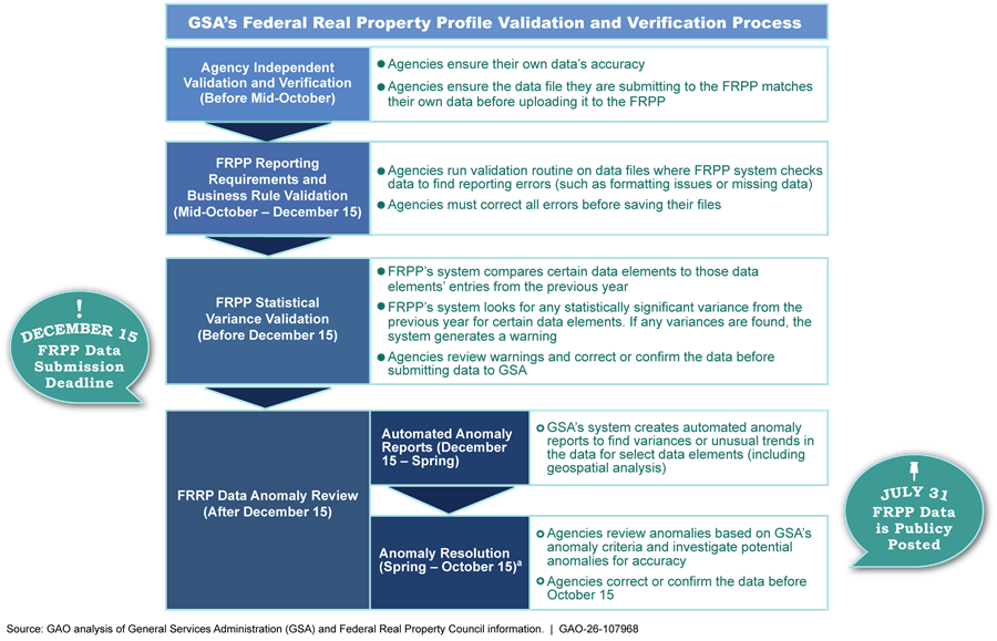
aThough GSA publishes the FRPP the July of the following year, agencies have until mid-October of the following year to complete the Anomaly Resolution step of the Validation and Verification process. GSA officials said that this October deadline was established to provide agencies with sufficient time to research and review the anomalies to determine whether the data reported is accurate or whether there are errors that will need to be corrected in the next year’s data submission.
After agencies submit their data to FRPP in December each year, GSA reviews the data and identifies questionable entries—called anomalies—in 10 separate categories. Through these 10 categories, GSA flags potential errors such as assets that: (1) have large changes from the prior year (such as a large increase in operating costs), (2) have unusual values for asset condition metrics, or (3) have an incorrect geospatial location.
When checking for geospatial anomalies as part of the Validation and Verification Process, GSA conducts an analysis to assess the accuracy of each asset’s reported latitude and longitude. In this analysis, GSA assesses whether assets are (1) located in the reported country, (2) located in the reported state, and (3) inappropriately identified as being located in a body of water.[26] Records outside the reported country or state or inappropriately located in a body of water are flagged as potential anomalies.
After completing the anomaly checks in the spring of each year, agencies use the FRPP management system to generate a list of potential anomalies. Agencies typically have 6 months to research each anomaly and identify whether they need to be corrected or validate that the data are correct.[27]
Additionally, agencies must submit a certification letter to GSA by January 31 of each year. Each agency’s letter must indicate that the agency followed the Validation and Verification process and characterizes the accuracy of the data the agency submitted to the FRPP.[28] While GSA has established the Validation and Verification Process to ensure the completeness and accuracy of the data agencies submit to the FRPP, GSA officials said that GSA must ultimately rely on agencies to submit quality data.
GSA Has Taken Steps to Improve FRPP Data Accuracy and Completeness, but Some Location Data Remain of Limited Accuracy
GSA Has Provided Agencies Guidance, Tools, and Processes to Improve FRPP Data Accuracy and Completeness
Since our 2020 report in which we identified errors with FRPP location data, GSA has taken steps to improve the accuracy and completeness of FRPP data by updating guidance and developing new guidance, tools, and processes.[29]
Guidance. GSA issues annual reporting guidance through its work with other entities. Specifically, each year, GSA coordinates with the FRPC to provide the Guidance for Real Property Inventory Reporting (also known as the data dictionary), which outlines how agencies should report real property data for the FRPP. The annual data dictionary describes data elements, reporting requirements, and how agencies can improve the quality of FRPP data. GSA officials told us that the data dictionaries are the primary source of guidance for the FRPP.
GSA and FRPC updated FRPP reporting requirements in the data dictionary as part of their efforts to address an open priority recommendation from our 2020 report regarding inaccurate street address data.[30] Beginning in fiscal year 2024, GSA and the FRPC changed their guidance to require that agencies submit latitude and longitude coordinates for all domestic federal buildings.[31] While agencies still have the option to submit buildings’ street addresses for those assets, they are no longer required to do so.[32]
GSA officials told us making latitude and longitude the primary means of identifying the location of domestic federal buildings resolved the street address data quality issues identified in our 2020 report. Officials said they made this change because latitude and longitude are easier to validate than street addresses. For example, street addresses can be entered into the database with incorrect formatting whereas GSA can define valid ranges for latitude and longitude data fields. Additionally, GSA officials said street addresses are problematic for assets that are not located on a street, such as those in national parks. We discuss the accuracy and completeness of FRPP latitude and longitude data below.
Also in response to our 2020 report, GSA worked with the FRPC to publish additional guidance prior to the fiscal year 2024 data submission.[33] This guidance organized FRPP data elements into three data quality tiers and directed agencies to initially focus on improving the data quality of Tier I data elements. The guidance describes Tier I data elements as being readily verifiable and largely static from year to year. It characterizes them as the most important data elements to improve data quality and support the FRPP’s inventory function and directs agencies to take all necessary actions to ensure these data elements are accurate and complete. Figure 2 includes descriptions of the three tiers with examples of the FRPP data elements each tier contains. FRPC incorporated these data quality tiers into its fiscal year 2025 data reporting guidance.
Figure 2: FRPC Federal Real Property Profile (FRPP) Data Quality Tiers and Examples of Data Elements
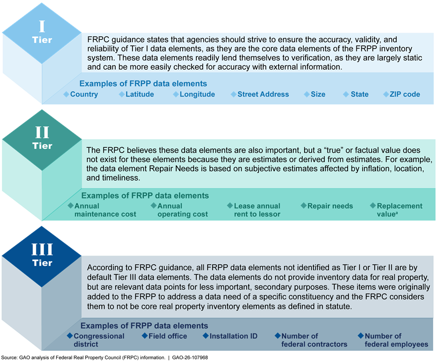
aReplacement value refers to the cost required to design, acquire, and construct an asset to replace an existing asset of the same functionality, size, and in the same location.
Tools. Since our 2020 report, GSA has developed two tools that officials said were intended to improve FRPP data quality: the benchmark validation tool and the geospatial validation tool.
· GSA officials said the benchmark validation tool shows agencies how selected FRPP data they submit compares to their prior year’s submission. Officials said this tool is meant to help agencies identify potentially unusual data before the agencies finalize their annual FRPP data submission in mid-December.
· GSA uses the geospatial validation tool to assess the validity and accuracy of building locations that are submitted by agencies reporting data for the FRPP. This tool can verify the combination of street address, city, state, and zip code and then assesses the quality of the address data (e.g., whether it is a full address or only a street name or zip code). If the tool finds an error in the address, agencies must correct the data before final submission for the FRPP. Prior to fiscal year 2024, agencies’ use of this tool was optional. In response to low use of the tool, GSA officials told us they automated this component of the tool for the fiscal year 2024 FRPP.[34]
Another component of the geospatial tool can report the distance between reported street address and latitude and longitude data associated with every office building over 5,000 square feet in the U.S. and U.S. territories. This component of the tool was not incorporated into the automated version of the tool in fiscal year 2024 but agencies have the option to use it if they submit street address data in addition to latitude and longitude.
Processes. In response to our 2020 report, FRPC initiated a third-party review process in 2024 to assess data quality that will occur every 3 years. GSA officials told us the third-party review process is intended to help agencies improve the accuracy of Tier I FRPP data in the agencies’ real property management systems to achieve a 90 percent confidence interval.[35] These officials told us that as part of this process, each agency’s selected third party—such as a contractor or an internal agency organization, e.g., the Chief Information Office—reviewed a sample of the agency’s data to assess whether that goal has been met. GSA officials stated such reviews had to be completed by March 2025. Agencies were required to include the results of the third-party review in their data quality improvement plans, which address how FRPP data elements are collected, verified, and validated prior to submission to GSA. The results of the third-party reviews must also be submitted to the FRPC.[36]
GSA officials said GSA and other FRPC members reviewed these plans and provided agencies with feedback, and that agencies who received a poor rating on their plan are working to edit the plans based on the feedback. Agencies must resubmit their plans by June 2026. GSA officials also told us they discussed the results of their reviews with agencies at the FRPC Data Governance Working Group in August 2025.[37] GSA officials said agencies will be required to submit data quality improvement plans again in 2028.
GSA officials told us GSA has also implemented other assessments of agency data. Specifically, these officials said GSA has collaborated with OMB and the FRPC to establish a real property scorecard to assess agency performance against a series of statutory and other policy requirements. GSA officials told us that, as a result of their efforts to work with agencies to improve location data, 99 percent of civilian agency assets had mappable location data in fiscal year 2024.[38] Officials said the percentage of all mappable location data (civilian and military) was 95 percent in both fiscal years 2023 and 2024.
In addition to these steps, GSA officials told us they had taken some action prior to our 2020 report to improve the completeness and accuracy of FRPP data each year through the agency’s Validation and Verification process, described above. Specifically, GSA checks for missing data in the Reporting Requirement Validation step when the FRPP computer system automatically reviews the uploaded data. GSA also checks for data accuracy during the Data Anomaly Review step where the system flags potential data errors, including any geospatial anomalies.
Selected FRPP Data Are Generally Complete
We tested the completeness of selected data elements and found selected data to be generally complete in fiscal year 2023 and fiscal year 2024.[39] To assess FRPP completeness, we tested 36 data elements for missing entries based on FRPP reporting requirements, similar to the tests that GSA runs in the Reporting Requirement Validation step of the Validation and Verification process.[40]
Almost all of the 36 data elements we tested were mostly complete in fiscal year 2023 and in fiscal year 2024.[41] In fiscal year 2023, 32 out of 36 data elements were over 95 percent complete, with 28 being 100 percent complete. These numbers slightly increased in fiscal year 2024, when 34 out of 36 data elements were over 95 percent complete, with 29 being 100 percent complete. Table 1 shows the selected data elements with less than 95 percent completeness in either fiscal year.
Table 1: Selected Federal Real Property Profile (FRPP) Data Elements Less Than 95 Percent Complete in Fiscal Years 2023 or 2024
|
Selected data element |
Percent complete in fiscal year 2023 |
Percent complete in fiscal year 2024 |
|
|
Estimated net present value as of todaya |
86.9 |
3.8 |
|
|
Main Locationb |
|||
|
|
Latitude |
80.9 |
99.2 |
|
|
Longitude |
80.9 |
99.2 |
|
|
Street address |
29.0 |
15.4 |
Source: GAO analysis of General Services Administration data. | GAO‑26‑107968
aGSA officials stated that the calculation of Estimated Net Present Value was not completed for fiscal year 2024 due to the scaling back of GSA contract resources in fiscal year 2025. Officials said as a result of these cuts, limited funding and staff were available to ensure the FRPP could be modified to comply with administration priorities. These officials said GSA will ensure that the Estimated Net Present Value is calculated each year moving forward.
bGSA officials told us main location data is required to be included in the FRPP. GSA has defined Main Location to include latitude, longitude, or street address (depending on the fiscal year of the submission and whether there are specific concerns with reporting exact coordinates). For example, prior to fiscal year 2024, latitude and longitude were the preferred location data for assets. During this time, agencies could submit street addresses in place of longitude and latitude if the coordinates were unknown or for security reasons. Agencies could also submit both street address and latitude and longitude for each building. Beginning in fiscal year 2024, FRPP guidance required that agencies submit latitude and longitude data and made street address data submission optional for domestic building assets.
Our analysis of domestic buildings found that the completeness of latitude and longitude data increased after GSA and FRPC issued guidance requiring these elements for all domestic building assets. At the same time, street address data completeness decreased after it became optional for these buildings.[42]
FRPP Building Location Data Are Accurate at the Country and State Level, But Are Less Accurate at a Granular Level
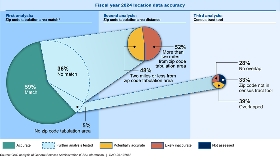
We found FRPP domestic location data for fiscal year 2024 to be generally accurate at the state and country level (which is the level of granularity assessed by GSA) but less accurate at a more granular level.[43] Specifically, in fiscal year 2024, of domestic latitude and longitude coordinates, (1) more than 99 percent were located in the reported country, (2) more than 99 percent were located in the reported state, and (3) less than 1 percent were inappropriately located in a body of water.[44] However, since location data at the state level would not provide insight into the actual location of a building and our prior work found inaccuracies in location data at a more granular level, we then tested the reported latitude and longitude coordinates of domestic federal buildings against the reported zip codes through a series of analyses. We divided the data into four groups: (1) accurate data, (2) potentially accurate data, (3) likely inaccurate data, and (4) data we were unable to assess.[45] About 78 percent of domestic building latitude and longitude data in fiscal year 2024 were accurate or potentially accurate when analyzed at the zip code level and about 20 percent were likely inaccurate (see fig. 3).[46]
Figure 3: Accuracy of Federal Real Property Profile Domestic Latitude and Longitude Data at the Zip Code Level
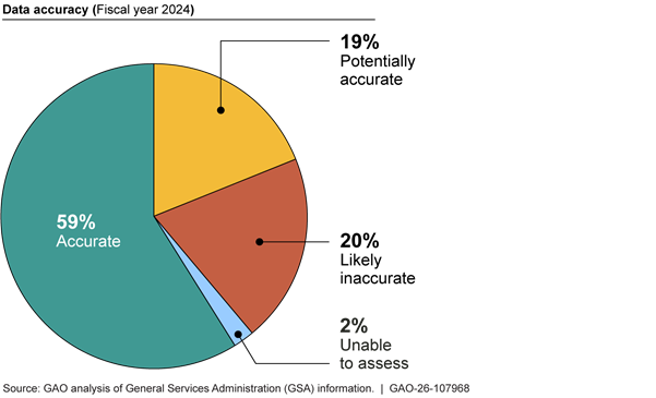
· Around 59 percent of all location data are accurate. We defined location data as accurate if a building’s latitude and longitude coordinates matched the corresponding zip code reported in the FRPP.[47]
· Around 19 percent of all location data are potentially accurate data. Since zip code tabulation areas may not be exact and do not exist for every zip code reported in the FRPP, we defined potentially accurate data to include buildings whose coordinates were close to the zip code reported in the FRPP.[48]
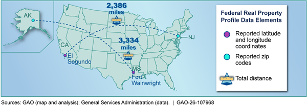
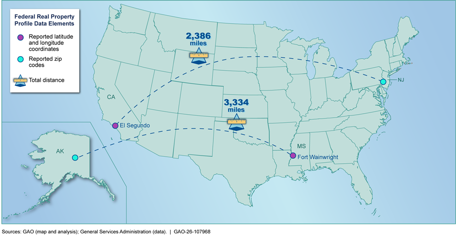
· Around 20 percent of all location data are likely inaccurate data. We defined likely inaccurate data to include buildings whose coordinates were far from the zip code reported in the FRPP.[49] Cases that fell into this category may have had inaccurate latitude and longitude coordinates, an inaccurate zip code, or both. Some of the buildings in the “likely inaccurate” category had coordinates that were significantly far from the zip code tabulation area they were supposed to be in. For example, of the records that were outside of the corresponding zip code tabulation area, more than 8 percent were over 20 miles from the expected zip code tabulation area in fiscal year 2024. The five furthest records were buildings that all had coordinates locating them over 2,200 miles from their reported zip code (see fig. 4 for two examples).
Figure 4: Examples of Significant Mismatches between Federal Real Property Profile’s Latitude and Longitude Data and Zip Code Data
· About 2 percent of location data could not be assessed. We could not assess the accuracy of latitude and longitude data if the zip code reported in the FRPP did not have a corresponding zip code tabulation area and was not included in the census look up tool.[50]
GSA officials told us that ultimately FRPP data quality relies on the quality of the data submitted by agencies since the FRPP data is a compilation of agency-submitted data. Further, officials said they have no way to incentivize agencies to report high quality data or penalize agencies for reporting poor quality data.
GSA has implemented processes and tools intended to improve FRPP location accuracy, but these efforts are not fully ensuring the data agencies report meets the accuracy standards GSA and the FRPC set for Tier I data, which includes location data. As noted above, GSA has instructed agencies to take all necessary steps to ensure the accuracy of Tier I data in reporting guidance and set a goal for a 90 percent confidence interval when testing a sample of agency Tier I data. However, the accuracy of fiscal year 2024 location data, which is Tier I data, does not meet this goal.[51]
Additionally, GSA’s Validation and Verification Process only assesses location accuracy at a high level—through country, state, and body of water tests—limiting GSA’s ability to identify FRPP data inaccuracies at a more granular level. For example, if an agency incorrectly reported latitude and longitude coordinates in Houston, TX, for a building located in El Paso, TX, GSA’s Validation and Verification process would not identify this as an anomaly since the two cities are in the same state but around 670 miles apart. GSA officials told us the geospatial validation tool can assess the distance between a given building’s reported latitude and longitude and its reported street address. However, this specific use of the tool has not been automated and street addresses, which are necessary for this tool, were only reported for about 15 percent of cases in fiscal year 2024, as this data element is now optional. This could complicate efforts to assess any disparities between street address and latitude and longitude.
Further, the inaccuracies we found in FRPP data affect its intended use as a comprehensive database of all federal real property. We found that approximately one in five location records in fiscal year 2024—the latest data available as of the time of this report—may be inaccurate, and through our interviews, stakeholders told us they do not have confidence in the accuracy of this data. Eight of nine real property industry stakeholders told us that concerns about the reliability of FRPP data limit the usefulness of the database, as discussed further below.[52] In addition, without the requirement for street addresses, accuracy of latitude and longitude data is even more critical, but time-consuming and difficult to assess.
Standards for Internal Control in the Federal Government state that management should design control activities to support the accuracy of information and achieve an entity’s objectives.[53] GSA’s current Validation and Verification process and tools only support the accuracy of location information at a high level, limiting the FRPP’s ability to serve its intended purpose as an inventory database with complete information from all agencies. Unless GSA works with the FRPC and OMB to improve the accuracy of location data submitted by federal agencies, the FRPP will likely continue to have significant inaccuracies and be of limited usefulness.
Selected Agencies and Stakeholders Make Limited Use of the FRPP and GSA Has Not Identified How to Improve Its Usefulness
Officials from all five selected agencies and all nine federal real property stakeholders we interviewed told us they make limited use of the FRPP. Officials from the selected agencies said they relied on their agencies’ own real property management systems instead, and real property industry stakeholders cited concerns with the FRPP including its data reliability, presentation, and timeliness.[54] GSA officials said they have not determined which of the FRPP’s data elements are most useful to agencies and stakeholders or whether streamlining some data elements could make the FRPP more useful and cost effective.
All Five Selected Agencies Make Limited Use of the FRPP and Rely on Their Own More Comprehensive Systems
Officials from four of the five selected agencies told us they make limited use of FRPP data in certain cases. For example, officials from DOE, Interior, and USDA said they use the data for illustrative purposes, such as to inform agency leadership, or to make broad comparisons with other agencies. Additionally, Army officials said they had used FRPP data to assess progress toward environmental sustainability metrics.
In addition, some federal agencies use the FRPP to respond to questions from Congress. GSA officials told us the FRPP is primarily useful for illustrative purposes. These officials said Congress and the public can use the FRPP to obtain information on the federal real property footprint. Officials from GSA and the Congressional Research Service told us they use FRPP data to respond to congressional queries, such as how many federal buildings are located within a certain congressional district. We have made similar use of these data in response to congressional inquiries.
Officials from each of the five selected agencies told us they did not use the FRPP to manage their real property portfolios.[55] GSA officials also acknowledged that the FRPP is intended as an annual inventory and is generally not suitable for real property management. Officials from the five selected agencies said they used their own more comprehensive real property management systems—computer systems containing data to inform real property management decisions—to track and manage their real property information instead. For example, USDA officials said they do not use the FRPP because it is a static inventory depicting a snapshot at a given moment in time, making it unsuitable for real property management or portfolio decisions. These officials said USDA’s real property system is continuously updated and contains many data elements in addition to those needed for the FRPP. Similarly, Interior officials told us the system they use to manage their real property portfolio contains more detailed information than the data they submit to GSA for the FRPP. For example, officials said Interior’s system tracks maintenance costs and contains more detailed descriptions of buildings than the FRPP.
GSA officials said they developed tools based on FRPP data to assist agencies in asset consolidation, colocation, and disposals, but officials from four of the five selected agencies said they make limited use of these tools.[56] For example, DOE officials said GSA’s tools are of limited utility because they are based on data that is already out of date by the time the FRPP tools are made available. These officials said they instead rely on interagency councils like the FRPC to identify federal property owners in a given area, or on their own ad hoc tools to answer questions from Congress. While officials from four of the selected agencies said they make limited use of GSA’s FRPP tools, Interior officials said they use GSA’s FRPP geospatial validation tool to find real property assets that had been identified as being in the wrong location.
All Nine Selected Stakeholders Said the FRPP is of Limited Usefulness Due to Concerns Including Data Reliability and Timeliness
All nine selected federal real property stakeholders told us the FRPP has limited usefulness. While five stakeholders identified potential uses for the data, such as understanding federal leasing in a specific market or identifying locations for wireless infrastructure, they noted limitations and, in some cases, identified other data sources they rely on instead. Stakeholders identified several concerns about using FRPP data, including:
· Reliability. Eight of the nine selected stakeholders expressed concerns about the reliability of FRPP data. For example, a private sector stakeholder told us the FRPP’s building location data is unreliable. Similarly, representatives from another private sector stakeholder said data in the FRPP’s net present value data element—a financial metric—was unreliable. These representatives said it was not clear how the FRPP’s net present value data had been developed. In addition, Public Building Reform Board officials and representatives of a commercial real estate and investment firm that contracted with the Board told us they had difficulty using the FRPP in attempting to dispose of federal real property.[57] Specifically, they said they faced challenges related to the reliability of street address data and said it was difficult to locate a building using latitude and longitude coordinates without also having a reliable street address.
· Timeliness. Five of the nine selected stakeholders said the FRPP’s usefulness is limited because its data is not timely. For example, one stakeholder said some data elements may not have been reliably updated on an annual basis, based on their experience. Further, two other stakeholders said the FRPP is not as useful as other real property databases because it is only updated once a year.
· Presentation. Six of the nine selected stakeholders expressed concerns with GSA’s presentation of FRPP data. These stakeholders said the data is difficult to use due to formatting, file size, and the absence of filters to organize the data. Two stakeholders said that FRPP files are so large they often cause computers to crash. GSA’s public FRPP spreadsheet for fiscal year 2024 civilian real property data is about 138 megabytes in size, with information on more than 283,000 properties spread across up to 117 columns.[58] One stakeholder suggested that an option to filter the information to download only the data needed by a given user could result in a more manageable file size and increased usefulness. Some stakeholders also said the tools GSA has developed based on FRPP data are presented in ways that limit their utility. For example, two stakeholders said a GSA mapping tool using FRPP data was confusing and difficult to use. In addition, stakeholders differed regarding whether street address or latitude and longitude is the most useful way to present location data. One stakeholder said latitude and longitude are not useful and they prefer to use street address. In contrast, another stakeholder said latitude and longitude were more reliable when mapping locations. A third agreed that the coordinates were helpful when using mapping software but added that without using such software it is difficult to locate a building with an unknown street address.
In addition, some stakeholders told us an annual inventory may not be the appropriate tool for certain information that is only useful if updated more frequently than annually. For example, one federal real property stakeholder told us that because leasing information is subject to frequent changes, the FRPP is a poor resource for such information. GSA officials told us that due to the time needed to report and process agencies’ data for the FRPP, the data is accurate as of 6 to 18 months before the FRPP’s public version is made available, at best. Most stakeholders said they preferred to use other resources that are more accurate or more frequently updated than the FRPP. For example, seven stakeholders said they preferred to use other sources of real property data, such as GSA’s Inventory of Owned and Leased Properties database, because they are more reliable, easier to use, and more frequently updated.[59]
GSA Has Not Identified the Usefulness of FRPP Data Elements or Ways to Streamline or Improve the Data
GSA officials said they have not identified which data elements are most useful to agencies and stakeholders or how best to present FRPP data. These officials told us they generally add or remove data elements in response to requirements from Congress or the administration. Specifically, officials said FASTA increased the total number of FRPP data elements. GSA officials speaking on behalf of the FRPC told us the FRPC is conservative about making changes to FRPP, as it can take years for agencies to implement changes to their own systems, and in some cases, agencies may be resistant to changes, including the removal of data elements. As previously noted, the FRPP contains over 100 data elements and subcomponents for each building, although which elements are required may vary based on factors such as whether the building is owned or leased. GSA identified 33 of these data elements as required by statute.[60] Any data elements required by statute cannot be removed without congressional action.
GSA officials told us that GSA and the FRPC developed FRPP’s new data quality tiers primarily based on which data elements were static and more easily verifiable. They said the tiers can be helpful in prioritizing agency efforts to improve the accuracy of certain data elements but do not reflect the relative utility of the data elements for agencies and stakeholders.
In addition, GSA officials told us the FRPP has always been intended as an annual inventory and not a real property management system, which officials said is frequently misunderstood. Officials added that developing a government-wide real property management system would require changes to statutes and millions of dollars in new funding. Moreover, these officials told us GSA does not have the authority to develop such a system, and that requiring agencies to report data in a new system would be burdensome. Specifically, agencies’ existing real property management systems are integrated with other agency systems, such as those used for financial management, maintenance needs, and capital planning. Additionally, agencies may collect data in ways that differ from the data reported in the FRPP.[61]
OMB guidance notes the need for agencies to identify core audiences for their online resources and conduct user research to identify the specific needs of those audiences.[62] Additionally, Standards for Internal Control in the Federal Government state that agencies should select appropriate methods for communicating information based on factors such as the purpose of the information, cost, and legal or regulatory requirements. These standards also note that agencies should use a forward-looking process and planning efforts to respond to change (such as changes in user needs related to the FRPP). Such planning efforts can include assessing needed resources and communicating with external parties (such as agencies that report data to the FRPP) that may contribute to the effectiveness of the agency’s efforts. Because GSA relies on agencies to submit information for the FRPP and some elements are statutorily required, GSA would need input from agencies, real property industry stakeholders, Congress, and the FRPC to understand user needs and whether any changes are needed to improve the collection, presentation, and timeliness of FRPP data.
While GSA officials told us it annually costs their agency around $300,000 to develop and maintain the FRPP, the government-wide nature of annual FRPP reporting makes it difficult to identify the total federal resources required across all agencies. GSA relies on Congress and the administration for direction regarding when to add or remove data elements. However, it has not developed a plan to assess FRPP user needs to determine if the current FRPP data elements still meet user needs, and whether there are opportunities to save costs and resources by streamlining data collection to focus on the most important elements. Additionally, because GSA does not know what FRPP data is most useful to agencies and stakeholders, it does not know how to present the data in the most useful way (for example, whether removing the requirement for street addresses negatively affected users, or whether a more streamlined presentation of the FRPP data would be more useful). As a result, GSA may be missing opportunities to provide a FRPP product that could better support efforts to use federal space in a more efficient and effective manner.
Conclusions
The FRPP, as an inventory of the federal government’s real property assets, could be an important tool to help inform ongoing efforts to more efficiently use that space. GSA has taken steps to improve the database’s accuracy and completeness in recent years and has made some progress. However, there are still problems with the accuracy of the FRPP’s building location data. Without additional actions by GSA, in coordination with OMB, FRPC, and reporting agencies, that data will likely continue to have significant inaccuracies and be less useful than it could be in helping to identify and dispose of unneeded federal real property.
Moreover, agency officials and stakeholders we interviewed told us they generally do not use the FRPP and that it is of limited utility. Stakeholders noted concerns with the reliability, timeliness, and presentation of the data, and varied in their opinion of the usefulness of geocoordinates versus street addresses. At the same time, the FRPP may contain over 100 data elements per building, and agencies must expend resources to update data fields that are of unclear value. Developing and implementing a plan to streamline the FRPP could help GSA improve the collection, presentation, and timeliness of its data and focus agency efforts on ensuring the reliability of a smaller number of core data elements. Further, incorporating input from Congress, the FRPC, and real property industry stakeholders would allow GSA to identify and improve those data elements that are most useful to FRPP’s target audience and better ensure agency resources are employed to develop a more useful, cost-effective product.
Recommendations
We are making the following three recommendations to GSA:
The GSA Administrator, in coordination with the Director of the OMB, the FRPC, and reporting agencies, should improve the accuracy of building location data in the FRPP. For example, GSA could revise its Validation and Verification process or tools to ensure that different location data points such as geocoordinates and zip codes are in alignment. (Recommendation 1)
The GSA Administrator should develop a plan that outlines the steps, resources, and any legislative changes needed to streamline and improve the FRPP as well as a proposal for any legislative changes needed. The plan should be based on user needs and include input on the data elements’ usefulness from Congress, the FRPC, and other real property industry stakeholders. For example, GSA could solicit input on the usefulness of geocoordinates and street addresses. (Recommendation 2)
The GSA Administrator should implement this plan and communicate any changes to Congress, the FRPC, and real property industry stakeholders. As part of its communication, the agency should consult with Congress about any legislative changes needed to streamline and improve the FRPP. (Recommendation 3)
Agency Comments
We provided a draft of this report to GSA for review and comment. In its written comments, reproduced in appendix III, GSA concurred with the recommendations. GSA highlighted some of its previous efforts to improve FRPP data and stated it will work to address our recommendations.
We are sending copies of this report to the appropriate congressional committees, the Administrator of the General Services Administration, and other interested parties. In addition, the report is available at no charge on the GAO website at https://www.gao.gov.
If you or your staff have any questions about this report, please contact me at marronid@gao.gov. Contact points for our Offices of Congressional Relations and Media Relations may be found on the last page of this report. GAO staff who made key contributions to this report are listed in appendix IV.
Sincerely,

David Marroni
Director, Physical Infrastructure
In this report, we examined: (1) the steps the General Services Administration (GSA) has taken to improve Federal Real Property Profile (FRPP) data quality and the extent to which selected data elements for buildings are accurate and complete, and (2) the extent to which selected agencies and stakeholders use FRPP data. We focused our report on domestic building properties, including civilian and military properties.[63]
For both objectives, we reviewed documentation, such as guidance and user guides, from GSA and the Federal Real Property Council (FRPC) and previous GAO reports.[64] Additionally, we interviewed GSA officials to gather information on GSA’s efforts to ensure FRPP data accuracy and completeness, identify issues that may affect the accuracy and completeness of FRPP data, and track FRPP usage. GSA also provided us with a demonstration of its validation and verification tools.
Additionally, we interviewed a non-generalizable selection of five agencies that report data to GSA for the FRPP. To select these agencies, we identified agencies with the greatest total count of domestic buildings as reported in the FRPP. To ensure a mixture of civilian and military federal buildings, we selected the top two Department of Defense (DOD) agencies and top three civilian agencies (other than GSA). The agencies with the highest number of buildings were the Department of the Army, Department of the Navy, Department of the Interior, Department of Agriculture, and Department of Energy. Speaking with these entities allowed us to better understand the FRPP data reporting process, issues that may affect data quality, agencies’ use of the FRPP, and barriers to agencies’ use.
For our first objective, we analyzed the completeness of selected data elements—specifically, data elements related to building location and elements that GSA identified as required by statute to appear in the FRPP. We also reviewed relevant statutes and executive orders. Based on this review, we compiled an initial list of data elements in the FRPP that were required by statute in fiscal years 2023 and 2024. We asked GSA to review and confirm or correct this list of data elements. We used the list of 33 data elements that GSA identified as required by statute as the basis for our completeness analysis.
To understand how agencies are required to submit data for these elements, we examined the guidance that GSA and FRPC provide to agencies, including FRPP data dictionaries. The list of 33 data elements GSA identified as required by statute, as well as their associated reporting requirements, are shown in table 2. Not all elements GSA identified as statutorily required are elements that agencies are required to report. Some elements are calculated based on other elements and other elements have optional reporting directives.
Table 2: Reporting Requirements for Statutorily Required Federal Real Property Profile Data Elements for Domestic Buildings in Fiscal Years 2023 and 2024 as Identified by GSA
|
Data elements |
Reporting requirements |
|
Building age |
Calculated based on Year of Asset Construction, only required for non-disposed assets with a legal interest of Owned or Museum Trust |
|
Can the number of contractors be determined |
Required for all non-disposed building assets |
|
Can the number of federal employees be determined |
Required for all non-disposed building assets |
|
Cannot currently be disposed date |
Required for assets with Status Indicator of Cannot Currently be Disposed |
|
Condition index |
Calculated based on repair needs and replacement value, not required for assets with a legal interest of leased, only required for assets with a legal interest of (1) owned and otherwise managed with (2) a status indicator of Current Mission Need and Future Mission need. |
|
Estimated future capital expenditures |
Required for all non-disposed owned assets |
|
Estimated net present value |
Calculated for leased non-disposed properties |
|
Federal contractors |
Required for all building assets where “Can the Number of Federal Contractors Be Determined” equals YES |
|
Federal employees |
Required for all building assets where “Can the Number of Federal Employees Be Determined” equals YES |
|
Field office (flag if not HQ) |
Required for all non-disposed office buildings |
|
Field office collocation |
Required for non-disposed office buildings where the field office data element is reported as Field Office |
|
Historical capital expenditures |
Required for all non-disposed owned building assets |
|
Is asset excluded (y/n flag) |
Required for all non-disposed assets |
|
Lease expiration date |
Required for all non-disposed leased assets |
|
Lease start date |
Required for all non-disposed leased assets |
|
Lease annual rent to lessor |
Required for all leased assets |
|
Leased annual maintenance costs |
Required for all leased assets |
|
Leased annual operations costs |
Required for all leased assets |
|
Main locationa |
|
|
Latitude |
Fiscal year 2023: May submit Street Address, Latitude and Longitude, or both Fiscal year 2024: Required for all building assets in U.S. and U.S. Territories |
|
Longitude |
Fiscal year 2023: May submit Street Address, Latitude and Longitude, or both Fiscal year 2024: Required for all building assets in U.S. and U.S. Territories |
|
Street address |
Fiscal year 2023: May submit if Latitude and Longitude are unknown or if not allowed for security reasons. Fiscal year 2024: May submit in addition to Latitude and Longitude. |
|
Reason for exclusion |
Required for all assets where “FASTA Disposal Exclusion” equal YES |
|
Report of excess submitted date |
Required for assets with status indicator of Report of Excess Submitted |
|
Reporting agency |
Required for all assets |
|
Reporting bureau |
Required for all assets |
|
State name |
Required for all assets located in the U.S. It is not to be reported for assets located where the country is not the United States, nor in the U.S. Territories. |
|
Surplus declaration date |
Required for all assets with status indicator of Surplus |
|
Sustainability |
Required for all non-disposed building assets greater than or equal to 25,000 gross square feet, located in United States and U.S. territories with a Legal Interest of Owned or Museum Trust. |
|
Using agency |
Required for all non-disposed building assets |
|
Using bureau |
Required for all non-disposed building assets |
|
Utilization |
Required for all non-disposed buildings with the following predominant use categories: offices, hospitals, family housing, dormitories and barracks, warehouses, and laboratories |
|
Year asset reported underutilized |
Required if “Utilization” is Unutilized or Underutilized and is required for the following building predominant use categories: offices, hospitals, family housing, dormitories and barracks, warehouses, and laboratories. |
|
Year of construction |
Required for all non-disposed assets with Legal Interest of Owned or Museum Trust |
Source: GAO presentation of Federal Real Property Council information. | GAO-26-107968
aGSA officials told us main location data is statutorily required to be included in the FRPP. Depending on the fiscal year agencies could meet this requirement by reporting latitude and longitude coordinates, a street address, or both. Under fiscal year 2025 FRPP reporting guidance, agencies must submit latitude and longitude data for all domestic building assets to fulfill the main location requirement.
We tested the completeness of the FRPP data elements that GSA identified as statutorily required, as well as three other elements related to building location (city, country, and zip code).[65] To do so, we assessed the extent to which data had been inappropriately reported as null (i.e., has no data) based on those elements’ reporting requirements. For example, the data element Leased Annual Maintenance Costs is only required for leased properties so for this data element we only tested leased properties for completeness.
Additionally, we assessed the accuracy of selected FRPP location data elements for domestic buildings reported in the fiscal year 2024 FRPP.[66] Since the street address data element was made optional in fiscal year 2024, we were unable to further test the accuracy of street address data and compare it to the results of our 2020 report.[67] Instead, we focused this review on the accuracy of fiscal year 2024 latitude and longitude data as GSA made reporting mandatory for this element in fiscal year 2024.[68] To do so, we duplicated GSA’s tests of latitude and longitude to ensure the buildings are identified as being (1) in the correct country, (2) in the correct state, and (3) not inappropriately in a body of water. To test country location and whether a building was in a body of water, we used Esri’s ArcGIS Living Atlas World Countries Layer with a 1,000 foot layer for water.[69] For every building that had a latitude and longitude, we determined whether it was in the U.S. (or its territories), in another country, in water, or none of the above.[70] To test reported longitude and latitude against reported U.S. states, we used the United States State Boundaries layer from the U.S. Census. For every building that we determined to be in the U.S. in our previous analysis, we determined whether it matched the reported state or did not match the reported state.
To assess the accuracy of latitude and longitude at a more granular level, we compared reported latitude and longitude coordinates to reported zip codes. We used a combination of three analyses to test the correspondence between reported zip codes and latitude and longitude coordinates. These analyses were based on zip code tabulation areas and a tool linking zip codes to census tracts.[71] Mismatches between latitude and longitude coordinates and zip codes or census tracts indicated that at least one location element may be inaccurate. We found evidence of cases where the zip code was accurate, but the latitude and longitude coordinates were inaccurate, and vice versa.
· Zip code tabulation area match analysis. Our first analysis determined whether latitude and longitude coordinates fell within the zip code tabulation area corresponding to the zip code reported in the FRPP. Zip code tabulation areas were developed by the US Census to enable the mapping and analyses of zip codes by creating geographic representations of zip codes based on 2020 Census tabulation blocks. This analysis allowed us to locate latitude and longitude within individual zip code tabulation areas. However, this analysis has two limitations. Zip code tabulation areas do not exist for all zip codes, meaning that there are latitude and longitude coordinates in the FRPP that do not fall into any zip code tabulation area. Additionally, zip code tabulation areas are not precise representations of zip codes, so there could be errors when comparing actual zip codes with zip code tabulation areas. For this analysis, we tested all buildings with latitude and longitude coordinates that were located in the United States to assess whether the latitude and longitude coordinates fell within the appropriate zip code tabulation area (match), fell outside the zip code tabulation area (no match), or did not have a corresponding zip code tabulation area (no zip code tabulation area). If the latitude and longitude coordinates matched the zip code tabulation area, we considered that data to be accurate. We then further tested the rest of the latitude and longitude data to address the limitations of this analysis, as described below.
· Zip code tabulation area distance analysis. Our second analysis tested the distance between the location of a building’s latitude and longitude coordinates and its relevant zip code tabulation area. For this analysis, we only tested latitude and longitude coordinates that fell outside of the zip code tabulation area (no match) in the previous analysis. Because the zip code tabulation areas are not precise representations of zip codes, we considered latitude and longitude coordinates that were 2 miles or less from the zip code tabulation area to be potentially accurate data. We considered latitude and longitude coordinates that were more than 2 miles from the zip code tabulation area to be likely inaccurate data.
· Census tract analysis. Our third analysis used census tracts to further test latitude and longitude coordinates for buildings with a zip code that did not have a corresponding zip code tabulation area. The Department of Housing and Urban Development (HUD) has developed a file linking zip codes to census tracts.[72] This file identifies the ratios of address type in the geography the zip code overlaps. To conduct this analysis, we identified the census tract containing a given building’s reported latitude and longitude coordinates. We then used the HUD file to determine whether that census tract overlaps with the zip code reported in the FRPP. If the census tract containing the building’s coordinates overlapped the reported zip code to any extent, we considered the latitude and longitude data to be potentially accurate. However, if the census tract containing the coordinates had no overlap with the reported zip code, we considered the latitude and longitude data to be likely inaccurate data. This analysis had one limitation: not every zip code reported in the FRPP was present in the HUD census tract tool. Due to this limitation, we were unable to access the accuracy of around 2 percent of FRPP records in fiscal year 2024.
We compared GSA’s efforts to provide FRPP data against Office of Management and Budget (OMB) guidance and Standards for Internal Control in the Federal Government related to information. Figure 5 demonstrates our analysis of location data.
aThis analysis tested all fiscal year 2024 Federal Real Property Profile domestic building records that had latitude and longitude values.
For the second objective, in addition to interviewing the agency officials described above, we interviewed a non-generalizable selection of nine federal real property industry stakeholders, including representatives from investment management companies, a law firm, industry associations, and a federal agency with the mission to identify and recommend federal properties for sale. We asked all stakeholders a series of questions regarding stakeholders’ familiarity and use of the FRPP and analyzed the results across all nine interviews to develop summary statements for the report. We selected these entities based on our prior work, our own research, and stakeholder recommendations. We spoke with representatives from Colliers, CTIA, FD Stonewater, Holland and Knight, Jones Lang Lasalle, the National Federal Development Association, and the Public Buildings Reform Board, as well as two individual federal real property stakeholders.[73] This allowed us to gather information on how stakeholders use FRPP and barriers they cited to its use. We compared GSA’s efforts to provide FRPP data against OMB guidance and Standards for Internal Control in the Federal Government related to information, communication, and responding to change.[74]
We conducted this performance audit from December 2024 to June 2026 in accordance with generally accepted government auditing standards. Those standards require that we plan and perform the audit to obtain sufficient, appropriate evidence to provide a reasonable basis for our findings and conclusions based on our audit objectives. We believe that the evidence obtained provides a reasonable basis for our findings and conclusions based on our audit objectives.
As part of this review, we conducted several types of analysis of the Federal Real Property Profile (FRPP) data from fiscal year 2023 and fiscal year 2024. Our analysis tested the completeness and accuracy of selected FRPP data on domestic buildings, including civilian and Department of Defense (DOD) properties. As discussed in our report, our analysis showed selected fiscal year 2023 and fiscal year 2024 data to be generally complete and the fiscal year 2024 location data to be accurate at the country and state level but partially inaccurate at a more granular level. Below, we discuss these results in detail.
Completeness Results
Almost all of the 36 data elements we tested were mostly complete in both fiscal year 2023 and fiscal year 2024 (see table 3).[75]
Table 3: Completeness of Selected Federal Real Property Profile Data Elements for Domestic Buildings in Fiscal Year 2023 and 2024
|
Selected data element |
Percent complete in fiscal year 2023 |
Percent complete in fiscal year 2024 |
|
Building age |
100 |
100 |
|
Can the number of federal contractors be determined |
100 |
100 |
|
Can the number of federal employees be determined |
100 |
100 |
|
Cannot currently be disposed |
100 |
100 |
|
City name |
100 |
100 |
|
Country name |
100 |
100 |
|
Estimated future capital expenditures |
100 |
100 |
|
Federal contractors |
100 |
100 |
|
Federal employees |
100 |
100 |
|
Field office |
100 |
100 |
|
Field office collocation |
100 |
100 |
|
Historical capital expenditure |
100 |
100 |
|
Is asset excluded |
100 |
100 |
|
Lease annual rent to lessor |
100 |
100 |
|
Lease expiration date |
100 |
100 |
|
Lease start date |
100 |
100 |
|
Leased annual maintenance cost |
100 |
100 |
|
Leased annual operations cost |
100 |
100 |
|
Reason for exclusion |
100 |
100 |
|
Report of excess submitted date |
100 |
100 |
|
Reporting agency |
100 |
100 |
|
Reporting bureau |
100 |
100 |
|
Surplus declaration date |
100 |
100 |
|
Using agency |
100 |
100 |
|
Using bureau |
100 |
100 |
|
Zip code |
100 |
100 |
|
Year asset reported underutilized |
100 |
100 |
|
Year of construction |
100 |
100 |
|
Utilization |
99.99 |
99.99 |
|
Condition index |
99.98 |
100 |
|
Sustainability |
98.87 |
99.04 |
|
State name |
98.16 |
98.14 |
|
Estimated net present value as of todaya |
86.87 |
3.84 |
|
Main locationb |
||
|
Latitude |
80.88 |
99.19 |
|
Longitude |
80.88 |
99.19 |
|
Street address |
29.03 |
15.41 |
Source: GAO analysis of General Services Administration data. | GAO‑26‑107968
aGSA officials stated that the calculation of Estimated Net Present Value was not completed for fiscal year 2024 due to the scaling back of GSA contract resources in fiscal year 2025. Officials said as a result of these cuts, limited funding and staff were available to ensure the FRPP could be modified to comply with administration priorities. These officials said GSA will ensure that the Estimated Net Present Value is calculated each year moving forward.
bGSA officials told us main location data is required to be included in the FRPP, and GSA has defined Main Location to include latitude, longitude, or street address (depending on the fiscal year of the submission and whether there are specific concerns with reporting exact coordinates). For example, prior to fiscal year 2024, latitude and longitude were the preferred location data for assets. During this time, agencies could submit street addresses in place of longitude and latitude if the coordinates were unknown or for security reasons. Agencies could also submit both street address and latitude and longitude for each building. Beginning in fiscal year 2024, FRPP guidance required that agencies submit latitude and longitude data and made street address data submission optional for domestic building assets.
Civilian and DOD agencies generally reported selected data elements at similar levels (see table 4). One example of different reporting levels was the street address data element, which DOD agencies significantly reduced reporting in fiscal year 2024 after it was made optional.
Table 4: Completeness of Selected Federal Real Property Profile Data Elements in Fiscal Year (FY) 2023 and 2024 by Agency Type
|
Selected data element |
Percent complete |
Percent complete in FY 2023 by DOD agencies |
Percent complete |
Percent complete in FY 2024 by DOD agencies |
|
Building age |
100 |
100 |
100 |
100 |
|
Can the number of federal contractors be determined |
100 |
100 |
100 |
100 |
|
Can the number of federal employees be determined |
100 |
100 |
100 |
100 |
|
Cannot currently be disposed |
100 |
- |
100 |
100 |
|
City name |
100 |
100 |
100 |
100 |
|
Country name |
100 |
100 |
100 |
100 |
|
Estimated future capital expenditures |
100 |
100 |
100 |
100 |
|
Federal contractors |
100 |
- |
100 |
- |
|
Federal employees |
100 |
- |
100 |
- |
|
Field office |
100 |
100 |
100 |
100 |
|
Field office collocation |
100 |
100 |
100 |
100 |
|
Historical capital expenditure |
100 |
100 |
100 |
100 |
|
Is asset excluded |
100 |
100 |
100 |
100 |
|
Lease annual rent to lessor |
100 |
100 |
100 |
100 |
|
Lease expiration date |
100 |
100 |
100 |
100 |
|
Lease start date |
100 |
100 |
100 |
100 |
|
Lease annual maintenance cost |
100 |
100 |
100 |
100 |
|
Lease annual operations cost |
100 |
100 |
100 |
100 |
|
Reason for Exclusion |
100 |
100 |
100 |
100 |
|
Report of excess submitted date |
100 |
- |
100 |
100 |
|
Reporting agency |
100 |
100 |
100 |
100 |
|
Reporting bureau |
100 |
100 |
100 |
100 |
|
Surplus declaration date |
100 |
100 |
100 |
100 |
|
Using agency |
100 |
100 |
100 |
100 |
|
Using bureau |
100 |
100 |
100 |
100 |
|
Year asset reported underutilized |
100 |
100 |
100 |
100 |
|
Zip code |
100 |
100 |
100 |
100 |
|
Condition index |
99.96 |
100 |
100 |
100 |
|
State name |
99.08 |
97.39 |
99.06 |
97.37 |
|
Year of construction |
100 |
100 |
100 |
100 |
|
Utilization |
99.97 |
100 |
99.99 |
100 |
|
Estimated net present value |
96.97 |
58.57 |
5.21 |
100 |
|
Sustainability |
96.80 |
99.71 |
97.54 |
99.65 |
|
Main locationa |
||||
|
Latitude |
82.94 |
79.16 |
98.22 |
100 |
|
Longitude |
82.94 |
79.16 |
98.22 |
100 |
|
Street address |
38.88 |
20.84 |
33.83 |
0.09 |
Source: GAO analysis of General Services Administration data. | GAO‑26‑107968
Note: All instances with “-” had no records that met the reporting requirements for that data element. For the purposes of our report, we considered these to be complete.
aGSA officials told us main location data is required to be included in the FRPP, and GSA has defined Main Location to include latitude, longitude, or street address (depending on the fiscal year of the submission and whether there are specific concerns with reporting exact coordinates). For example, prior to fiscal year 2024, latitude and longitude were the preferred location data for assets. During this time, agencies could submit street addresses in place of longitude and latitude if the coordinates were unknown or for security reasons. Agencies could also submit both street address and latitude and longitude for each building. Beginning in fiscal year 2024, FRPP guidance required that agencies submit latitude and longitude data and made street address data submission optional for domestic building assets.
Location Accuracy Results
As discussed in our report, we tested the accuracy of FRPP’s domestic building location data at the same level as GSA’s Validation and Verification process and at a more granular level.[76] To test latitude and longitude data at the same level as GSA, we tested if this data was in the reported country and state and if it was inappropriately in a body of water. To test latitude and longitude data at a more granular level, we conducted a series of three analyses comparing latitude and longitude data to zip code tabulation areas and census tracts.
As noted above, almost all latitude and longitude data for domestic buildings was in the U.S. and not inappropriately located in a body of water (see table 5).
|
Location |
Percent in fiscal year 2024 |
|
In United States |
98.01 |
|
In a United States territory |
1.87 |
|
In another country |
0.01 |
|
In water |
0.07 |
|
Untestable |
0.03 |
Source: GAO analysis of General Services Administration data. | GAO‑26‑107968
Notes: For the purposes of our report, we defined untestable records as records that had latitude and longitude data that was less than 2 digits. This analysis tested all fiscal year 2024 FRPP domestic building records that had latitude and longitude values. The sample size was 284,287 records.
These results were similar when broken out by civilian and DOD agencies (see table 6).
Table 6: Country and Body of Water Tests of Federal Real Property Profile Location Data by Agency Type
|
Location |
Percent in fiscal year 2024 by civilian agencies |
Percent in fiscal year 2024 by DOD agencies |
|
In United States |
98.90 |
97.29 |
|
In a United States territory |
0.95 |
2.63 |
|
In another country |
0.01 |
0.01 |
|
In water |
0.09 |
0.07 |
|
Untestable |
0.06 |
0.01 |
Source: GAO analysis of General Services Administration data. | GAO‑26‑107968
Notes: For the purposes of our report, we defined untestable records as records that had latitude and longitude data that was less than 2 digits.
This analysis tested all fiscal year 2024 FRPP domestic building records that had latitude and longitude values. The sample size was 284,287 records with 127,748 civilian records and 156,539 military records.
Additionally, almost all latitude and longitude data for domestic buildings was in the reported state (see table 7).
|
Location |
Percent in fiscal year 2024 |
|
In reported state |
99.27 |
|
In state other than reported state |
0.62 |
|
In another country |
0.01 |
|
In water |
0.07 |
|
Untestable |
0.03 |
Source: GAO analysis of General Services Administration data. | GAO‑26‑107968
Notes: For the purposes of our report, we defined untestable records as records that had latitude and longitude data that was less than 2 digits.
This analysis tested all fiscal year 2024 FRPP domestic building records that had latitude and longitude values and were reported to be in the United States. We excluded domestic buildings in U.S. Territories from this analysis. The sample size was 278,944 records.
Similar to the previous tests, these results were similar when broken out by civilian and DOD agencies (see table 8).
|
Location |
Percent in fiscal year 2024 by civilian agencies |
Percent in fiscal year 2024 by DOD agencies |
|
In reported state |
98.78 |
99.67 |
|
In state other than reported state |
1.07 |
0.25 |
|
In another country |
0.01 |
0.01 |
|
In water |
0.08 |
0.06 |
|
Untestable |
0.06 |
0.01 |
Source: GAO analysis of General Services Administration data. | GAO‑26‑107968
Notes: For the purposes of our report, we defined untestable records as records that had latitude and longitude data that was less than 2 digits.
This analysis tested all fiscal year 2024 FRPP domestic building records that had latitude and longitude values and were reported to be in the United States. We excluded domestic buildings in U.S. Territories from this analysis. The sample size was 278,944 records with 126,529 civilian records and 152,415 military records.
As described in appendix I, our first test of domestic buildings’ latitude and longitude data determined if the location data fell within the zip code tabulation area that corresponded to the zip code reported in the FRPP.[77] As noted above, this analysis was only conducted on latitude and longitude data that we confirmed to be in the U.S. We found that about 59 percent of latitude and longitude data in the FRPP in fiscal year 2024 matched the corresponding zip code tabulation area (see table 9).
Table 9: Zip Code Tabulation Area Match Test of Federal Real Property Profile Location Data in the U.S.
|
Location |
Percent in fiscal year 2024 |
|
In corresponding zip code tabulation area |
59.29 |
|
Outside corresponding zip code tabulation area |
35.52 |
|
No corresponding zip code tabulation area |
5.19 |
Source: GAO analysis of General Services Administration data. | GAO‑26‑107968
Note: This analysis tested all fiscal year 2024 FRPP domestic building records that had latitude and longitude values we determined to be in the United States. The sample size was 278,639 records.
Data from civilian agencies was more likely to match the corresponding zip code tabulation area than data from DOD agencies (see table 10).
Table 10: Zip Code Tabulation Area Match Test of Federal Real Property Profile Location Data in the U.S. by Agency Type
|
Location |
Percent in fiscal year 2024 by civilian agencies |
Percent in fiscal year 2024 by DOD agencies |
|
In corresponding zip code tabulation area |
71.75 |
48.96 |
|
Outside corresponding zip code tabulation area |
22.85 |
46.03 |
|
No corresponding zip code tabulation area |
5.40 |
5.01 |
Source: GAO analysis of General Services Administration data. | GAO‑26‑107968
Note: This analysis tested all fiscal year 2024 FRPP domestic building records that had latitude and longitude values we determined to be in the United States. The sample size was 278,639 records with 126,338 civilian records and 152,301 military records.
To address limitations from our first analysis, our second location accuracy test analyzed how far away the latitude and longitude coordinates were from the corresponding zip code tabulation area. This analysis only tested latitude and longitude coordinates that were outside of the zip code tabulation area.
In fiscal year 2024, around 48 percent of these coordinates were 2 miles or less from the zip code tabulation area, with 35 percent being 1 mile or less from the zip code tabulation area (see table 11). Conversely, 52 percent of these coordinates in fiscal year 2024 were more than 2 miles from the corresponding zip code tabulation area.
|
Location |
Percent in fiscal year 2024 |
|
Less than or equal to 1 mile from zip code tabulation area |
35.08 |
|
Between more than 1 mile and less than or equal to 2 miles from zip code tabulation area |
12.64 |
|
Between more than 2 miles and less than or equal to 5 miles from zip code tabulation area |
22.21 |
|
Between more than 5 miles and less than or equal to 10 miles from zip code tabulation area |
10.33 |
|
Between more than 10 miles and less than or equal to 20 miles from zip code tabulation area |
11.69 |
|
Between more than 20 miles and less than or equal to 100 miles from zip code tabulation area |
6.51 |
|
More than 100 miles from the zip code tabulation area |
1.54 |
Source: GAO analysis of General Services Administration data. | GAO‑26‑107968
Note: This analysis only tested latitude and longitude coordinates that had a corresponding zip code tabulation area but were outside of it. The sample size was 98,975 records.
Location data from DOD agencies that did not match its corresponding zip code tabulation area was more likely to be closer to the corresponding zip code tabulation area than location data from civilian agencies that did not match its corresponding zip code tabulation area (see table 12). For example, of the data outside of the zip code tabulation areas, in fiscal year 2024, around 40 percent of data from civilian agencies and around 51 percent of data from DOD agencies were 2 miles or less from the corresponding zip code tabulation area.
Table 12: Zip Code Tabulation Area Distance Test of Selected Federal Real Property Profile Data by Agency Type
|
Location |
Percent in fiscal year 2024 by civilian agencies |
Percent in fiscal year 2024 by DOD agencies |
|
Less than or equal to 1 mile from zip code tabulation area |
31.29 |
36.64 |
|
Between more than 1 mile and less than or equal to 2 miles from zip code tabulation area |
8.64 |
14.28 |
|
Between more than 2 miles and less than or equal to 5 miles from zip code tabulation area |
17.15 |
24.29 |
|
Between more than 5 miles and less than or equal to 10 miles from zip code tabulation area |
13.09 |
9.20 |
|
Between more than 10 miles and less than or equal to 20 miles from zip code tabulation area |
11.29 |
11.85 |
|
Between more than 20 miles and less than or equal to 100 miles from zip code tabulation area |
14.94 |
3.04 |
|
More than 100 miles from the zip code tabulation area |
3.61 |
0.69 |
Source: GAO analysis of General Services Administration data. | GAO‑26‑107968
Note: This analysis only tested latitude and longitude coordinates that had a corresponding zip code tabulation area but were outside of it. The sample size was 98,975 records with 28,874 civilian records and 70,101 military records.
Our third location accuracy test only analyzed the latitude and longitude coordinates for buildings whose zip codes did not have a corresponding zip code tabulation area.[78] We tested whether the location data was near the reported zip code by determining if the census tract the latitude and longitude data fell in overlapped with the reported zip code. Of the location data that did not have a corresponding zip code tabulation area, about 39 percent of location in fiscal year 2024 was located in a census tract that overlapped with the reported zip code (see table 13).
|
Location |
Percent in fiscal year 2024 |
|
Located in a census tract that overlaps with reported zip code |
39.38 |
|
Located in a census tract that does not overlap with reported zip code |
27.72 |
|
Reported zip code not listed in Department of Housing and Urban Development census tract tool |
32.91 |
Source: GAO analysis of General Services Administration data. | GAO‑26‑107968
Note: This analysis only tests the latitude and longitude coordinates for buildings whose zip codes did not have a corresponding zip code tabulation area. The sample size was 14,453 records.
In cases where building coordinates did not have a corresponding zip code tabulation area, data from DOD agencies was more likely to be in a census tract that overlapped with the reported zip code than data from civilian agencies (see table 14).
|
Location |
Percent in fiscal year 2024 by civilian agencies |
Percent in fiscal year |
|
Located in a census tract that overlaps with reported zip code |
26.31 |
51.04 |
|
Located in a census tract that does not overlap with reported zip code |
41.10 |
15.77 |
|
Reported zip code not listed in Department of Housing and Urban Development census tract tool |
32.59 |
33.19 |
Source: GAO analysis of General Services Administration data. | GAO‑26‑107968
Note: This analysis only tests the latitude and longitude coordinates for buildings whose zip codes did not have a corresponding zip code tabulation area. The sample size was 14,453 records with 6,818 civilian records and 7,635 military records.
We grouped the location data into four groups: (1) accurate data, (2) potentially accurate data, (3) likely inaccurate data, and (4) data we were unable to assess. In fiscal year 2024, about 80 percent of the building location data was either accurate or potentially accurate (see table 15).[79]
|
Group |
Percent in fiscal year 2024 |
|
Accurate data (Located in zip code tabulation area) |
59.29 |
|
Potentially accurate data |
18.99 |
|
Located 2 miles or less from zip code tabulation area |
16.95 |
|
Located in a census tract that overlaps with reported zip code |
2.04 |
|
Likely inaccurate data |
20.01 |
|
Located more than 2 miles from zip code tabulation area |
18.57 |
|
Located in a census tract that does not overlap with reported zip code |
1.44 |
|
Location data we were unable to assess (Did not have a corresponding zip code tabulation area and was not included in the census tract tool) |
1.71 |
Source: GAO analysis of General Services Administration data. | GAO‑26‑107968
Note: This analysis tested all fiscal year 2024 FRPP domestic building records that had latitude and longitude values we determined to be in the United States. The sample size was 278,639 records.
Data from DOD agencies was more often likely inaccurate than data from civilian agencies (see table 16). In fiscal year 2024, we found that around 16 percent of location data from civilian agencies and 23 percent of location data from DOD agencies was likely inaccurate data.
|
Group |
Percent in fiscal year 2024 by civilian agencies |
Percent in fiscal |
|
Accurate data (Located in zip code tabulation area) |
71.75 |
48.96 |
|
Potentially accurate data |
10.55 |
26.00 |
|
Located 2 miles or less from zip code tabulation area |
9.13 |
23.44 |
|
Located in a census tract that overlaps with reported zip code |
1.42 |
2.56 |
|
Likely inaccurate data |
15.95 |
23.38 |
|
Located more than 2 miles from zip code tabulation area |
13.73 |
22.59 |
|
Located in a census tract that does not overlap with reported zip code |
2.22 |
0.79 |
|
Location data we were unable to assess (Did not have a corresponding zip code tabulation area and was not included in the census tract tool) |
1.76 |
1.66 |
Source: GAO analysis of General Services Administration data. | GAO‑26‑107968
Note: This analysis tested all fiscal year 2024 FRPP domestic building records that had latitude and longitude values we determined to be in the United States. The sample size was 278,639 records with 126,338 civilian records and 152,301 military records.
GAO Contact
David Marroni, marronid@gao.gov
Staff Acknowledgments
In addition to the contact named above, Crystal Huggins (Assistant Director), Adam Gomez (Analyst in Charge), Melissa Bodeau, Laura Bonomini, Breanne Cave, Anna Beth Cespedes, Youjin Chung, Melanie Diemel, Kate Hu, Minette Richardson, Alicia Wilson, and Elizabeth Wood made key contributions to this report.
The Government Accountability Office, the audit, evaluation, and investigative arm of Congress, exists to support Congress in meeting its constitutional responsibilities and to help improve the performance and accountability of the federal government for the American people. GAO examines the use of public funds; evaluates federal programs and policies; and provides analyses, recommendations, and other assistance to help Congress make informed oversight, policy, and funding decisions. GAO’s commitment to good government is reflected in its core values of accountability, integrity, and reliability.
Obtaining Copies of GAO Reports and Testimony
The fastest and easiest way to obtain copies of GAO documents at no cost is through our website. Each weekday afternoon, GAO posts on its website newly released reports, testimony, and correspondence. You can also subscribe to GAO’s email updates to receive notification of newly posted products.
Order by Phone
The price of each GAO publication reflects GAO’s actual cost of production and distribution and depends on the number of pages in the publication and whether the publication is printed in color or black and white. Pricing and ordering information is posted on GAO’s website, https://www.gao.gov/ordering.htm.
Place orders by calling (202) 512-6000, toll free (866) 801-7077,
or
TDD (202) 512-2537.
Orders may be paid for using American Express, Discover Card, MasterCard, Visa, check, or money order. Call for additional information.
Connect with GAO
Connect with GAO on X,
LinkedIn, Instagram, and YouTube.
Subscribe to our Email Updates. Listen to our Podcasts.
Visit GAO on the web at https://www.gao.gov.
To Report Fraud, Waste, and Abuse in Federal Programs
Contact FraudNet:
Website: https://www.gao.gov/about/what-gao-does/fraudnet
Automated answering system: (800) 424-5454
Media Relations
Sarah Kaczmarek, Managing Director, Media@gao.gov
Congressional Relations
David A. Powner, Acting Managing Director, CongRel@gao.gov
General Inquiries
[1]GAO, Federal Real Property: GSA Should Improve Accuracy, Completeness, and Usefulness of Public Data, GAO‑20‑135 (Washington, D.C.: Feb. 6, 2020), Federal Real Property: Government-wide Building-Disposal Data Generally Reliable, but Opportunities for Further Improvements Exist, GAO‑17‑321 (Washington, D.C.: Mar. 2, 2017), Federal Real Property: Improving Data Transparency and Expanding the National Strategy Could Help Address Long-standing Challenges, GAO‑16‑275 (Washington, D.C.: Mar. 31, 2016), and Federal Real Property: Better Guidance and More Reliable Data Needed to Improve Management, GAO‑14‑757T (Washington, D.C.: July 29, 2014).
[2]GAO‑20‑135. Of the six recommendations we made in that report, five have been implemented. These are that GSA should (1) coordinate with agencies to review its verification and validation anomaly categories to better target incorrect data; (2) work in consultation with agencies to determine which, if any, data should be withheld from public release; (3) instruct each agency to apply a consistent, risk-based approach in determining which, if any, assets or asset-specific information should be withheld from public release; (4) allow agencies to provide summary data for secure installations, and (5) link all of GSA’s publicly available real property data sources. As of May 2026, a recommendation to ensure that street address information in the public database is complete and correctly formatted has been partially addressed.
[3]GAO’s High-Risk Series is a biennially updated product that identifies government operations with serious vulnerabilities to fraud, waste, abuse, and mismanagement, or in need of transformation. Federal real property was first placed on the High-Risk List in 2003. High-risk issues with managing federal real property are: underutilized property; data reliability; facility security; and building condition. High-Risk Series: Heightened Attention Could Save Billions More and Improve Government Efficiency and Effectiveness, GAO‑25‑107743 (Washington, D.C.: Feb. 25, 2025)
[4]Exec. Order No. 14222, Implementing the President’s “Department of Government Efficiency” Cost Efficiency Initiative, 90 Fed. Reg. 11095, 11096-97 (Feb. 26, 2025).
[5]Reliable data is both accurate and complete. GAO, Assessing Data Reliability, GAO‑20‑283G (Washington, D.C.: Dec. 16, 2019).
[6]We did not examine information on land, structures, and overseas properties. According to the FRPP, there are the approximately 280,000 buildings located in the United States and its territories (domestic). The domestic category includes buildings owned by civilian agencies and by DOD. FRPP does not included some federal assets for reasons of national security.
[7]For example, we reviewed guidance related to the FRPP, and GAO‑20‑135, GAO‑17‑321, GAO‑16‑275, and GAO‑14‑757T.
[8]The agencies we spoke with were the U.S. Department of Agriculture (USDA), Department of Energy (DOE), Department of the Interior (Interior), Department of the Army (Army), and Department of the Navy (Navy).
[9]GAO, Standards for Internal Control in the Federal Government, GAO‑25‑107721 (Washington, D.C.: May 15, 2025).
[10]To perform this analysis, we assessed the extent to which data had been reported as “null” (i.e., no data) for the FRPP data elements GSA identified as statutorily required.
[11]We previously found limitations on the accuracy of FRPP building location data. For example, in 2020, we reported that 67 percent of addresses were incorrectly formatted or incomplete, making it hard to locate specific buildings. GAO‑20‑135. For this report, we focused our location accuracy review on fiscal year 2024 data because, beginning in fiscal year 2024, FRPP guidance required that agencies submit latitude and longitude data. Prior to fiscal year 2024, latitude and longitude were the preferred location data for assets. However, agencies could submit street address in place of longitude and latitude if the coordinates were unknown or for security reasons. Agencies could also submit both street address and latitude and longitude for each building.
[12]For example, uninhabited areas (land and water areas) over 2 square miles may not be included in any zip code tabulation area. Census, “Zip Code Tabulation Areas (ZCTAs),” accessed April 8, 2026. https://www.census.gov/programs-surveys/geography/guidance/geo-areas/zctas.html.
[13]Census tracts are small, relatively permanent statistical subdivisions of a county. Census tracts generally have an optimum population size of about 4,000 people, and their boundaries generally follow visible features. Census, “Glossary,” accessed April 28, 2026. https://www.census.gov/glossary/?term=Census+tract.
[14]The nine stakeholders we spoke with were Colliers, FD Stonewater, Holland and Knight, Jones Lang Lasalle, the National Federal Development Association, the Public Buildings Reform Board, and two individual real property stakeholders that work in federal real property. We also spoke with representatives of CTIA, a wireless communications industry group, about FRPP data that can assist wireless carriers assess potential locations for placement of wireless communications infrastructure on federal property.
[16]Exec. Ord. No. 13327, Federal Real Property Asset Management, 69 Fed. Reg. 5897 (Feb. 4, 2004). The executive order established the FRPC, which is chaired by the Deputy Director of the OMB and is composed of senior management officials from certain executive branch departments and agencies including GSA, and any other full-time or permanent part-time Federal officials or employees as deemed necessary by the Chairman. The executive order established the FRPC with the goals of developing guidance, facilitating the implementation of agencies’ asset-management plans, and serving as a clearinghouse for leading practices.
[17]For example, the FRPP collects data such as building height to assist wireless carriers in identifying potential locations for the placement of telecommunications infrastructure on federal property. This data is collected under Section 21 of the Federal Assets Sale and Transfer Act of 2016 (Pub. L. No. 114-287, 130 Stat. 1463, 1477, 40 U.S.C. 1303 note) (FASTA) as amended by the Making Opportunities for Broadband Investment and Limiting Excessive and Needless Obstacles to Wireless Act. Pub. L. No. 115-141, § 608, 123 Stat. 1097, 1105 (codified at 40 U.S.C. 1303 note) (2018).
[18]FRPP does not contain any classified national security information.
[19]Reporting requirements for some elements may vary based on factors such as whether the building is leased or owned.
[20]For example, GSA’s Inventory of Owned and Leased Properties (IOLP) database, which is updated weekly, contains information for GSA owned and leased properties across the United States and its territories. Because it only focuses on GSA owned and leased properties, the IOLP includes fewer properties and requires less interagency cooperation to update than the FRPP, which contains information on real property managed throughout the federal government. The IOLP database allows users to search buildings by lease attributes (such as city, vacant usable square feet, and lease expiration dates), by their state or district, and by the senator or representative relevant to the building’s location.
[21]Federal Property Management Reform Act of 2016, Pub. L. No. 114-318, § 6, 130 Stat.1608, 1615 (2016) and FASTA, § 21, 130 Stat. at, 1477.
[22]The federal government’s fiscal year starts each year on October 1 and ends each year on September 30. So, for example, for fiscal year 2024 which begins October 1, 2023, and ends September 30, 2024, the reporting deadline is December 15, 2024, which is in fiscal year 2025. As described below, agencies begin compiling, validating, and verifying data for their FRPP submission prior to the December 15 reporting deadline.
[23]In 2017, GSA released a publicly available subset of FRPP data as required by FASTA. Pub. L. No. 114-287, § 21, 130 Stat. 1463, 1477 (2016). FASTA directed GSA to release a single, comprehensive, descriptive database of federal real property to the public. GSA was allowed to exclude assets from the public database for certain reasons including reasons of national security. GSA’s Office of Government-wide Policy manages both non-public and public versions of the dataset. GSA presents the public data in two ways: as a downloadable spreadsheet or in a searchable mapping application.
[24]In 2016, OMB released a memo informing agencies of the mandatory requirement to validate and verify their FRPP data. Off. Mgmt. and Budget, Management Procedures Memorandum 2016-01, Improving Federal Real Property Data Quality – Required Data Validation and Verification Procedures, (2016).
[25]GSA updated the Data Validation and Verification guidance to, among other things, remove some reporting requirements related to sustainability, and to require data related to the Utilizing Space Efficiently and Improving Technologies (USE IT) Act.
[26]To identify assets inappropriately located in a body of water, GSA analyzes the latitude and longitude values reported by agencies to identify those coordinates that are not located within the boundaries of a country. This anomaly includes a 1,000-foot buffer (i.e., an asset within 1,000 feet of land will not be flagged as an anomaly.). GSA officials said there are assets, such as lighthouses, that are outside of the 1,000 ft buffer that may be flagged as anomalies.
[27]Though GSA officials told us GSA publishes the FRPP the July of the following year, agencies have until mid-October to complete the Anomaly Resolution step of the Validation and Verification process. GSA officials said that this October deadline was established to provide agencies with sufficient time to research and review the anomalies to determine whether the data reported is accurate or whether there are errors that will need to be corrected in the next year’s data submission.
[28]The certification letter must also characterize the methodology the agency used to evaluate the accuracy of the data, describes efforts currently employed or planned as part of the agency’s independent verification and validation process to improve the accuracy and completeness of FRPP data, and report actions taken by the agency to comply with requirements of the Validation and Verification guidance. Each letter must also be signed by each agency’s Senior Real Property Officer (SRPO). If the agency does not have a designated SRPO, it should be signed by an appropriate executive or accountable official who can certify the real property data.
[29]GAO‑20‑135. In addition to GSA, other organizations have issued guidance intended to improve the quality of FRPP data, including OMB. For example, in 2018 OMB issued guidance expanding requirements and requiring each Federal agency to designate or redesignate a SRPO and charged SRPOs with establishing a real property data quality program to ensure the accuracy, completeness, and continual improvement of the data the agency annually submits to FRPP. Office of Management and Budget, M-18-21, Designation and Responsibilities of Agency Senior Real Property Officers (2018).
[30]Priority open recommendations are the GAO recommendations that warrant priority attention from heads of key departments or agencies because their implementation could save large amounts of money; improve congressional and/or executive branch decision-making on major issues; eliminate mismanagement, fraud, and abuse; or ensure that programs comply with laws and funds are legally spent, among other benefits. GAO. Priority Open Recommendations: General Services Administration, GAO‑25‑108060 (Washington, D.C.: May 16, 2025). The remaining open recommendation from our 2020 report is that GSA should coordinate with agencies to ensure that street address information in the public database is complete and correctly formatted.
[31]Prior to fiscal year 2024, latitude and longitude were the preferred data for assets. Agencies could submit street address in place of longitude and latitude if unknown or for security reasons. Agencies could also submit both street address and latitude and longitude for each building.
[32]Street address that are submitted must be in a geo-codable format that can be mapped by Geographic Information System software. An example of a geo-codable address is “123 Main Street.” Zip code, city, state, and country are separate data elements in the FRPP, each of which agencies are required to report for all domestic buildings.
[33]Federal Real Property Council, Agency-Level Federal Real Property Profile Data Quality Improvement Program Guidance: Federal Real Property Council (FRPC) Guidance for Data Verification, Validation, and Certification, (Aug. 12, 2024). This guidance partially implemented our first recommendation from the 2020 report—GSA should coordinate with agencies to ensure that street address information in the public database is complete and correctly formatted. We assessed the accuracy of the fiscal year 2024 FRPP data, which agencies submitted after the tiered guidance was first released in August 2024. However, GSA officials told us this tiering guidance will first be applied to the fiscal year 2025 FRPP data, which is the first dataset after this tiered guidance was included in the annual data dictionary. We could not assess the accuracy of fiscal year 2025 FRPP data as the data is not expected to be released until July 2026.
[34]While this use of the tool is automated, beginning in fiscal year 2024 street address data for domestic buildings is optional for agencies to report, as noted above. As of fiscal year 2024, only 15 percent of buildings had street address data, as discussed below.
[35]A confidence interval is a range of values that describes the uncertainty surrounding an estimate. GSA officials told us the 90 percent confidence interval measures the accuracy of a random sampling of Tier 1 data within an agency’s centralized real property system. GSA’s guidance for the Agency Level Data Quality Improvement Program recommends that agencies review the data for assets in the random sample by confirming data from the agencies’ centralized real property systems aligns with the source data (such as leases, deed, or other documents).
[36]OMB guidance required agencies to conduct an independent data validation and verification of the agency’s data and data quality program to assess performance and identify any necessary improvements. Senior Real Property Officers are responsible for implementing any necessary corrective action plan. Office of Management and Budget, M-18-21, Designation and Responsibilities of Agency Senior Real Property Officers (2018).
[37]The FRPC Data Governance Working Group proposes any additions or deletions of data elements, or other modifications to FRPP reporting requirements.
[38]GSA defines mappable as a location that can be mapped by Geographic Information System software.
[39]Our analysis focuses on domestic building data. For the purposes of this report, completeness refers to the degree to which data has been reported for a given data element.
[40]We tested 33 elements that GSA identified as required to appear in the FRPP by statute and three additional elements related to location. For a full list of those data elements GSA identified as required to appear in the FRPP by statute, see appendix I. In addition to these data elements, we assessed the completeness of city name, country name, and zip code. In some cases, GSA determines how agencies should report elements that are statutorily required to appear in the FRPP. For example, GSA has identified Main Location as a statutorily required data element. GSA has defined Main Location to be composed of latitude and longitude coordinates and street address. As of fiscal year 2024, FRPP guidance required that agencies submit latitude and longitude data but made street address data submission optional for domestic building assets. We did not consider GSA’s data quality tiers when selecting these data elements.
[41]All results of our completeness analysis are listed in appendix II.
[42]This shift was larger in data from DOD agencies than civilian agencies. In fiscal year 2023 FRPP data, latitude and longitude data were around 83 percent complete for domestic civilian buildings and around 79 percent complete for DOD’s domestic buildings. In the FRPP data for fiscal year 2024, these elements were about 98 percent complete in domestic civilian data and 100 percent complete in domestic DOD data. During the same period, street address data completeness for domestic buildings decreased after it became optional for agencies to report for domestic building assets. In fiscal year 2023, street address data was around 39 percent complete in civilian data and around 21 percent complete in DOD data. In fiscal year 2024, street address data decreased to around 34 percent in civilian data and less than 1 percent in DOD data.
[43]We focused our location accuracy review on fiscal year 2024 data because, beginning in fiscal year 2024, FRPP guidance required that agencies submit latitude and longitude data for domestic buildings. Prior to fiscal year 2024, latitude and longitude were the preferred location data for assets. However, agencies could submit street address in place of longitude and latitude if the coordinates were unknown or for security reasons. Agencies could also submit both street address and latitude and longitude for each building.
[44]The full results of this analysis are listed in appendix II.
[45]Agencies were required to report at least four decimal places for latitude and longitude data which allows the data to be mappable or able to be placed on a map. However, this does not ensure the data is accurate. We were unable to test street addresses accuracy and compare it to the results of our 2020 analysis as street address became an optional data element in fiscal year 2024. See appendix I for more information on how we conducted these analyses.
[46]We were unable to assess the remaining 2 percent of domestic latitude and longitude data.
[47]We used zip code tabulation areas to represent the geographic locations of zip codes. Zip code tabulation areas are developed by U.S. Census Bureau to allow mapping, display, and geographic analyses of the U.S. Postal Service zip codes. If a set of coordinates fell within the zip code tabulation area that corresponded to the zip code reported in the FRPP, we considered those coordinates to be a match at the zip code level.
[48]Our “potentially accurate” category includes: (1) buildings whose coordinates were less than 2 miles from the zip code tabulation area that corresponded to the zip code reported in the FRPP; and (2) buildings whose coordinates were in a census tract that overlapped with the building’s zip code reported in the FRPP. We used the second method to account for zip codes that did not have a corresponding zip code tabulation area (not all zip codes are represented in zip code tabulation areas). For additional information about our methodology, see appendix I. For a more detailed data breakdown for each category, see appendix II.
[49]Our “likely inaccurate” category includes: (1) buildings whose coordinates were 2 or more miles away from the zip code tabulation area that corresponded to the zip code reported in the FRPP; and (2) (for buildings with zip codes that did not have a corresponding zip code tabulation area) buildings whose coordinates were in a census tract that did not overlap with the zip code reported in the FRPP. For additional information about our methodology, see appendix I. For a more detailed data breakdown for each category, see appendix II.
[50]This was 4,756 records in fiscal year 2024. For additional information about our methodology, see appendix I. For a more detailed data breakdown for each category, see appendix II.
[51]GSA officials have said they expect to see improvements in Tier I data in fiscal year 2025 data, which was the first year the tiered guidance was included in the FRPP data dictionary. However, as noted above, GSA first released the tiering guidance in a guidance document separate from the data dictionary prior to the fiscal year 2024 data submission.
[52]Reliable data are both complete and accurate. GAO-20-283G.
[54]Data reliability refers to the extent to which data are complete and accurate (as assessed above).
[55]The selected agencies are USDA, DOE, Interior, the Army, and the Navy.
[56]In addition to the tools GSA developed to improved FRPP data quality as previously described, GSA has also developed tools such as the Real Property Management Tool and Asset Consolidation Tool to assist agencies in identifying opportunities for consolidation or colocation.
[57]The Public Buildings Reform Board is an independent board, with members appointed by the President after consultation with Congressional leadership from the majority and minority. The Board identifies and recommends federal civilian properties for sale. FASTA § 4, 12, 130 Stat. at 1465. The law establishing the Board also created a new, temporary disposal process for those properties. Id. §§ 11-14
[58]Each property occupies one row of this spreadsheet, while each data element or subcomponent occupies one column.
[59]GSA’s Inventory of Owned and Leased Property database allows users to search for properties controlled by GSA and is updated weekly. In 2020, we reported that users accessed the Inventory of Owned and Leased Property more often than they access the public FRPP database. Specifically, between the time the public FRPP database was released in December 2017 and the time of our 2020 review, the public accessed the Inventory of Owned and Leased Property on average almost 10 times more per month than the public FRPP database.
[60]Data elements required by statute include data related to the age and condition of the property, operating costs, history of capital expenditures, sustainability metrics, number of federal employees and functions housed in the respective property, number of federal employees physically reporting to the respective property each work day, square footage (including gross, rentable, and usable), amount of acreage associated with the respective property, and whether the respective property is on a campus or larger facility. FASTA § 11, 130 Stat. at 1467.
[61]For example, a DOD official speaking on behalf of the Army and Navy told us DOD policy and guidance directs those agencies to collect data on their properties’ gross square footage, but the FRPP requires them to report on usable square feet. According to this official, it would be difficult to quickly convert data between these two units of measurement. This official said there is no reliable methodology or calculation that can consistently and accurately convert DOD’s gross square footage into usable square footage. The only way to achieve accurate usable square footage data for the FRPP would be to assess each real property asset individually.
[62]OMB, Delivering a Digital-First Public Experience, OMB Memo M-23-22 (Sept. 22, 2023).
[63]We did not examine information on land, structures, and overseas properties. According to the FRPP, there are approximately 280,000 buildings located in the United States and its territories (domestic). The domestic category includes buildings owned by civilian agencies and by DOD. FRPP does not included some federal assets for reasons of national security.
[64]For example, we reviewed guidance related to the FRPP, and GAO‑20‑135, GAO‑17‑321, GAO‑16‑275, and GAO‑14‑757T.
[65]City and country data is required for all assets. Zip code data is required for all assets located in the U.S. or U.S. territories.
[66]We did not test the validity of reporting building locations, only whether reported latitude and longitude coordinate matched the country, state, location in water, and reported zip codes of those buildings.
[67]In 2020, we found limitations on the accuracy of FRPP building street address data. For example, 67 percent of addresses were incorrectly formatted or incomplete, making it hard to locate specific buildings. GAO‑20‑135.
[68]As noted in Table 2 of this appendix, agencies were required to report either latitude and longitude or street address for domestic buildings prior to fiscal year 2024. Beginning in fiscal year 2024, agencies were required to report latitude and longitude.
[69]Esri’s ArcGIS Living Atlas World Countries layer dataset was sourced from Esri, Garmin International, Inc., U.S. Central Intelligence Agency (The World Factbook), and International Organization for Standardization (ISO).
[70]Since there is a 1,000-foot buffer between land and water in this map, buildings that were “none of the above” are most likely located just off the coast.
[71]See appendix II for the full results of these analyses.
[72]Census tracts are small, relatively permanent statistical subdivisions of a county or statistically equivalent entity that can be updated by local participants prior to each decennial census.
[73]CTIA is a wireless communications industry group. FRPP collects data which assists the private sector in assessing potential locations for antenna placement on federal property (for example, building height). This data is collected under Section 21 of the Federal Assets Sale and Transfer Act of 2016 (Pub. L. No. 114-287, 130 Stat. 1463, 1477, 40 U.S.C. 1303 note) as amended by the Making Opportunities for Broadband Investment and Limiting Excessive and Needless Obstacles to Wireless Act. Pub. L. No. 115-141, § 608, 123 Stat. 1097, 1105 (codified at 40 U.S.C. 1303 note) (2018).
[75]See appendix I for a description of our methodology for this analysis.
[76]See appendix I for a more detailed description of our methodology for these analyses.
[77]See appendix I for a description of our methodology for this analysis.
[78]See appendix I for a description of our methodology for this analysis.
[79]See appendix I for more on how we defined these four groups.