
Report to Congressional Committees
United States Government Accountability Office
A report to congressional committees
Contact: Jon Ludwigson at ludwigsonj@gao.gov
What GAO Found
The Department of Defense’s (DOD) efforts to modernize GPS continue to face delays. In response, DOD is developing new complementary sources of positioning, navigation, and timing (PNT) data to mitigate GPS threats. In 2026, after years of delays, DOD canceled the Next Generation Operational Control System ground control system and began modernizing the existing GPS Operational Control Segment. Among other effects, this creates risks for the launch, checkout, and operation of new GPS satellites. Given ongoing threats to GPS, DOD is operating and continuing development of (1) satellite-based PNT systems, (2) non-satellite-based PNT systems, and (3) backup timing solutions.
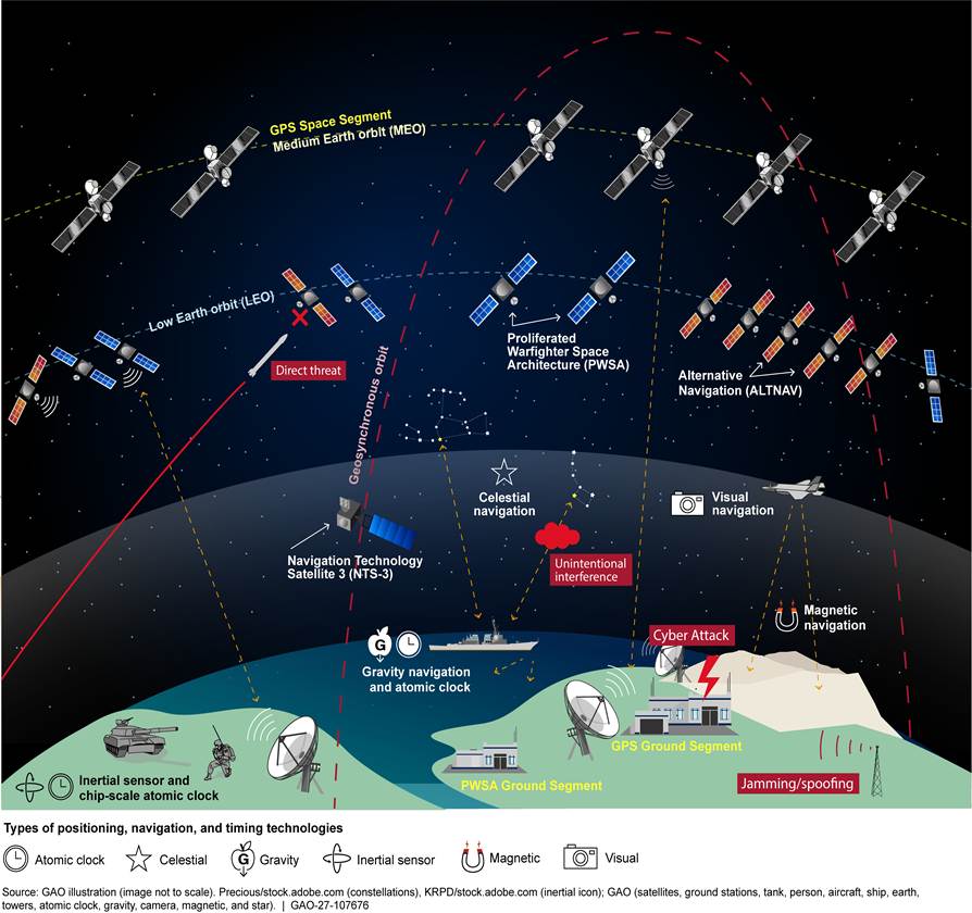
Operational Illustration of Threats to GPS and Complementary Positioning, Navigation, and Timing Systems
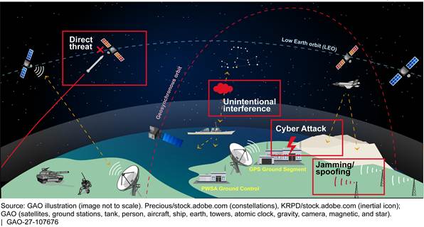
The Air Force continues to make progress developing modernized GPS military code (M-code) receiver cards, but challenges remain with fielding and integration. For example, the M-code aviation receiver programs continue to encounter development and integration challenges. In response, the Navy is developing an interim solution for its aircraft to use M-code. On the other hand, the Army and Navy are fielding M-code capable and multi-PNT receivers in ground vehicles, ships, and Army aircraft. All the military services are also pursuing integration of complementary PNT data into multi-PNT receivers.
Challenges with aligning multiple, fragmented PNT efforts across the military services impact DOD’s ability to ensure that M-code and PNT efforts are completed promptly. Congress mandated a PNT Oversight Council to oversee the portfolio. While the council can make budget-related recommendations to the services, the services are responsible for their own budgets. The PNT enterprise could benefit from consolidating and aligning efforts among the services. DOD has taken some steps to consolidate multiple PNT efforts, such as combining aircraft PNT receivers and M-code receiver card efforts into a single Air Force managed joint program office. Benefits of consolidation could include synchronization of schedules and better strategic alignment of funding.
Why GAO Did This Study
The U.S. military and civilians depend daily on accurate PNT data provided by GPS operated by the Space Force on behalf of DOD. DOD has worked for decades to modernize its GPS, including the use of a new signal—called M-code—and other features to counter evolving threats. Challenges have delayed these efforts. The military services have also started developing and fielding complementary PNT systems to ensure the availability of this foundational military capability.
Congress included a provision in law for GAO to report on DOD’s GPS modernization efforts and development and fielding of complementary PNT efforts. This report (1) addresses the progress DOD has made in modernizing GPS and providing complementary PNT data to the warfighter; (2) discusses the status of DOD efforts to develop and field modernized PNT receivers; and (3) assesses the extent to which DOD has taken steps to oversee the PNT portfolio, and what challenges it is facing.
To conduct this work, GAO reviewed documentation from GPS modernization and complementary PNT programs and efforts and interviewed relevant officials from DOD and the military departments.
What GAO Recommends
GAO is making three recommendations for DOD to ensure that each of the three military departments assesses where consolidation of its GPS modernization and complementary PNT efforts would ensure better strategic alignment between DOD and the military departments and develop plans to consolidate efforts. DOD concurred with GAO’s recommendations.
|
Abbreviations |
|
|
|
|
|
ACNS |
Automated Celestial Navigation System |
|
AEP |
Architecture Evolution Plan |
|
AEP-M |
Architecture Evolution Plan Modernization |
|
ALTNAV |
Alternative Navigation |
|
ASIC |
Application Specific Integrated Circuit |
|
CDD |
Capability Development Document |
|
CIO |
Chief Information Officer |
|
CRPA |
controlled reception pattern antenna |
|
CSIS |
Center for Strategic and International Studies |
|
DAPS |
Dismounted Assured Positioning, Navigation, and Timing System |
|
DDG |
U.S. Navy destroyer |
|
DOD |
Department of Defense |
|
DTE&A |
Developmental Test, Evaluation, and Assessments |
|
EAGLE-M |
Enhanced Aviation Global Air Traffic Management, Localizer Performance with Vertical Guidance, Embedded GPS/Inertial Navigation System M-code |
|
EGI |
Embedded GPS Inertial Navigation System |
|
EGI-M |
Embedded GPS Inertial Navigation System – Modernized |
|
FOC |
full operational capability |
|
GEN |
generation |
|
GMLRS |
Guided Multiple Launch Rocket System |
|
GNSS |
Global Navigation Satellite Systems |
|
GPNTS |
GPS based Positioning, Navigation, and Timing Service |
|
GPS |
Global Positioning System |
|
GPS IIIF |
Global Positioning System III Follow-on |
|
INS |
Inertial Navigation System |
|
IOC |
initial operational capability |
|
Inc |
increment |
|
JASSM |
Joint Air-to-Surface Standoff Missile |
|
LEO |
low Earth orbit |
|
LRASM |
Long Range Anti-Ship Missile |
|
LWS |
lightweight signal |
|
MAGR-2K-M |
Miniature Airborne GPS Receiver 2000 – Modernized |
|
MAPS |
Mounted Assured Positioning, Navigation, and Timing System |
|
MARE |
Military Code Aviation Receiver Enterprise |
|
MAVRC |
Maritime and Aviation Receiver Card |
|
M-code |
military code |
|
MGUE |
Military GPS User Equipment |
|
MLRS |
Multiple Launch Rocket System |
|
MOSA |
modular open systems approach |
|
MTA |
middle tier of acquisition |
|
NTS-3 |
Navigation Technology Satellite-3 |
|
OCS |
Operational Control Segment |
|
OCX |
Next Generation Operational Control System |
|
OUSD (A&S) |
Office of the Under Secretary of Defense for Acquisition and Sustainment |
|
OUSD (R&E) |
Office of the Under Secretary of Defense for Research and Engineering |
|
PGM |
precision guided munition |
|
PNT |
positioning, navigation, and timing |
|
PWSA |
Proliferated Warfighter Space Architecture |
|
R-EGI |
Resilient Embedded GPS/Inertial Navigation |
|
RMP |
Regional Military Protection |
|
SAASM |
Selective Availability Anti-Spoofing Module |
|
SDA |
Space Development Agency |
|
UTC |
coordinated universal time |
This is a work of the U.S. government and is not subject to copyright protection in the United States. The published product may be reproduced and distributed in its entirety without further permission from GAO. However, because this work may contain copyrighted images or other material, permission from the copyright holder may be necessary if you wish to reproduce this material separately.
October 7, 2026
Congressional Committees
The Department of Defense’s (DOD) Global Positioning System (GPS) is the principal source of positioning, navigation, and timing (PNT) information for the U.S. military and civilian users. Due to DOD’s reliance on it, GPS also represents a potential single point of failure for DOD. We previously reported on DOD’s efforts to modernize GPS with a more jam-resistant, encrypted, military-specific signal, referred to as military code (M-code), and we found that DOD is years away from fielding this capability after spending more than 2 decades and billions of dollars.[1] Further, in 2026, DOD canceled development of its multi-billion-dollar effort to develop a modernized ground control system, citing ongoing technical issues.
A variety of threats can disrupt and deny GPS signals, especially in highly congested and contested electromagnetic warfare environments. For example, when Russia invaded Ukraine, Russia used jamming to degrade GPS, hindering Ukraine’s use of some of the U.S.-provided precision guided munitions. Moreover, both nations successfully used spoofing, a technique to create deceptive GPS signals, to disrupt actual GPS signals. In response to threats like these, DOD is simultaneously developing, procuring, and fielding complementary PNT systems that are not dependent on the availability of GPS signals, while continuing its M-code efforts.
The National Defense Authorization Act for Fiscal Year 2025 includes a provision for us to report on DOD’s GPS modernization efforts and development and fielding of complementary PNT efforts.[2] This report: (1) addresses progress DOD has made in modernizing GPS and providing complementary PNT data to the warfighter; (2) discusses the status of DOD efforts to develop and field modernized PNT receivers; and (3) assesses the extent to which DOD has taken steps to oversee the PNT portfolio, and what challenges it is facing.
For all our objectives we reviewed documentation—such as program status briefings, budgets, and schedules—and conducted interviews with relevant officials from DOD, the Army, Navy, Marine Corps, Air Force, and Space Force. To assess the progress in modernizing GPS and providing complementary PNT data to the warfighter, we obtained updated schedule, cost, and risk status information from the GPS program offices. We discussed the program status for DOD’s efforts with officials from DOD’s Office of Developmental Test, Evaluation, and Assessments.
To determine the status of DOD’s efforts to develop and field modernized PNT receivers and M-code-capable receiver cards, we interviewed department and military service officials responsible for overseeing these efforts. For each identified effort, we obtained information and documents about the program’s planned capabilities, schedule, key milestones, budgets, remaining risks, and challenges.
To determine how DOD is overseeing PNT and identify the challenges it is facing, we evaluated DOD documents and conducted interviews to understand the oversight structure and the scope of the GPS modernization and complementary PNT efforts. We assessed this information against DOD’s portfolio management practices and leading practices in Agile portfolio management that we identified in prior work.[3] We also analyzed the meeting minutes from the body charged with oversight of DOD’s PNT efforts, known as the PNT Oversight Council, to determine the main focus of those meetings. In addition, we obtained the views of program officials about the level of guidance and communication provided through the PNT oversight structure and to identify any challenges faced by the programs. Additional information on our objectives, scope, and methodology can be found in appendix I.
We conducted this performance audit from July 2024 to October 2026 in accordance with generally accepted government auditing standards. Those standards require that we plan and perform the audit to obtain sufficient, appropriate evidence to provide a reasonable basis for our findings and conclusions based on our audit objectives. We believe that the evidence obtained provides a reasonable basis for our findings and conclusions based on our audit objectives.
Background
DOD’s GPS Enterprise
Both military and civilian users in the United States depend on assured and accurate PNT information to support military operations and critical defense and civil infrastructure. GPS, available worldwide, is the primary source of this PNT information and is operated by the U.S. Space Force on behalf of DOD.
GPS consists of three segments:
· a space segment consisting of a constellation of approximately 31 medium Earth orbiting satellites, with at least 24 continuously broadcasting satellite position and time data,
· a ground control segment for command and control of the satellite constellation, and
· a user segment, comprised of receivers used by the military and civilians in aircraft, ships, land vehicles, precision guided munitions, and handheld devices.
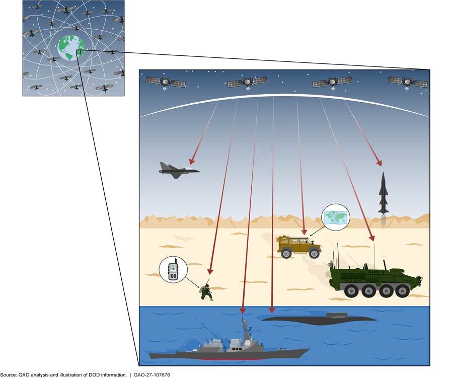
DOD began developing a space-based navigation satellite constellation in the 1970s. The system was initially available only to U.S. Navy vessels using large receivers. By the 1991 Persian Gulf War, GPS equipment was small and inexpensive enough to also be used on aircraft and other military vehicles. Since then, further advances, such as the development of even smaller microchip-sized receivers, have allowed GPS to provide precise PNT information for individual soldiers, munitions, smaller weapons technology applications, and civilian applications, like smartphones. Figure 1 shows different uses of the GPS satellite constellation by U.S. military forces.
Since 2000, the Air Force—and later the Space Force—pursued a multi-billion-dollar effort to modernize and sustain the existing GPS capability and enhance the current GPS system. The modernization effort included adding a more robust and more securely encrypted GPS military signal capability, known as M-code. The efforts to modernize GPS also include:
1) satellites that broadcast the M-code signal,
2) a ground system that controls both the existing and new M-code GPS satellites, and
3) user equipment to receive the M-code signals.
The first satellites capable of broadcasting M-code have been on orbit since 2005, with the upgraded versions, referred to as GPS IIIF, being manufactured now. The ground system, referred to as Next Generation Operational Control System (OCX), began development in 2010. Development of new receivers for user equipment began in 2017. Our prior work has shown, however, that the GPS modernization efforts experienced schedule delays of up to a decade and longer as well as up to billions of dollars in cost increases.[4]
Until recently, the Space Force managed all three GPS modernization segments. The two user equipment efforts were transferred from the Space Force to the Air Force in 2024 and 2025.[5] Pursuant to a mandate in the National Defense Authorization Act for Fiscal Year 2024, in November 2024, DOD transitioned the Military GPS User Equipment (MGUE) Increment 1 (Inc 1) program from the Space Force to the Air Force. In April 2025, an Assistant Secretary of the Air Force memorandum noted that the Space Force and Air Force also agreed to transition the MGUE Increment 2 (Inc 2) effort to the Air Force. According to program officials, the MGUE Inc 1 and Inc 2 efforts started transferring to the new program office, the Air Force M-code Aviation Receiver Joint Program Office, in December 2025. Officials from the program office stated they completed the transition of the MGUE efforts in May 2026.
Threats to GPS and DOD’s Efforts to Mitigate Them
GPS signals are being actively targeted by adversaries who seek to disrupt or deny GPS to U.S. warfighters. These threats include (1) jamming, (2) spoofing, (3) cyber, and (4) direct attacks on satellites or satellite infrastructure. GPS signals and other PNT sources can also be impacted by unintentional interference through natural phenomenon or via human causes such as signals on a similar frequency band. See figure 2 for descriptions of these threats.
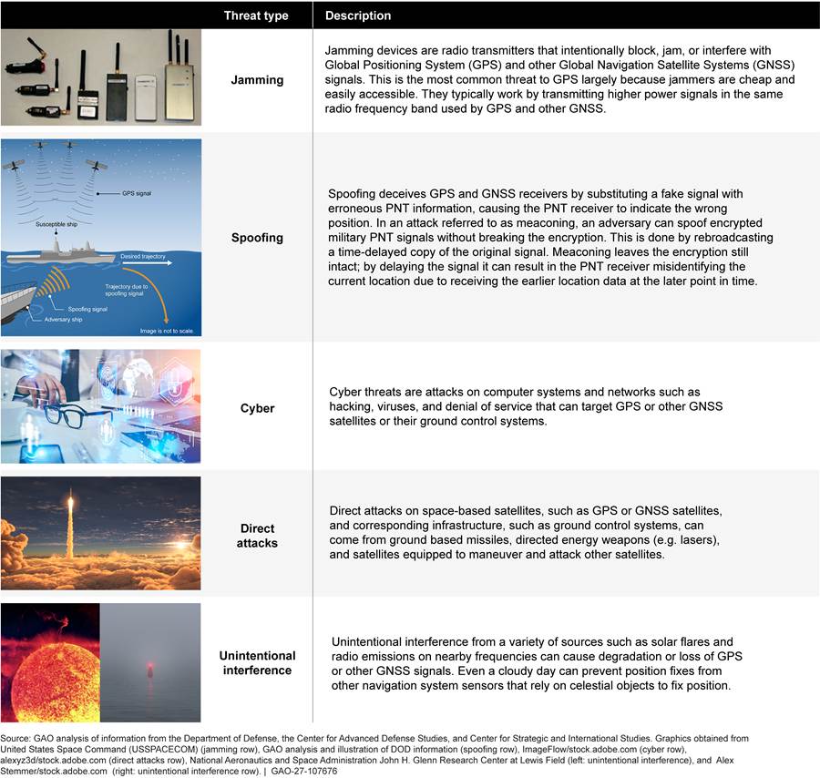
DOD has various approaches to manage and mitigate these threats. For example:
· DOD is mitigating jamming attacks by installing specialized antennae—referred to as controlled reception pattern antennae (CRPA)—on weapon systems and munitions. These antennae provide the ability to identify and filter out the jamming signals. DOD also designed the M-code signals to be more jam resistant than the existing GPS signals. Finally, DOD designed the future GPS IIIF satellites to be able to broadcast a steerable, boosted M-code signal, a capability known as Regional Military Protection, that will further mitigate against adversarial jamming.
· DOD is managing the risks of spoofing attacks, in part by developing and installing receivers with M-code capability, which will provide more secure encryption.
· DOD is mitigating the risks of cyberattacks by ensuring that computer systems and networks are protected against cyberattacks that can target satellites and their associated ground control systems.
· DOD is mitigating the risks posed by direct attacks to GPS satellites by building resilient and redundant capabilities, such as low Earth orbit (LEO) PNT-capable satellite constellations and associated infrastructure.[6]
Impact of GPS Threats on Military Operations
While DOD has ways to manage and mitigate threats to GPS, these measures can have limited effectiveness in environments where GPS signals are under heavy attack to disrupt and deny the service to U.S. warfighters. In April 2025, the Center for Strategic and International Studies reported in its Space Threat Assessment 2025 that GPS jamming and spoofing were becoming more widespread in areas of active military conflict.[7] The report also noted that these GPS jamming and spoofing attacks reduced the effectiveness of precision guided munitions (PGM) and drones that rely on GPS to find their targets within these GPS-contested environments. In addition, the April 2025 Global Counterspace Capabilities report from the Secure World Foundation noted that, in eastern Ukraine from 2023 to 2024, intensified GPS jamming negatively affected several PGMs that relied on GPS to locate their targets.[8] In one case, a specific type of PGM was rendered up to 80 percent less effective in hitting designated targets. Even when jamming countermeasures were applied, at least one other type of PGM was still disrupted from hitting its targets up to 40 percent of the time.
Complementary PNT in Response to GPS Threats
According to DOD’s Office of the Under Secretary of Defense for Research and Engineering, OUSD (R&E), to mitigate the threats to GPS, “a diverse array of technologies is required to meet current and future DOD PNT requirements.”[9] DOD’s complementary PNT efforts are comprised of three broad categories of systems designed to work in conjunction with GPS.
· Satellite-based PNT, specifically LEO satellites that provide PNT signals that can be received and interpreted by ground-based receivers that are similar to GPS (e.g., the Space Development Agency’s (SDA) Proliferated Warfighter Space Architecture (PWSA) and the Army’s Alternative Navigation—ALTNAV—system).[10]
· Non-satellite-based PNT using data derived from internal or external sources of information to sensors, from geophysical sources, or from celestial sources (e.g., inertial measurement units, cameras or terrain sensors, magnetic or gravity sensors, and celestial sensors).[11]
· Holdover time sources, such as chip-scale atomic clocks, that allow for synchronized timing in case contact with the standardized coordinated universal time (UTC) signal is lost.[12]
To field complementary PNT capabilities, the military departments—the Army, Navy, and Air Force—are developing and procuring several different models of PNT receivers that can receive M-code along with complementary PNT signals or data. We refer to these receivers as multi-PNT receivers. The departments are developing and fielding these multi-PNT receivers to meet the needs of weapon systems in the ground, aviation, and maritime domains. In simplified terms, a multi-PNT receiver is a box that is placed on a weapon system, such as a ship or aircraft. The multi-PNT receiver box contains multiple PNT receiver cards, with different PNT capabilities, which can be installed and changed out depending on the capability needed. In addition to the GPS M-code signal, multi-PNT receivers may also collect information from other PNT components or sensors on the weapon system or munition, such as antennae for a complementary PNT radio frequency signal, or acceleration and rotation data from an inertial measurement sensor. Figure 3 shows how various complementary PNT capabilities can be included in a multi-PNT receiver.
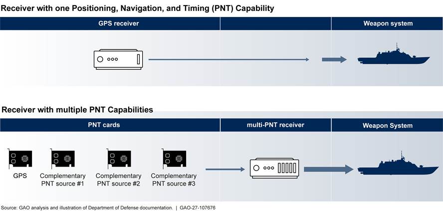
Some examples of these complementary PNT sources include (1) a celestial sensor that works by measuring angles of several celestial objects to calculate a position, and (2) receivers for signals from systems operated by commercial satellite companies. In addition to the multi-PNT receiver efforts underway, DOD has ongoing efforts to provide other sources of complementary PNT that use either a commercial satellite constellation or a government satellite constellation to provide PNT signals. These complementary PNT sources are either operating now or are expected to be operating within the next few years to provide these new PNT capabilities to warfighters. We discuss these complementary PNT sources subsequently in the report.
DOD PNT Oversight
DOD established the PNT Oversight Council in 2016, in response to a 2015 statute.[13] The statute established the council to be responsible for oversight of DOD’s PNT enterprise and fulfill several specific responsibilities including risk mitigation and resource prioritization. The council is comprised of three levels of leadership, as shown in figure 4.
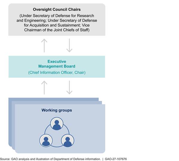
DOD’s Chief Information Officer (CIO), along with being the chair of the Executive Management Board, is also the principal staff assistant for PNT policy. In this role, the DOD CIO is responsible for the development and coordination of DOD’s positions on all aspects of PNT. Additionally, each military service has a group that coordinates its complementary PNT efforts and represents its respective military service on the PNT Oversight Council and Executive Management Board, and at working group meetings.
Delays Have Continued for Ground and Space Segments of GPS Modernization While DOD Has Continued Efforts to Add Complementary PNT Tools
DOD Termination of the OCX Program Follows Years-Long Delays in Delivering Fully Capable Ground System
Space Force Initially Accepted the System, but Recognized Deficiencies
The Space Force formally accepted OCX from the contractor in July 2025.[14] However, officials reported that this acceptance occurred after the Space Force agreed to multiple waivers and deviations—some of which related to technical shortfalls. Several pre-acceptance tests had been completed on the system. Specifically, according to officials with DOD’s Office of Developmental Test, Evaluation, and Assessments (DTE&A), the system met its key performance parameters and key system attributes required for system acceptance, with one notable exception. In particular, DTE&A officials stated that the requirement for time-steering—a feature that pertains to the system’s ability to ensure accurate time dissemination—was not met and a waiver was granted.[15] As a work-around, the program relied on the existing GPS Operational Control Segment – Architecture Evolution Plan (OCS-AEP) ground control system to conduct time-steering during testing, according to DTE&A officials. These officials further noted that OCX would have to satisfy this time-steering requirement prior to transferring operational control of the GPS satellite constellation to it. Additionally, while DTE&A officials stated that they supported the Space Force’s acceptance of OCX, they assessed cyber survivability as a high-risk area, requiring continued mitigation and focused investment. The Space Force had prioritized completing development for the delayed OCX effort and had originally planned to achieve readiness to transition to operations by June 2017. The program had witnessed numerous technical challenges resulting in protracted delays. We reported on these technical challenges and delays, as in September 2024.[16]
Air Force Determined Incremental Modification of Existing Ground System Offered Lower Risk Option than Addressing OCX Deficiencies
In April 2026, DOD’s Office of the Under Secretary of Defense for Acquisition and Sustainment, OUSD (A&S), directed the Air Force to formally terminate the OCX program. Following the November 2025 completion of studies into OCX and potential OCS-AEP-based alternatives, Space Force officials stated, the Air Force Service Acquisition Executive for Space, with Space Force support, requested that DOD cancel the OCX program. Space Force analysis determined that completing OCX was a higher risk than modifying OCS-AEP and supported the recommendation to cancel OCX. According to Space Force officials, the studies showed that either OCX or a modified OCS-AEP would deliver most PNT capabilities within the same 2028-2029 time frame, although the projected 2030 completion of cybersecurity upgrades and modernized civilian signal capabilities with OCS-AEP would lag behind the OCX schedule. They stated, however, that OCX was higher risk due to the unknown number of deficiencies that would need to be resolved. As the Space Force awaited the termination decision on OCX, the program experienced further delays until the program staff halted activities.
In its decision to terminate OCX, the OUSD (A&S) designated AEP Modernization (AEP-M) as the new GPS ground control effort to deliver modernized PNT capabilities and cybersecurity enhancements. The Space Force plans to conduct the AEP-M program as a multi-phase modification to OCS-AEP. Given congressional interest in the program and the program’s critical nature and technical complexity, the Under Secretary of Defense for Acquisition and Sustainment will be the program milestone decision authority. OUSD (A&S) directed the Air Force Service Acquisition Executive for Space to provide twice yearly updates on the status of the AEP-M program.
Efforts to Develop New GPS Satellites Experienced Continued Schedule Growth, but Made Progress Addressing Some Risks to Future Efforts
As the GPS IIIF program worked through technical challenges, it experienced delays to the projected satellite deliveries. As of September 2026, the program’s projected deliveries of the first 10 GPS IIIF satellites reflect an average delay of 9 months since the program implemented a revised delivery schedule in December 2024. According to DOD documents, factors such as the late delivery of components and testing constraints contributed to these delays. Even with the shifts in the projected delivery dates, these deliveries are ahead of the dates in the GPS IIIF program’s acquisition program baseline schedule. And despite the delays, as of September 2026, the first GPS IIIF satellite delivery—the third unit procured—was projected to occur in July 2027. As we reported previously, however, the program’s baseline schedule may not meet the Space Force’s requirement for keeping 24 operational M-code-capable satellites on orbit.[17]
The DOD decision on the OCX program creates schedule risk for the incorporation of these satellites into the GPS constellation, according to program officials. The Space Force had intended to use capabilities from the now-canceled OCX program for GPS IIIF satellite control, and the program was preparing for launch, checkout, and operations with OCX software.[18] In April 2026 and July 2026, however, the Space Force awarded contracts to modify OCS-AEP to launch and operationally control GPS IIIF satellites as part of the Space Force’s AEP-M efforts. The transition to this non-OCX-based capability will require further software work. To support the planned launch of the first GPS IIF satellite in 2028, GPS IIIF program officials stated in February 2026 that they would need ground control capabilities by early 2027.
The GPS IIIF program made progress reducing development risk in major components for its GPS IIIF satellites. For example, in mid-2025, the program completed qualification testing for the design of the Mission Data Unit, a critical element to the GPS IIIF satellite’s navigation mission. Subsequently, the program took delivery of two flight Mission Data Units, with the first in September 2025 and the second in December 2025. Similarly, the program also took delivery of two shipments of subcontractor-supplied Linearized Traveling Wave Tube Amplifiers, with the first in September 2025 and the second in December 2025. The contractor installed this hardware on two GPS IIIF satellites, allowing one of these satellites to begin its initial system performance testing in December 2025. Thermal vacuum testing for this satellite was started in August 2026.
DOD Is Continuing to Develop Complementary PNT Systems to Mitigate GPS Threats
DOD is using and continuing to develop complementary PNT capabilities that are designed to augment GPS and, if necessary, fill in when GPS is disrupted or denied. Some of these capabilities are available now and others are being developed to be fielded within the next few years. These systems include (1) satellite-based PNT systems, (2) non-satellite-based positioning and navigation, and (3) backup timing solutions. In the near term, Army and SDA efforts to provide two new satellite-based navigation signals from LEO constellations will provide additional capabilities should the current constellation of GPS satellites be unable to provide signals to military forces. Other PNT technologies designed to augment GPS, as well as to provide PNT information in the event that GPS is unavailable, are being developed and readied for incorporation into PNT receivers. We discuss those receivers later in this report.
Satellite-Based Complementary PNT
DOD and the military services are developing, and in some cases already operating, new satellite-based PNT options. Like GPS, these rely on radio frequency transmissions of data. Unlike the GPS constellation that operates in medium Earth orbit, these newer satellite constellations are in LEO. While such systems could be subject to the same threats as GPS, such as jamming and spoofing, warfighters could also benefit from stronger PNT signals from LEO satellites, which are closer to Earth. Such complementary PNT systems include the following:
· Army’s ALTNAV. The Army’s ALTNAV leverages a commercial LEO satellite constellation and an Army-developed ground control segment. These provide a complementary PNT capability to the warfighter in operating environments where GPS access is disrupted or denied. After completing operational testing, ALTNAV achieved its initial operational capability in late 2024 and full operational capability is expected by mid-2027. For full fielding of ALTNAV, the Army needs to complete its deployment of globally dispersed ground stations, according to program officials. These stations are to monitor and collect data transmitted by the satellites to facilitate data corrections. In 2025, the Army reported that it was working to secure permission to complete installation of ALTNAV ground monitoring stations across the globe, and this may be a challenge.
· SDA’s PWSA. SDA is developing PWSA as a network of LEO satellite constellations connected to a multi-mission ground segment.[19] It is developing this satellite constellation in successive tranches with different capabilities. SDA aims to provide a variety of capabilities to the warfighter, including tactical communications, missile warning, missile tracking, and data processing. In the area of PNT, SDA plans to deliver an optical timing/ranging capability to the warfighter by 2027 with the PWSA Tranche 1 satellites, which began launching in 2025. SDA plans for PWSA to provide another complementary PNT capability through a lightweight satellite navigation (LWS) signal to be broadcast beginning with its Tranche 3 satellites.[20] Warfighter use of this PNT capability will require PNT receiving equipment programmed to receive this LWS signal. Initial operational capability for the LWS complementary PNT capability is projected for 2030, according to SDA officials.
· Air Force’s Navigation Technology Satellite 3 (NTS-3).[21] The Air Force launched its NTS-3 satellite in August 2025 with the mission of testing a variety of experimental satellite-based PNT technologies. These include a capability to “steer” the broadcast signal to focus on a specific geographical region on Earth, as well as a navigation payload with the ability to reshape the waveform of the PNT signal itself via commands from the ground. Additionally, NTS-3 is supplied with multiple atomic clocks that will be used to test the ability to use an ensemble of clocks to automatically detect and correct timing signal errors. NTS-3 will also test trusted data delivery for multi-Global Navigation Satellite Systems.[22] These technological experiments will help inform potential future directions for satellite-based PNT systems.
Non-Satellite-Based Complementary PNT
DOD is also engaged in efforts to modernize and develop non-satellite, sensor-based positioning and navigation technologies. These technologies employ a range of sources—such as inertial, visual, celestial, magnetic, and gravity data inputs. Some of these positioning and navigation sources, such as celestial and visual, have a history of operational use by the military services. However, DOD is seeking to advance the utility of these options by refining the reference data upon which such positioning and navigation technologies rely. Below we discuss several of these categories of positioning and navigation tools.
· Inertial tools. DOD has long used data from inertial sensors for positioning and navigation data and is taking steps to modernize these tools. Inertial-based sensors work by measuring the movement of an aircraft, ship, or vehicle in terms of its direction, acceleration, and orientation. The measurements of an inertial-based sensor can be combined with externally sourced reference positioning data, typically from GPS, to improve the sensor’s accuracy. DOD research and development offices, such as the Air Force Research Laboratory, are investing in modernized, sensor-based devices called inertial measurement units with the intent of providing increasingly more accurate inertial navigation data over longer periods of time than current sensors. GAO previously reported that the accuracy of navigation data from inertial measurement units tends to degrade the longer it has been since the receiver obtained its externally-sourced reference data.[23] The variance from the inertial measurement unit’s measured position to the weapon system’s actual position is referred to as drift. Inertial navigation sensors provide the advantage of being self-contained and, for a period of time, non-dependent upon any external data source after the reference coordinates are provided. Positioning data from external PNT sources are commonly used to periodically correct the drift of an inertial navigation device.
· Geophysical tools. DOD is advancing the use of detailed geophysical data, such as maps of Earth’s terrain and magnetic or gravitational fields. DOD loads this information into a specialized navigation system on a weapon system as reference data to determine position and conduct navigation. For example, an aircraft equipped with this type of navigation system would use its onboard camera sensors to collect images of its surroundings as it flies toward its target. These collected images are compared to its onboard image reference data map to determine its position. A similar process can also be used with magnetic or gravity sensor data compared to the loaded magnetic or gravity reference data map on the aircraft. These navigation systems, combined with the detailed mapping data, can provide positioning and navigation capabilities without depending on external signals like GPS. DOD has assigned responsibilities for the maintenance of reference data for some of these positioning and navigation sources. For example, the National Geospatial-Intelligence Agency is responsible for maintaining models of Earth’s gravity and magnetic fields. Whereas current magnetic and gravitational navigation is less accurate than GPS, visual navigation can provide positioning and navigation accuracy that is nearing GPS levels (accurate up to 10 meters), when enabled with the correct geophysical reference data.
· Celestial tools. Navigation using celestial tools uses the position of celestial bodies—such as stars, planets—and human-made satellites to determine a user’s position on Earth at a specific point in time. DOD has been using celestial navigation on certain weapon systems for decades. Currently, DOD is pursuing modernized sensors for tracking relevant celestial objects, while also refining highly detailed reference mapping of celestial objects. These sensors and the celestial map data are integrated with specialized navigation systems that can compare the real-time celestial imaging from the sensors against the celestial mapping reference data to determine positioning. The U.S. Naval Observatory is responsible for maintaining DOD’s authoritative database of celestial data.
While such sensor-based sources of positioning and navigation data can serve as an alternative when GPS is rendered unavailable or unreliable, these technologies are typically less accurate than GPS. Their utility is also dependent on operating domain and prevailing conditions. For example, visual navigation requires visually recognizable features to function. In areas characterized by featureless visual characteristics, such as above an ocean, across a desert, or over a dense forest, visual navigation technology can be largely unusable. Similarly, use of celestial navigation depends on a relatively clear view of the skies.
Back-up Timing Solutions
DOD developed and fielded alternative timing solutions as back-ups to GPS timing. GPS signals disseminate precise timing using the coordinated universal time (UTC) data, which are derived from the DOD master clock at the U.S. Naval Observatory. These data are the time reference information necessary to develop positioning information from GPS satellite signals. When GPS signals are unavailable, the absence of the timing data can also interfere with communications and networking. In response to a potential loss of the UTC data through threats to GPS, DOD developed and fielded backup precise timing systems to provide holdover time solutions. These include the following:
· Defense Regional Clocks function as an alternative source for the UTC time that is derived from the U.S. Naval Observatory. These clocks are designed to provide timing data on military installations during periods when UTC data from GPS are disrupted.
· Atomic clocks, including those that are chip-sized, are self-contained and can be installed on systems requiring timing data. According to DOD documentation, reducing the cost of these clocks to be able to field them on a wide array of weapon systems is a current DOD objective.
Figure 5 illustrates how the three GPS segments—space, ground, and user—are envisioned to work while under threat in an operational environment in conjunction with several complementary PNT sources and sensors.
Challenges Continue with Developing and Fielding M-code Receiver Cards and Modernized PNT Receivers, but the Services Are Making Some Progress
The Air Force continues to face technical and schedule challenges with the development of M-code receiver cards. At the same time, the military services are developing and fielding M-code-capable receivers for munitions. Challenges and delays remain with the development of M-code-capable aviation receivers, but the Navy is developing an interim solution to allow its current aviation receivers to receive M-code. While their fielding timelines vary, the military services are pursuing the integration of complementary PNT capabilities into several M-code capable multi-PNT receivers.
Air Force Continues to Face Technical and Schedule Challenges with Development of M-code Receiver Cards
The MGUE Inc 1 program’s aviation/maritime card completed certifications for both lead platforms, but the program identified a technical challenge with the maritime platform. The contractor resolved the technical challenge via a software update. During the certification process for the aviation card, the program determined that an update to the aviation accuracy requirements were needed, and updates are in progress. The MGUE Inc 2 program has made progress in developing the receiver card that houses the MGUE Inc 2 chip. The MGUE Inc 2 program plans to develop a new lower-power Inc 2 receiver card for aviation and maritime platforms.
Increment 1 Aviation/Maritime M-code GPS Receiver Card Progress and Challenges
The MGUE Inc 1 program completed significant aviation/maritime card-level certifications for both the Navy and Air Force lead platforms in September 2024 and August 2025, respectively. For the aviation/maritime variant card, the milestone decision authority certified the card for use on the Arleigh Burke Class Destroyer (DDG), but integration challenges remained at the time of certification. According to program officials, the integration challenges were resolved in December 2025. Program officials also noted that for the aviation platform, the Air Force and Army agreed to switch the lead aviation platform from the Air Force B-2 Spirit bomber to the Army’s Gray Eagle uncrewed aircraft system. Certification testing confirmed that the card worked, but the card’s accuracy did not meet the Capability Development Document (CDD) requirements.[24]
The MGUE Inc 1 program office experienced software stability issues with variants of MGUE Inc 1 aviation/maritime receiver cards used for initial testing. According to program officials, the program identified a new deficiency during aviation/maritime card-level certification for the Navy’s DDG lead platform that persisted from September 2024 to December 2025. Program officials noted a discrepancy with the DDG’s receiver card triggering a Position, Velocity, and Time Assurance outage error, which paused the Navy’s plans to integrate the card into its ships. However, officials stated the program office worked with the vendor to correct the issue with a software update and planned to conduct additional testing in April 2026 and May 2026. Once testing shows the technical solution is successful, the Navy plans to conduct further operational testing in May 2027, based on ship availability. It then plans to begin integrating the maritime variant M-code receiver card into its ships beginning in fiscal year 2027.
As noted above, the Space Force changed the lead aviation platform to the Army’s Gray Eagle uncrewed aircraft system for the MGUE Inc 1 receiver card testing.[25] The Space Force is updating the MGUE Inc 1 CDD requirements to less stringent ones. According to officials, the Gray Eagle aviation/maritime card certification meets maritime accuracy requirements, but it does not meet the more stringent joint aviation accuracy requirements in the current MGUE Inc 1 CDD. The Gray Eagle testing demonstrated that the MGUE Inc 1 receiver card certification meets the less stringent Selective Availability Anti-Spoofing Module (SAASM) requirements.[26] Program officials stated that the current SAASM requirements are sufficient for Gray Eagle mission success and the more challenging requirements contained in the CDD are not needed. According to program officials in June 2026, the program, with approval from the Joint Requirements Oversight Council, updated its CDD requirements to match the SAASM requirements.
Increment 2 M-code GPS Receiver Card Progress
The MGUE Inc 2 card program continues to make progress in software development of the miniature serial interface card and the M-code Application Specific Integrated Circuit (ASIC) receiver card for future deployment into modernized PNT and multi-PNT receivers.[27] We reported in September 2024 that the MGUE Inc 2 program began in 2020 as a middle tier of acquisition (MTA) prototyping effort and expected to complete the effort within 5 years of the program start.[28] Program officials reported that the MGUE Inc 2 receiver card MTA effort completed all requirements under the existing MTA effort and entered the software acquisition pathway in November 2025 to finalize the MGUE Inc 2 development.
According to program officials, current MGUE Inc 2 development efforts are focused on ground handheld applications. However, they noted that the MGUE Inc 2 receiver card will enable the use of future capabilities such as receiving the boosted Regional Military Protection (RMP) signals along with PNT signals from other global navigation satellite systems.[29] Program officials stated that RMP will be implemented in the final software build of the MGUE Inc 2 program, with a formal qualification test planned for the end of fiscal year 2027. In addition to handheld receivers, program officials anticipate the MGUE Inc 2 receiver chip will also be capable of being adapted and integrated into aircraft and ships. The program is planning to develop the Maritime Aviation Receiver Card (MAVRC)—a next-generation, low-power GPS receiver design based on the MGUE Inc 2 technology—intended for aviation and maritime uses. According to program officials, MAVRC will include aviation/maritime requirements that will be appended into the MGUE Inc 2 CDD and will be available to the services by 2032.
Progress Made on Development of GPS Receivers for Munitions and an Interim Solution for Navy, but Challenges Remain for Aviation Receivers
The Army, Navy, and Air Force are integrating MGUE Inc 1 receiver cards into several of their precision guided munitions. The Navy is developing an interim capability for its aircraft to receive M-code signals by integrating MGUE Inc 1 receiver cards into its existing aviation receivers due to delays with an Air Force managed M-code aviation receiver program. However, the military services face challenges and delays with the development and fielding of their aviation receivers.
The Services Are Making Progress in Developing and Fielding M-Code Receivers for Munitions Programs
The military services have prioritized modernizing and fielding their munitions with M-code GPS receivers. Many of the current military service munitions are being developed with the MGUE Inc 1 M-code receiver card, while waiting for the MGUE Inc 2 card to become available for integration into their specific munitions. However, due to the contractor shutdown of the MGUE Inc 1 ASIC production line, there is a limited supply of the M-code chips available. Table 1 highlights several of the military service munitions dependent on the MGUE Inc 1 card and highlights their estimated initial operational capability (IOC) dates.[30]
|
Munitions |
Military service |
Estimated IOC (fiscal year) |
|
Artillery shells |
|
|
|
Excalibur, Excalibur Hit-to-Kill |
Army/Marine Corps |
2027 |
|
Precision Guidance Kit |
Army/Marine Corps |
2027 |
|
Long Range Precision Guidance Kit |
Army/Marine Corps |
2030 |
|
Ground- and ship-launched rockets and missiles |
||
|
Multiple Launch Rocket System (MLRS) – Guided MLRS (GMLRS) |
Army/Marine Corps |
2029 |
|
Extended Range MLRS / GMLRS |
Army |
2029 |
|
Precision Strike Missile |
Army |
2031 |
|
Tomahawk Land Attack Missile |
Navy |
2028 |
|
Standard Missile 6 |
Navy |
2029 |
|
Air-launched missiles, torpedoes, and bombs |
|
|
|
Joint Air-to-Surface Standoff Missile Extended Range (JASSM-ER) |
Air Force |
2027 |
|
Stand-in Attack Weapon |
Air Force |
2029 |
|
Hypersonic Attack Cruise Missile |
Air Force |
2029 |
|
Long Range Anti-Ship Missile (LRASM) |
Navy/Air Force |
2026a |
|
High Altitude Anti-Submarine Warfare Weapon Capability |
Navy |
2032 |
|
Small Diameter Bomb-I and II |
Navy/Air Force |
2028 |
Source: GAO summary of Department of Defense information. │ GAO‑27‑107676
aLRASM may slip to 2027 to align with the JASSM-ER estimated IOC date.
Navy Is Developing an Interim M-code-Capable Aviation Receiver Solution
The Navy is taking interim steps to ensure its aircraft can receive and use GPS M-code signals more quickly due to challenges and delays with the development of the Air Force managed M-code-capable aviation receivers. In 2024, we reported that the Navy plans to refresh its current Embedded GPS Inertial Navigation System aviation receivers to accept M-code data using the MGUE Inc 1 receiver card or a derivative card. To do this, the program plans to use a preexisting Air Force contract for the Navy’s aircraft. According to program officials, current interim M-code development is being performed using engineering change proposals on current procurement contracts.[31] Engineering change proposals allow each aircraft to handle any potential changes in airworthiness certification by leveraging the existing aviation receiver interfaces and framework, resulting in quicker certification and fielding than a new M-code aviation receiver program would likely require. Figure 6 illustrates the Navy’s estimated IOC dates for select Navy aircraft using the interim M-code receivers under development.

Challenges Remain in Developing and Fielding Modernized M-Code-Capable Aviation Receivers
The Air Force and Army continue to experience funding, software, and integration challenges in the development and fielding of their M-code GPS aviation receiver programs. These challenges contributed to the delay in fielding M-code-capable receivers for Air Force, Navy, and Army aircraft. As we reported in 2024, officials from the office of DOD’s Chief Information Officer stated that aircraft are the most challenging weapon systems to integrate with M-code receivers due to the complexity of integrations with flight software and achieving airworthiness certification. The aircraft integration challenges have led to significant delays and long fielding timelines for various aircraft platforms, especially Army aviation platforms.
The following is a discussion of the challenges that program officials identified with the three Air Force M-code aviation receiver programs and the Army’s M-code aviation receiver program:
· Embedded GPS Inertial Navigation System Modernized (EGI-M): In 2024, we reported that the Air Force worked with two contractors to restructure the development of the modernized EGI receivers. According to program documentation, the Air Force, however, allowed the EGI-M development contract with one contractor to expire in 2024 because that contractor did not deliver a realistic, updated development schedule as required. The loss of the one contractor, the manufacturer of one of the Navy’s EGI receivers, created a challenge for the program to replace its EGI receiver with the EGI-M for the Navy aircraft. This led to the Navy development of an interim M-code aviation receiver as previously discussed.
The Air Force continues to work with the remaining EGI-M contractor on program funding shortalls and software development. According to program officials, the contractor underestimated the complexity of several software capabilities relating to the security and airworthiness certification for the EGI-M receiver. In addition, according to program documents and officials, funding shortfalls have prevented the contractor from maintaining the necessary staff to complete development in a timely manner, resulting in schedule delays. Air Force officials stated that the production representative units were delivered to the Government in March 2026, with a production decision, now estimated for mid-2028 for the Navy’s E-2D and Air Force’s F-22 aircraft variants, and 2030 for the Navy’s F-18 aircraft variant. EGI-M initial fielding is expected to follow in March 2032.
· Resilient Embedded GPS/Inertial Navigation (R-EGI): The Air Force continues to experience software development, integration challenges, and schedule delays with the R-EGI receiver. As we reported in September 2024, the program replaced one subcontractor with another in November 2023.[32] According to program documents, the current contractor is encountering similar challenges as the previous contractor in developing and integrating key components of the R-EGI multi-PNT receiver. The components that continue to present challenges are the Mission Capability Navigation Card and Inertial Measurement Unit that work together to calculate safe navigation solutions with or without GPS. Despite these issues, the program office expected to receive a production representative R-EGI unit for developmental testing in the second quarter of fiscal year 2026. Program officials stated that the program currently plans for a full-rate production decision to follow in the fourth quarter of fiscal year 2027.
· Miniature Airborne GPS Receiver 2000 Modernized (MAGR-2K-M): The Air Force continues integration work of the MGUE Inc 1 receiver card into the MAGR-2K-M M-code receiver, but the program office noted that funding issues impact its ability to complete integration and testing for MAGR-2K-M’s intended aircraft. In addition, according to program officials, the contractor continues to experience challenges in subcontractor management as it relates to integrating the MGUE Inc 1 card into the MAGR-2K-M receiver boxes along with the production of the receiver boxes. However, Air Force officials stated that the MAGR-2K-M receiver box successfully completed initial qualification testing. The program estimated that it will complete developmental testing by March 2026. The program expects to start fielding the MAGR-2K-M in September 2027 with the Navy’s E-6B aircraft.
· Enhanced Aviation, Global Air Traffic Management, Localizer Performance with Vertical Guidance, Embedded GPS/Inertial Navigation System M-code (EAGLE-M): The Army developed the EAGLE-M receiver as a replacement for its legacy EGI receivers that relied on the SAASM-embedded GPS receiver. The EAGLE-M program developed the EAGLE-M receiver by integrating a common M-code GPS receiver card into its legacy EGI avionics architecture. The EAGLE-M program achieved airworthiness qualification in April 2024 and started initial fielding in November 2024 on the Army’s UH-60M Black Hawk helicopter. Army officials stated the EAGLE-M avionics system, with an embedded MGUE Inc 1 receiver card, has been fielded on the Army’s Gray Eagle uncrewed aircraft system. However, full fielding across all Army aviation platforms will not be achieved until 2049, with Army officials citing current priorities and funding levels that fully account for retrofitting each aircraft across the Army’s aviation fleet as challenges. Program officials also noted EAGLE-M is currently undergoing pre-planned product improvement, with the Air Force responsible for the software updates. This product improvement is needed to integrate the final MGUE Inc 1 software configuration to meet the EAGLE-M’s security certification. This is planned to be completed in September 2026. In addition, Army officials noted there are no plans to integrate MGUE Inc 2 receiver cards into the EAGLE-M receiver. These officials stated that Army aviation will not be able to receive the RMP signal in the near-term but is being considered as an option in the future.
Military Services Are Pursuing Integration of Complementary PNT Capabilities into M-code-Capable Multi-PNT Receivers, but Fielding Timelines Vary
As detailed above, DOD continues to develop complementary PNT solutions and integrate them into multi-PNT receivers to ensure that weapon systems can operate effectively when GPS is disrupted or denied. The timelines for initially operating and fielding these multi-PNT receivers with complementary PNT capabilities vary. Table 2 provides information about the various multi-PNT receivers the military departments are developing and producing, their complementary PNT capabilities, estimated IOC dates, and estimated full operational capability (FOC) dates.[33]
Table 2: Efforts Underway to Develop and Field Multiple Positioning, Navigation, and Timing (PNT) Receivers with Complementary PNT Capabilities
|
Military department |
Multi-PNT receiver |
Domain |
Multi-PNT capabilities |
Estimated fiscal year for initial operational capability (IOC) and full operational capability (FOC) |
|
Army |
Dismounted Assured, Positioning, Navigation, and Timing System |
Ground (troops on foot) |
-GPS M-code -Inertial Sensor -Clock -Receiver for space-based PNT source (ALTNAV) |
IOC: 2025 FOC: 2034 |
|
Army |
Mounted Assured Positioning, Navigation, and Timing System |
Ground (combat vehicles) |
-GPS M-code -Inertial sensor -Clock -Receiver for space-based PNT source (ALTNAV) |
IOC: 2025 FOC: 2027 (GEN I) 2050+ (GEN II) |
|
Navy |
GPS based PNT Service |
Maritime (surface ships) |
-GPS M-code -Inertial sensor -Clock -Receiver of time information from satellites -Time information from a sensor network -Input from automated celestial navigation sensor (ACNS) |
IOC: 2027 (with M-code and ACNS) FOC: 2032 |
|
Army |
Enhanced Aviation, Global Air Traffic Management, Localizer Performance with Vertical Guidance, Embedded GPS/Inertial Navigation System M-code |
Aviation |
-GPS M-code -Inertial sensor |
IOC: 2027 (with M-code) FOC: 2049 |
|
Air Force |
Resilient-Embedded GPS/ Inertial Navigation System |
Aviation |
-GPS M-code -Inertial sensor -Clock -Future complementary PNT capabilities |
IOC: 2029 FOC: 2032 |
|
Air Force |
Miniature Airborne GPS Receiver 2000 – Modernized (MAGR-2K-M)a |
Aviation |
-GPS M-code |
IOC: 2028 FOC: 2028 |
|
Air Force/ Navy |
Embedded GPS Inertial Navigation System – Modernized |
Aviation |
-GPS M-code -Inertial sensor -Clock -Future complementary PNT capabilities |
IOC: 2033 FOC: 2035 |
Source: GAO summary of Department of Defense information. │ GAO‑27‑107676
aMAGR-2K-M is a PNT receiver that uses the Military GPS User Equipment Increment 1 aviation/maritime card to process M-code as a single PNT capability and can work in concert with other PNT sensors (e.g., inertial).
Army and Marine Corps Are Fielding M-code-Capable Multi-PNT Receivers
The Army moved to full-rate production and fielding of its M-code-capable, multi-PNT receiver programs for its handheld and ground vehicle systems. These programs are the Dismounted Assured Positioning, Navigation, and Timing System (DAPS) Generation (GEN) II for individual warfighters and the Mounted Assured Positioning, Navigation, and Timing System (MAPS) GEN II for ground vehicles. By February 2025, DAPS GEN II was fielded to the first Army unit—the 3rd Brigade Combat Team, 25th Infantry Division. MAPS GEN II completed fielding for its Styker brigade combat teams in July 2025 with the 2nd Stryker Brigade Combat Team, 2nd Infantry Division. Both systems leverage a derivative M-code receiver card based on the MGUE Inc 1 program that is replacing the Army’s initial GEN I DAPS and MAPS systems already fielded. The MAPS GEN II and DAPS GEN II programs employ a modular open systems approach (MOSA) to allow for complementary PNT capabilities to be integrated into future system upgrades.[34] In addition, Army officials stated that anti-jam antennae—a seven element-controlled reception pattern antenna (CRPA)—are included on the MAPS GEN II.[35] However, the DAPS GEN II will not have an anti-jam antenna as a CRPA would be too large to incorporate into a mobile handheld device.
The Army’s MOSA approach for its MAPS GEN II and DAPS GEN II acquisition programs enabled both multi-PNT receivers to pick up the ALTNAV PNT signal. ALTNAV is an Army developed global navigation PNT capability that leverages a low Earth orbit commercial satellite constellation. ALTNAV provides the Army’s MAPS and DAPS receivers with PNT information if GPS, including M-code, is disrupted or denied. Army officials noted that MAPS GEN II utilized ALTANV to a lesser degree and can’t depend on it exclusively. According to program officials, the ALTNAV program entered the MTA rapid fielding acquisition pathway in the third quarter of fiscal year 2024.[36] The program anticipates that it will complete the full fielding of ALTNAV by the fourth quarter of fiscal year 2027. However, to fully realize ALTNAV capability, Army officials stated that the ALTNAV system requires data from a globally distributed group of ground monitoring stations. The Army will need to gain authority from several countries to install the planned ground monitoring stations by the end of the MTA rapid fielding period, which may prove challenging. In addition, Army officials stated that ALTNAV will be incorporated into the MGUE Inc 2 M-code receiver card and will be available to all military services via the card.
Officials stated that the Marine Corps is prioritizing the integration of both assured GPS M-code and complementary PNT sources across its platforms. According to officials, this approach will continue to explore and leverage MOSA and standard data message designs. This is intended to enable technology insertion with shorter integration timelines and to promote interoperability across various weapon systems. The Marine Corps is using the Army’s MAPS GEN II for its Mounted Assured Resilient Navigation Block 1 receiver program that will be mounted on its own ground vehicles. For dismounted and handheld PNT solutions, program officials stated that the Marine Corps is procuring the Army’s DAPS GEN II handheld receiver. The Marine Corps is also closely monitoring the Space Force’s MGUE Inc 2 handheld receiver efforts—the Joint Modernized Handheld receiver. This handheld is intended to be a multi-mission next generation GPS device capable of utilizing M-code that leverages MGUE Inc 1 technology. In addition, the handheld is being developed to incorporate the MGUE Inc 2 receiver card, when available, to further expand the handheld functions such as improving its anti-spoof, anti-jam, and anti-tamper capabilities.
Air Force Is Developing Multi-PNT-Capable Receivers for Aircraft
The Air Force is using a MOSA approach for the development of its R-EGI receiver while its EGI-M receiver has a modular architecture allowing for scalability and flexibility. According to program officials, the EGI-M program planned to integrate an inertial sensor and atomic clock in March 2026. Additionally, the EGI-M system will use third-party software applications for future incorporation of complementary PNT capabilities. The R-EGI program integrated both an inertial sensor and atomic clock as part of its design and architecture. In addition, the R-EGI system uses a concurrent, multi-form factor engineering strategy to account for various aircraft size, weight, and power requirements and limitations.[37] The R-EGI system is also designed to integrate future complementary PNT technologies into its reference architecture.[38]
Navy Is Adding Complementary PNT Capability to Its Multi-PNT Receiver for Ships
We reported in 2022 that the Navy was upgrading its GPNTS multi-PNT receiver to use PNT data from a complementary PNT development effort—the Automated Celestial Navigation System (ACNS). ACNS can automatically calculate a ship’s position throughout the day by generating a position fix from the directions and angles of celestial objects when GPS is unavailable. However, ACNS is limited by weather that obstructs visibility such as clouds. The Navy’s GPNTS program already integrates both the ship’s inertial sensors and an atomic clock and is planning to incorporate the ACNS celestial sensor data by 2027. According to program officials, ACNS is in full production, and is expected to start operational testing in the fourth quarter of fiscal year 2027. ACNS is expected to complete operational testing in the first quarter of fiscal year 2028.
DOD’s Planned Fielding of Eventual New Capabilities Remains Challenged by Longstanding Service-by-Service Approach to Planning, Funding, and Oversight
The delivery of PNT capabilities to the warfighter remains dependent on aligning the various efforts across the enterprise. For example, while development of the M-code-capable receiver cards has been led by the Space Force and Air Force, the eventual fielding of PNT receivers to specific operational platforms remains the responsibility of the individual services. To better coordinate these efforts, Congress mandated, and DOD established, the PNT Oversight Council with the mission of overseeing the department’s PNT portfolio.[39] The PNT Oversight Council and the office of DOD’s Chief Information Officer (CIO) collect, analyze, and share information to help inform PNT portfolio planning. However, budget authority for key aspects of DOD’s PNT efforts remains under the control of the services. This budgetary fragmentation complicates efforts to align interdependent PNT capability development and fielding efforts to ensure timely delivery to the warfighter.
DOD’s directive on portfolio management states that portfolio management provides a structured and integrated way of prioritizing and allocating resources by viewing DOD investments and divestments from a department-wide level.[40] These reviews are intended to:
· ensure that investments and acquisitions are aligned to strategic priorities and mission outcomes;
· monitor program health and timing to determine whether changes to the portfolio are warranted to manage investment risks; and
· determine whether investments are affordable to balance mission risks versus affordability risks.
DOD uses the output from its portfolio review process to integrate, synchronize, and coordinate capability development across multiple stages—requirements generation, programming and budgeting, and research and acquisition management.
Three offices serve as the tri-chairs of DOD’s PNT Oversight Council—the office of the Vice Chairman of the Joint Chiefs of Staff, OUSD (R&E), and OUSD (A&S). Figure 7 shows the three PNT-focused reviews these offices conducted between 2024 to 2026.
Figure 7: Department of Defense Capability Management Reviews on Complementary Positioning, Navigation and Timing (PNT)
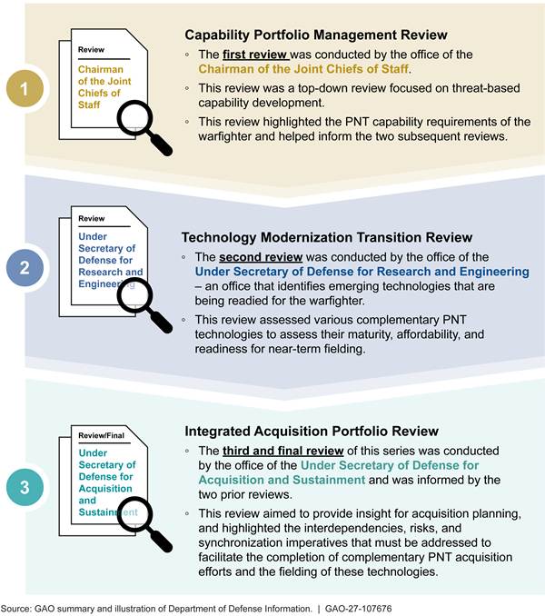
Outside of these reviews, the office of DOD’s CIO established the PNT Data Repository as a data collection and oversight tool to track DOD’s PNT modernization efforts. The CIO serves as the chair of the PNT Executive Management Board and provides secretariat services to the PNT Oversight Council. A CIO official specifically noted that the office tracks DOD’s prioritization of PNT modernization for each weapon system by consulting with the office of the Joint Chiefs of Staff, and monitors military service budgets to study whether they align with the PNT priorities of the Joint Staff and the combatant commands.[41] Using this overarching knowledge of the department’s PNT modernization efforts and priorities, DOD’s CIO office weighs in on the budgetary process by providing budget programming guidance to the military services through the budget certification process, according to the official.
DOD policy directs that the PNT Oversight Council coordinates its oversight activities with the various DOD components and organizations that provide or support the functions of the PNT enterprise.[42] While the efforts of the PNT Oversight Council and DOD CIO provide guidance to the military services on their range of PNT efforts, the military services maintain their independent authority over their budgetary resources that fund their respective PNT development and fielding efforts. Therefore, while the PNT Oversight Council can make recommendations to the military services on PNT priorities, the military services have budgetary autonomy and may decide not to follow the council’s recommendations. For example, notes from the PNT Executive Management Board and PNT working group meetings indicate that discussions were held regarding the Air Force’s inadequate funding of the aviation receiver programs. In addition, aviation receiver program officials noted in a briefing that due in part to “chronic underfunding,” the Air Force aviation receiver programs did not meet their development goals on their expected timelines.
The fragmentation of DOD’s PNT efforts across the military services limits the PNT Oversight Council’s ability to bring strategic alignment to DOD’s PNT enterprise. The PNT portfolio is vast and touches almost all vehicles, ships, aircraft, precision guided munitions, and dismounted personnel within the department. As result, numerous program offices across the Army, Navy, and Air Force manage PNT development and integration efforts. Based on portfolio management leading practices, we recommended in August 2022 that DOD ensure that the PNT Oversight Council creates strategic objectives and metrics to measure progress toward those objectives for DOD’s complementary PNT technology development efforts.[43] DOD agreed with this recommendation and has taken some steps to address it, such as including the complementary PNT systems in the PNT Oversight Council strategic planning deliberations.
Ineffective coordination of the fragmented interdependent PNT efforts among multiple military services—sometimes across more than one—hampers efficient alignment of those efforts. For example, the program managing the development of the M-code-capable GPS user equipment faced several challenges. The program had to manage not only the M-code receiver card development, but also needed to synchronize its efforts with those programs developing the modernized PNT receivers into which the cards would be integrated, along with the weapon systems into which those receivers would be installed and integrated. Responding to such challenges, in its May 2025 meeting, a PNT Oversight Council official expressed a “need to designate a single owner to the entire PNT value chain.”
Concerns about fragmentation have also led to recent efforts to make changes to how the PNT mission is structured. The House of Representatives version of the National Defense Authorization Bill for Fiscal Year 2027, if passed into law, would replace the current PNT Oversight Council with a single DOD official to manage DOD’s PNT enterprise.[44] This official would be required to inform Congress as to whether the military services’ budget requests would fully fund the GPS ground system and user equipment for each annual budget request. However, per the language of the bill, this official does not expressly have direct budget authority.
Pursuing modernized GPS and complementary PNT technologies to augment GPS requires foresight and planning. Integration timelines for weapon systems are often lengthy, and schedules must be properly aligned for the development of such modernized PNT technologies and their integration into weapon systems. Additionally, these timelines for integrating new PNT technologies can be further complicated by the interdependence of systems. For example, the military services will likely upgrade some munitions to use M-code before the capability is integrated into weapon systems that fire those munitions. These misalignments may cause synchronization issues for the munition prior to launch as the initial position is typically passed from the weapon system to the munition, and after launch if the munition needs to confirm its position mid-course and closer to its target.
In recent years, DOD has taken steps toward bringing greater coherence to PNT modernization and minimizing fragmentation by coalescing various PNT development efforts. The establishment of the Air Force’s M-code Aviation Receiver Joint Program Office started in 2024 by consolidating multiple aircraft PNT receiver efforts, as well as the MGUE card efforts, under a single joint program office managed by the Air Force. These program transitions were completed in May 2026. Prior to the consolidation, according to program officials, the M-code aviation receiver programs’ progress were hindered by chronic underfunding in budget planning and contractor underperformance, among other concerns. The PNT Executive Management Board and PNT working group specifically discussed the lack of planned funding for the M-code Aviation Receiver Enterprise (MARE) programs during meetings held in 2024 and 2025.
After consolidation, however, these programs, along with the MGUE card efforts, became subject to biannual progress reviews, an independent cost estimate, and an independent technology risk assessment as directed by the Office of the Under Secretary for Acquisition and Sustainment. These reviews were implemented to ensure that the overall MARE program’s cost, schedule, performance, and risk were closely managed under the new organization. The Fiscal Year 2027 President’s Budget Request also indicates that the previous underfunding in budget requests for the MARE programs will likely be corrected in fiscal year 2027, and possibly future years.
This consolidation also reduced the amount of fragmentation of effort across a broad range of Air Force and Navy aircraft. The merging of these PNT efforts under the M-code Aviation Receiver Joint Program Office, and the office’s progress in unifying efforts across multiple services, could potentially provide a model for an analogous consolidation of GPS modernization and complementary PNT efforts. These efforts could be consolidated within the Army, Navy, and Air Force, if such consolidations could yield a greater strategic alignment of the efforts underway by individual services toward DOD’s overall PNT objectives.
Complementary PNT efforts have not always been designated as a high priority for investments. A member of a PNT task force advising DOD indicated that with certain complementary PNT technologies, there needs to be a greater effort to prioritize the technologies to advance more rapidly. Better integration and leveraging of similar efforts across the Army, Navy, and Air Force, as was done for aircraft receivers, could produce efficiencies that might enable a faster delivery of PNT capabilities.
As the department’s PNT efforts are currently managed, DOD lacks reasonable assurance that its PNT investment decisions address pressing warfighting needs. Leading practices for Agile portfolio management state that leading companies identify technologies that will help deliver critical capabilities to products within their portfolios.[45] These leading companies also prioritize investments and allocate funds within them accordingly. If consolidation of GPS modernization and complementary PNT efforts into broader portfolios within the Army, Navy, and Air Force has strategic value, these efforts could potentially benefit from shared acquisition, integration, and fielding strategies. In addition, consolidating PNT modernization programs under a portfolio for each service could include synchronized schedules between complementary PNT capability development, PNT receivers, and the integration of both into weapon systems. Further, funding within a consolidated portfolio could be more easily shifted to the highest priorities to help ensure that warfighters receive the capabilities needed to address threats to GPS.
Conclusions
For more than 2 decades, DOD has worked and spent tens of billions of dollars to build the foundation for a fully modernized GPS and, more recently, to develop complementary PNT capabilities to use in the event that GPS is disrupted or is otherwise unavailable. Despite the long-standing efforts, considerable work remains to field modernized GPS and complementary PNT solutions. There are a number of complex remaining tasks and they require extensive coordination between DOD and the military services. Combining these fielding efforts with the tasks needed to integrate new M-code and multi-PNT receivers into each weapon system, along with handheld receivers for ground troops, could help address planning, funding, and oversight challenges. Consolidating these GPS modernization and complementary PNT efforts into larger portfolios within the Army, Navy, and Air Force, where it yields strategic value, as was done with aircraft receiver efforts across the Air Force and Navy, could help produce efficiencies. These efficiencies may improve schedule alignments between interdependent programs and ease the realignment of resources for higher priority programs within the portfolio to ensure that warfighters obtain these necessary capabilities to address current and future threats.
Recommendations for Executive Action
We are making the following three recommendations to DOD:
The Secretary of Defense should ensure that the Secretary of the Army assesses where consolidation of its GPS modernization and complementary PNT efforts would help ensure better strategic alignment with DOD and the other services, and develop a plan to consolidate them, similar to the manner in which the Air Force and Navy aviation M-code and multi-PNT receivers along with the MGUE Inc 1 and Inc 2 programs were consolidated into the Air Force’s M-code Aviation Receiver Joint Program Office. (Recommendation 1)
The Secretary of Defense should ensure that the Secretary of the Navy assesses where consolidation of its GPS modernization and complementary PNT efforts would help ensure better strategic alignment with DOD and the other services, and develop a plan to consolidate them, similar to the manner in which the Air Force and Navy aviation M-code and multi-PNT receivers along with the MGUE Inc 1 and Inc 2 programs were consolidated into the Air Force’s M-code Aviation Receiver Joint Program Office. (Recommendation 2)
The Secretary of Defense should ensure that the Secretary of the Air Force assesses where consolidation of the Air Force and Space Force’s PNT modernization efforts would help ensure better strategic alignment with DOD and the other services through its GPS modernization and complementary PNT efforts and develop a plan to consolidate them, similar to the manner in which the Air Force and Navy aviation M-code and multi-PNT receivers along with the MGUE Inc 1 and Inc 2 programs were consolidated into the Air Force’s M-code Aviation Receiver Joint Program Office. (Recommendation 3)
Agency Comments
We provided a draft of this report to DOD for review and comment. DOD provided written comments, which are reproduced in appendix II and summarized below. DOD also provided technical comments, which we incorporated as appropriate. In its comments, DOD concurred with all three recommendations.
In its comments on our first recommendation, DOD stated that the Department of the Army is currently well coordinated in its PNT modernization efforts and has found no duplication. However, the Army plans to participate in the Office of the Secretary of Defense’s PNT Deep Dive discussions to assess if consolidation could improve strategic alignment between DOD, the Army, and the other military services. Following the assessment, the Army intends to develop a plan for any appropriate consolidation actions.
In its comments on our second and third recommendations, DOD stated that both the Department of the Navy and Department of the Air Force plan to assess where consolidation of their GPS modernization and complementary PNT efforts would improve strategic alignment with DOD and the other military services. For the Department of the Air Force, DOD commented that the Air Force, in its assessment, intends to consider the relationship between Air Force and Space Force GPS modernization and complementary PNT efforts including opportunities to align them within existing joint PNT acquisition and governance structures.
We are sending copies of this report to the appropriate congressional committees, the Secretary of Defense, and the Secretaries of the Army, Navy, and Air Force. The report will be available at no charge on GAO’s website at https://www.gao.gov.
If you or your staff have any questions about this report, please contact me at LudwigsonJ@gao.gov. Contact points for our Offices of Congressional Relations and Media Relations may be found on the last page of this report. GAO staff who made key contributions to this report are listed in appendix III.

Jon Ludwigson, Director
Contracting and National Security Acquisitions
List of Committees
The Honorable Roger Wicker
Chairman
The Honorable Jack Reed
Ranking Member
Committee on Armed Services
United States Senate
The Honorable Mitch McConnell
Chair
The Honorable Christopher Coons
Ranking Member
Subcommittee on Defense
Committee on Appropriations
United States Senate
The Honorable Mike Rogers
Chairman
The Honorable Adam Smith
Ranking Member
Committee on Armed Services
House of Representatives
The Honorable Ken Calvert
Chairman
The Honorable Betty McCollum
Ranking Member
Subcommittee on Defense
Committee on Appropriations
House of Representatives
Section 1621 of the National Defense Authorization Act for Fiscal Year 2016 includes a provision that the Secretary of the Air Force provide quarterly reports and supporting documentation to us on, among other things, next-generation GPS acquisition programs.[46] The act also includes a provision that we brief congressional defense committees on the Air Force’s first report and, at our discretion, on subsequent reports. The National Defense Authorization Act for Fiscal Year 2025 expands the provision for us to also report on DOD development and fielding of complementary PNT efforts.[47] We issued reports on the overall GPS enterprise, on schedule risks to the ground control segment of the GPS mission, and on progress and challenges delivering modernized GPS user equipment in December 2017, May 2019, January 2021, May 2022, June 2023, and September 2024.[48]
Our current report examines:
1. the progress DOD has made in modernizing GPS and providing complementary PNT data to the warfighter;
2. the status of DOD efforts to develop and field modernized PNT receivers; and
3. the extent to which DOD has taken steps to oversee the PNT portfolio, and what challenges it is facing.
To assess the progress of DOD’s efforts to modernize its GPS and advance complementary sources of PNT, we reviewed pertinent documentation, such as program status briefings, budgets, and schedules. We also conducted interviews with relevant officials from DOD, the Army, Navy, Air Force, and Space Force. For information about the Space Force’s programmatic efforts in modernizing the GPS ground control and space segments, we interviewed program officials from the following programs:
· Global Positioning System III Follow-on (GPS IIIF) satellite;
· Next Generation Operational Control System (OCX); and
· OCX Block 3F.
To obtain further information about contract performance and testing for programs related to GPS ground and space segment modernization, we also interviewed officials and reviewed contract performance reports from the Defense Contract Management Agency and interviewed officials at the DOD Office of Developmental Test, Evaluation, and Assessments and the DOD Office of the Director, Operational Test and Evaluation.
To obtain information on DOD’s efforts to modernize or develop complementary PNT sources, we interviewed officials from the following offices:
· The Office of the Under Secretary of Defense for Research and Engineering, OUSD (R&E);
· Space Development Agency;
· Army Research Laboratory;
· Office of Naval Research;
· Naval Research Laboratory; and
· Air Force Research Laboratory.
To determine the status of DOD efforts to develop and field modernized PNT receivers and military code (M-code) capable receiver cards, we reviewed documents and interviewed officials. We interviewed DOD and military service officials and a contractor responsible for the planning and implementation of M-code and complementary PNT capabilities about the status of PNT receiver and M-code-capable receiver card programs that the services were responsible for developing, testing, and fielding. These included:
· Air Force Military GPS User Equipment (MGUE Increment 1 and MGUE Increment 2) Program Office;
· Air Force M-code Aviation Receiver Joint Program Office;
· Air Force Armament Directorate;
· Army All-Domain Sensing Cross-Functional Team;
· Army Portfolio Acquisition Executive Agile Sustainment & Ammunition;
· Army Office of the Project Manager for PNT;
· The Office of the Assistant Secretary of the Navy for Research, Development, and Acquisition;
· The Naval Air Systems Command’s Air Combat Electronics Program Office;
· Naval Sea Systems Command’s Automated Celestial Navigation Systems Program Office;
· The Headquarters Marine Corps Information Command, Control, Communications, and Computers;
· Office of the DOD Chief Information Officer;
· OUSD (R&E);
· OUSD (A&S);
· Joint Chiefs of Staff/J6 Command, Control, Communications, & Computers/Cyber; and
· BAE Systems, contractor.
For identified PNT receiver development efforts being pursued by the services, we sent a questionnaire to program officials. The questionnaire requested information and documents about a program’s planned capabilities, schedule, key milestones, budgets, and challenges. Based on the information collected, we identified the remaining risks and challenges that DOD needed to address to develop, procure, and field these M-code and complementary PNT capabilities along with the likely time frames when they will begin to be available.
To determine how DOD is overseeing PNT efforts and identify the challenges it is facing, we reviewed DOD documents and conducted interviews. This allowed us to understand the oversight structure and the scope of the GPS modernization and complementary PNT efforts. We assessed this information against DOD’s portfolio management practices and leading practices that we identified in prior work on Agile portfolio management.[49] We also analyzed the meeting minutes from the body charged with oversight of DOD’s PNT efforts, known as the PNT Oversight Council, to determine the main focus of those meetings. We interviewed officials from the following DOD offices:
· Office of the DOD Chief Information Officer;
· OUSD (R&E);
· OUSD (A&S); and
· Joint Chiefs of Staff/J6 Command, Control, Communications, & Computers/Cyber.
We also sent questionnaires to the identified PNT receiver development programs within the services. The questionnaires requested information on DOD’s oversight of the PNT enterprise and the programs’ interactions with the PNT Oversight Council and its working groups.
We conducted this performance audit from July 2024 to October 2026 in accordance with generally accepted government auditing standards. Those standards require that we plan and perform the audit to obtain sufficient, appropriate evidence to provide a reasonable basis for our findings and conclusions based on our audit objectives. We believe that the evidence obtained provides a reasonable basis for our findings and conclusions based on our audit objectives.
GAO Contact
Jon Ludwigson, LudwigsonJ@gao.gov
Staff Acknowledgments
In addition to the individual named above, J. Andrew Walker (Assistant Director), Brian Fersch (Assistant Director), Jonathan Mulcare (Analyst-in-Charge), Ruth Devan (Analyst-in-Charge), Pete Anderson, Lori Fields, Albirio Madrid, Bonita Oden, Christine Pecora, and Alyssa Weir made key contributions to the report. Nicolaas Cornelisse, Lorraine Ettaro, Chi L. Mai, Susan Murphy, Kate Sharkey, and Pamela Snedden also contributed to the report.
The Government Accountability Office, the audit, evaluation, and investigative arm of Congress, exists to support Congress in meeting its constitutional responsibilities and to help improve the performance and accountability of the federal government for the American people. GAO examines the use of public funds; evaluates federal programs and policies; and provides analyses, recommendations, and other assistance to help Congress make informed oversight, policy, and funding decisions. GAO’s commitment to good government is reflected in its core values of accountability, integrity, and reliability.
Obtaining Copies of GAO Reports and Testimony
The fastest and easiest way to obtain copies of GAO documents at no cost is through our website. Each weekday afternoon, GAO posts on its website newly released reports, testimony, and correspondence. You can also subscribe to GAO’s email updates to receive notification of newly posted products.
Order by Phone
The price of each GAO publication reflects GAO’s actual cost of production and distribution and depends on the number of pages in the publication and whether the publication is printed in color or black and white. Pricing and ordering information is posted on GAO’s website, https://www.gao.gov/ordering.htm.
Place orders by calling (202) 512-6000, toll free (866) 801-7077,
or
TDD (202) 512-2537.
Orders may be paid for using American Express, Discover Card, MasterCard, Visa, check, or money order. Call for additional information.
Connect with GAO
Connect with GAO on X,
LinkedIn, Instagram, and YouTube.
Subscribe to our Email Updates. Listen to our Podcasts.
Visit GAO on the web at https://www.gao.gov.
To Report Fraud, Waste, and Abuse in Federal Programs
Contact FraudNet:
Website: https://www.gao.gov/about/what-gao-does/fraudnet
Automated answering system: (800) 424-5454
Media Relations
Sarah Kaczmarek, Managing Director, Media@gao.gov
Congressional Relations
David A. Powner, Acting Managing Director, CongRel@gao.gov
General Inquiries
[1]GAO, GPS Modernization: Delays Continue in Delivering More Secure Capability for the Warfighter, GAO‑24‑106841 (Washington, D.C.: Sept. 9, 2024); GPS Modernization: Space Force Should Reassess Requirements for Satellites and Handheld Devices, GAO‑23‑106018 (Washington, D.C.: June 5, 2023); GPS Alternatives: DOD Is Developing Navigation Systems but Is Not Measuring Overall Progress, GAO‑22‑106010 (Washington, D.C.: Aug. 5, 2022); GPS Modernization: Better Information and Detailed Test Plans Needed for Timely Fielding of Military User Equipment, GAO‑22‑105086 (Washington, D.C.: May 9, 2022); Defense Navigation Capabilities: DOD Is Developing Positioning, Navigation, and Timing Technologies to Complement GPS, GAO‑21‑320SP (Washington, D.C.: May 10, 2021); GPS Modernization: DOD Continuing to Develop New Jam-Resistant Capability, but Widespread Use Remains Years Away, GAO‑21‑145 (Washington, D.C.: Jan. 19, 2021).
[2]National Defense Authorization Act for Fiscal Year 2025, Pub. L. No. 118-159, § 1606 (2024), amending subsection (c) of section 1621 of the National Defense Authorization Act for Fiscal Year 2016, Pub. L. No. 114-92 (2015) (10 U.S.C. § 2281 note). The National Defense Authorization Act for Fiscal Year 2016 included a provision for us to report on the performance of the GPS acquisition programs until they reach initial operational capability.
[3]Department of Defense, Capability Portfolio Management, DOD Directive 7045.20 (Sept. 25, 2023). This directive establishes policy for DOD components to define and manage different portfolios for various purposes across the defense enterprise. The instruction provides guidance for DOD components on using capability portfolio management across DOD to advise senior leadership on capability investment, divestment, and management. It both assigns responsibilities for capability portfolio management and provides the procedures for such management. GAO, Leading Practices: Agile Portfolio Management and Iterative Business Cases Drive Innovative Product Development, GAO‑25‑107130 (Washington, D.C.: Sept. 17, 2025). These Agile portfolio management practices were identified via our body of work assessing the leading practices used by commercial companies.
[4]GAO, Global Positioning System: Better Planning and Coordination Needed to Improve Prospects for Fielding Modernized Capability, GAO‑18‑74 (Washington, D.C.: Dec. 12, 2017); and Global Positioning System: Significant Challenges in Sustaining and Upgrading Widely Used Capabilities, GAO-9-325 (Washington, D.C.: Apr. 30, 2009).
[5]See National Defense Authorization Act for Fiscal Year 2024, Pub. L. No. 118-31, §1685(b) (2023). This mandate was implemented via a November 2024 acquisition decision memorandum. In the memorandum, the Under Secretary of Defense for Acquisition and Sustainment directed the Secretary of the Air Force to transfer the Military GPS User Equipment (MGUE) Inc 1 program from the Space Force to the Air Force. An April 2025 Assistant Secretary of the Air Force memorandum noted that the Space Force and Air Force agreed to transfer the GPS M-code receiver card development work on the MGUE Inc 2 program from the Space Force to the Air Force.
[6]Earth orbits include low, medium, and high and determine how quickly satellites move around Earth. Low Earth orbit is 180-2,000 km above Earth. Medium Earth orbit is 2,000-35,780 km above Earth. High Earth orbit is greater than 35,780 km above Earth.
[7]The Center for Strategic and International Studies (CSIS) is a nonprofit policy research organization. Center for Strategic and International Studies, Space Threat Assessment 2025, Report of the CSIS Aerospace Security Project (Washington, D.C.: April 2025).
[8]The Secure World Foundation is a private research foundation focusing on space sustainability and the peaceful uses of outer space. Secure World Foundation, Global Counterspace Capabilities 2025, Report of the Secure World Foundation (Washington, D.C.: April 2025).
[9]Department of Defense, Office of the Under Secretary of Defense for Research and Engineering, 2020 Positioning, Navigation, and Timing Science and Technology Roadmap (Alexandria, Va.: July 2020). See GAO‑21‑320SP and GAO‑22‑106010 for additional information on some of these efforts.
[10]The Space Development Agency’s PWSA is a partially deployed low Earth orbit satellite constellation that is planned to provide PNT signals in later planned versions of the satellites. The Army’s ALTNAV system relies on signals from a low Earth orbit constellation of commercial communications satellites controlled by an Army-developed control segment deployed worldwide. These satellites broadcast signals that are collected by Army-developed receiver equipment for PNT purposes.
[11]In this report, geophysical sources refer to Earth’s natural topography and features as well as human-made buildings and other structures. Celestial sources refer to natural celestial bodies like stars and planets as well as artificial human-made satellites on predictable orbits.
[12]UTC is the 24-hour time standard common to every place in the world and is determined by time laboratories in multiple locations using highly precise atomic clocks.
[13]National Defense Authorization Act for Fiscal Year 2016, Pub. L. No. 114-92, § 1603(a) (2015) codified as amended at 10 U.S.C. § 2279b.
[14]This acceptance is the government assumption of ownership of the system following the contractor’s submission of Material Inspection and Receiving Report (Form DD 250) and the Space Force’s evaluation of the system for acceptance.
[15]Time steering, according to DTE&A officials, refers to the ability of the ground control system to use timing sourced from the U.S. Naval Observatory to correct drift that occurs in the clocks on board the GPS satellites.
[18]The Space Force had planned for the OCX 3F program, a follow-on to the OCX Blocks 1 and 2 program, to deliver the capabilities necessary to carry out GPS IIIF satellite control functions.
[19]We previously reported on SDA’s efforts to build the PWSA satellite constellation and noted concerns with SDA’s approach. See GAO, Missile Warning Satellites: Space Development Agency Should Be More Realistic and Transparent About Risks to Capability Delivery, GAO‑26‑107085 (Washington, D.C.: Jan. 28, 2026); and Laser Communications: Space Development Agency Should Create Links Between Development Phases, GAO‑25‑106838 (Washington, D.C.: Feb. 26, 2025).
[20]The DOD concept of lightweight satellite navigation entails a satellite navigation system transmitting PNT signals that are encrypted through commercial certifications, and that are optimized for low-cost PNT receivers with low size, weight, and power requirements.
[21]In contrast to ALTNAV and PWSA, which operate in LEO, NTS-3 operates in a geosynchronous orbit. Satellites in geosynchronous orbit are 22,236 miles above Earth’s equator and move in sync with Earth’s daily rotation, completing one revolution every 24 hours.
[22]Multi-Global Navigation Satellite Systems entails the use of PNT signals from foreign global navigation satellite signals, such as Europe’s Galileo and Japan’s Quazi-Zenith Satellite System.
[24]A CDD details system level performance attributes to support development of one or more increments of a capability solution.
[25]We previously reported that in 2024, the Space Force intended to use the Air Force’s B-2 Spirit for platform testing of the aviation variant of the MGUE Inc 1 card. However, in October 2024, the Space Force requested a change to the aviation lead platform testing from the Air Force’s B-2 to the Army’s Gray Eagle uncrewed aircraft system. The Air Force milestone decision authority authorized the switch to prevent further cost and schedule delays to the aviation lead platform testing of the MGUE Inc 1 receiver card.
[26]The SAASM is designed to provide over-the-air rekeying of GPS receivers for the encryption and decryption of the GPS military signal, the precursor to M-code, as part of an enhanced GPS security architecture that provides more precise position information. The military GPS signal generally provides more precise location information than the civilian GPS signal but is not as precise as the joint aviation accuracy requirements in the MGUE 1 CDD.
[27]An ASIC is a type of integrated circuit chip designed and developed to perform a specific function for a defined application.
[28]The MTA pathway includes paths for rapid prototyping and rapid fielding efforts. The objective of a program using the rapid prototyping path is to field a prototype meeting defined requirements that can be demonstrated in an operational environment and provide for residual operational capability within 5 years of the MTA program start date. The objective of a program using the rapid fielding path is to begin production within 6 months and complete fielding within 5 years of the MTA program start date. Department of Defense, Operation of the Middle Tier of Acquisition, DOD Instruction 5000.80 (Dec. 30, 2019). See also GAO‑24‑106841.
[29]RMP is a steerable, high-power M-code signal, designed to provide warfighters with greater jamming resistance in contested environments.
[30]For the military services to achieve IOC, the system must have met minimum operational capabilities that address a user’s needs and be deployable to designated units or organizations that can operate and maintain the system.
[31]An engineering change proposal is a management tool used to propose a change to an existing system and its performance requirements and configuration. This proposal is prepared by a contractor to propose engineering changes within the scope of activity under that contract. See Defense Federal Acquisition Regulation Supplement 243.205-70.
[33]For the military services to achieve FOC, the system must fully complete development and be deployed to all designated units, or organizations must have received the system, and users are able to operate and maintain it to meet mission requirements.
[34]MOSA is a strategy for acquisition and design that includes technical architectures, which utilize open standards and promote a modular, loosely coupled, and highly cohesive system structure. It is used by complementary PNT sources from a variety of suppliers without redesigning the entire system. For the statutory definition of a MOSA, see 10 U.S.C. § 4401(c)(1).
[35]A CRPA includes an adaptive array of GPS antennae able to identify in real-time, the direction(s) of jamming signals, and adjust the amplitude and phase for each array element to minimize power reception in the direction(s) of the jamming signals while still maintaining directional reception of visible satellites.
[36]MTA rapid fielding path allows a military service to rapidly field a proven and mature technology to military units within 5 years of program initiation. See Department of Defense, Operation of the Middle Tier of Acquisition, DOD Instruction 5000.80 (Dec. 30, 2019).
[37]Size, weight, and power requirements for military systems involve balancing technologies designed to optimize size, weight, power, and cost. Various types of aircraft may have airframes with space, weight, and power constraints that limit the type of receiver that can be installed into the aircraft.
[38]A reference architecture is an authoritative source of information about a specific subject area (in this case a multi-PNT receiver) that guides and constrains multiple architectures and solutions.
[39]National Defense Authorization Act for Fiscal Year 2016, Pub. L. No. 114-92, § 1603(a), (2015) codified as amended at 10 U.S.C. § 2279b.
[40]Department of Defense, Capability Portfolio Management, DOD Directive 7045.20 (Sept. 25, 2023).
[41]Combatant commands are unified military commands responsible for planning and executing operations across a geographic region or function.
[42]See Department of Defense, Positioning, Navigation, and Timing, DOD Directive 4650.05 (June 9, 2016) (Chg. 3, Apr. 25, 2023).
[44]A bill for the National Defense Authorization Act for Fiscal Year 2027, H. R. 8800, 119th Cong., § 1602 (2026).
[46]National Defense Authorization Act for Fiscal Year 2016, Pub. L. No. 114-92, § 1621 (10 U.S.C. § 2281 note).
[47]National Defense Authorization Act for Fiscal Year 2025, Pub. L. No. 118-159, § 1606 (2024), amending subsection (c) of section 1621 of the National Defense Authorization Act for Fiscal Year 2016.
[48]GAO, GPS Modernization: Delays Continue in Delivering More Secure Capability for the Warfighter, GAO‑24‑106841 (Washington, D.C.: Sept. 9, 2024); GPS Modernization: Space Force Should Reassess Requirements for Satellites and Handheld Devices, GAO‑23‑106018 (Washington, D.C.: June 5, 2023); GPS Modernization: Better Information and Detailed Test Plans Needed for Timely Fielding of Military User Equipment, GAO‑22‑105086 (Washington, D.C.: May 9, 2022); GPS Modernization: DOD Continuing to Develop New Jam-Resistant Capability, but Widespread Use Remains Years Away, GAO‑21‑145 (Washington, D.C.: Jan. 19, 2021); Global Positioning System: Updated Schedule Assessment Could Help Decision Makers Address Likely Delays Related to New Ground Control System, GAO‑19‑250 (Washington, D.C.: May 21, 2019); and Global Positioning System: Better Planning and Coordination Needed to Improve Prospects for Fielding Modernized Capability, GAO‑18‑74 (Washington, D.C. Dec. 12, 2017).
[49]Department of Defense, Capability Portfolio Management, DOD Directive 7045.20 (Sept. 25, 2023). GAO, Leading Practices: Agile Portfolio Management and Iterative Business Cases Drive Innovative Product Development, GAO‑25‑107130 (Washington, D.C.: Sept. 17, 2025).